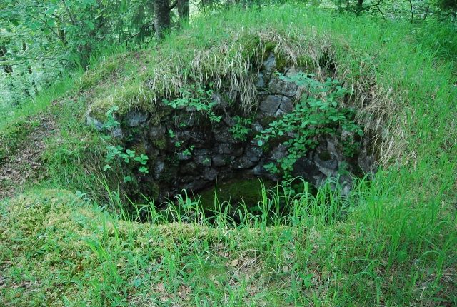
The remains of the Castle can be visited
Iburg Castle (Ruin)
The Iburg, also known as Rihburg or Riburg, is the ruin of a spur castle in the Albtal valley, 300 meters from Tiefenstein farm above the Tiefenstein district of the municipality of Görwihl in the Waldshut district in Baden-Württemberg. The castle is located on the territory of the former municipality of Buch.
Layout+
The spur castle is located on a high rock spur about 500 meters west of Steinbach on the left bank of the Alb, about one kilometer upstream from Tiefenstein Castle. The castle had a keep with a pre-built round tower on a base area of 7 by 12 meters and a wall thickness of 1.3 meters. Remains of the round tower's walls are still preserved from the former castle complex. Metz suspects that it is not a round tower but a cistern for a roof well that was attached to a residential tower. According to him, the complex had an outer and a main bailey.
The hilltop castle was probably built between the 10th or 11th century. The name "Iburg" is possibly derived from "Fliehburg" (refuge castle), but more likely from "Eibe" (yew). Such places were already used by the first Alamanni, who advanced as far as the Rhine, to bring their families and their belongings to safety in case of danger. Mostly, elevated positions that sloped steeply on several sides were preferred to limit the enemy attack to one direction, as is also the case with the Iburg. An old path led from the castle to the nearby settlement of Steinbach. Ebner (1950) therefore concludes that the castle was probably the seat of the noble family of Steinbach. The nobles mentioned in documents are: Johann von Steinbach in 1341 and 1350, Turingus in 1380, and another Johann von Steinbach in 1492. The Lords of Urberg can also be considered as possible builders of the complex. After the destruction of Tiefenstein Castle in 1272 and the loss of power of this noble family of the same name, the Iburg was probably abandoned. Large parts of the castle were removed as building material during the construction of the Albtalstrasse between 1854 and 1863. The northern part of the castle hill was destroyed in the process.
The castle is located on a rock spur about 500 meters west of Steinbach on the left bank of the Alb, about one kilometer upstream from Tiefenstein Castle. The castle had a keep with a pre-built round tower on a base area of 7 by 12 meters and a wall thickness of 1.3 meters. Remains of the round tower's walls are still preserved from the former castle complex. Metz suspects that it is not a round tower but a cistern for a roof well that was attached to a residential tower. According to him, the complex had an outer and a main bailey.
Near the complex runs a defensive wall, the so-called Landhag. Mone describes this, whose construction he attributes to Valentinian I in the period between 368 and 374, as follows: "This Landhag near Säckingen begins on the left bank of the Wehra near Öflingen and extends from there over the stream Heidenwühre to the east to the village of Wieladingen as far as the Murg, where it ends. Then it begins again near Steinbach on the Alb, goes from there over the ridge over the Steig farm, where it is called Steinweg (Stiegstrasse?), to the northeast as far as Aisperg." It remains to be investigated whether this fortification, which ran largely parallel to the Alb, was actually built at that time and, if so, whether it can indeed be attributed to the Romans and not to the local Alamannic tribe of the Lentienser.
Take Mobile History with you
You are reading this text for free. Premium adds what matters on the road: descriptions read aloud, sites found through your camera, whole regions taken offline.
- Every description, including the ~17,700 Premium sites
- Audio guide: have descriptions read to you on location
- AR finder: see sites through your camera, with distance and bearing
- Unlimited saved sites
14 days free, then from €2.99 a month. Cancel anytime.
Source: Wikipedia · Licence: CC BY-SA 4.0
This description draws on the facts documented in the linked Wikipedia article; Wikipedia content is licensed under CC BY-SA 4.0. Wording and editing: Mobile History.
Location: 47.6333, 8.0968