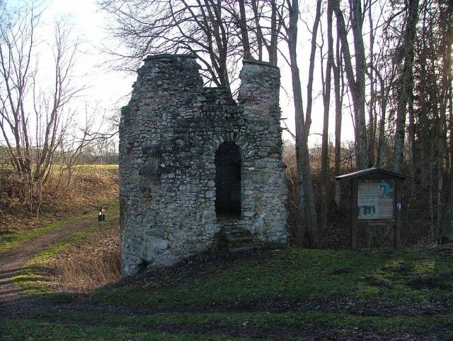
The remains of the Castle can be visited
Kalden Castle (Ruin)

Kalden Castle, also known as Neu-Kalden, is a castle ruin north of the market town of Altusried in the Swabian district of Oberallgäu in Bavaria. The hilltop castle stood on a large promontory 90 m above the Iller river and was secured to the west by a ravine, while the east side sloped steeply down to the Iller. Geological instability led to rockslides and loss of substance at the Alt-Kalden castle, mentioned in 1128 and destroyed before 1500, even in the Middle Ages. Today, only a narrow ridge remains.
Therefore, in 1515, a new building was constructed 300 meters south of the complex, which was then named Neu-Kalden. However, this new building was abandoned again as early as 1692 and finally demolished around 1840, except for a tower fragment. Today, a geologically impressive profile of the slipped castle site remains, showing gravel in the upper part and sands and marl in the lower part.
A family named Callindin, who served the Kempten Abbey, first appeared in 1128. In 1384, the castle and lordship passed to the Lords of Rothenstein, then in 1409 by purchase to the powerful Lords of Pappenheim, hereditary marshals of the Empire, who sold it back to the Rothensteiners three years later. In 1482, the Pappenheims again came into possession of the castle, this time through inheritance. Joachim von Pappenheim built Neu-Kalden Castle in 1515, which was sold to the Prince-Abbey of Kempten in 1692, but at the same time abandoned due to impending landslides. In 1985, the market town of Altusried acquired the ruin site.
Description+
A 25 to 30-meter wide neck ditch, which continues into the ravine at the southwest corner, separated the castle site from the adjacent plateau. The now ramp-like access to the castle plateau is flanked by a round tower with an outer diameter of about 6 meters, which was renovated in 1977, especially on the northern rear side and the top of the wall. It shows well-layered mixed masonry of river stones (flat rubble stones), Nagelfluh boulders, and sandstone quarry, with the infill masonry containing broken roof tiles. The inner wall on the first floor consists of river stones. The door to the east, located outside the ring wall, is a secondary installation and replaces an older loophole. The ground floor and first floor were flat-roofed and each had three slit loopholes. On the side, one can see the approximately 4 m high interlocking of a ring wall. Further wall remains are found west of the tower. Parallel wall lines indicate house-like structures.
Three hundred meters north of the plateau and difficult to access, the ridge-like edges of the former Alt-Kalden Castle with the very last remains of tuff masonry can still be found.
Take Mobile History with you
You are reading this text for free. Premium adds what matters on the road: descriptions read aloud, sites found through your camera, whole regions taken offline.
- Every description, including the ~17,700 Premium sites
- Audio guide: have descriptions read to you on location
- AR finder: see sites through your camera, with distance and bearing
- Unlimited saved sites
14 days free, then from €2.99 a month. Cancel anytime.
Source: Wikipedia · Licence: CC BY-SA 4.0
This description draws on the facts documented in the linked Wikipedia article; Wikipedia content is licensed under CC BY-SA 4.0. Wording and editing: Mobile History.
Location: 47.8241, 10.1997