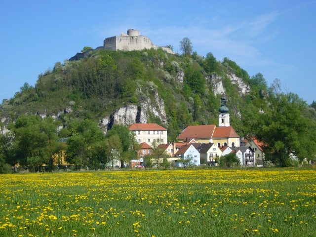
RuinKallmünz

Kallmünz Castle (Ruin)

Kallmünz Castle (Ruin)

The remains of the Castle can be visited

The Kallmünz castle ruin is a castle ruin on a mountain spur, the "Schlossberg" (Castle Hill), above the confluence of the Vils and Naab rivers, above the market town of Kallmünz in the Upper Palatinate district of Regensburg in Bavaria.

The castle is one of over 40 castles in the Regensburg region that are connected by the "Burgensteige" (Castle Trails).

The ruin of the spur castle, on the "Schlossberg" with the remains of an extensive prehistoric settlement dating back to Celtic times, shows a section rampart from the early Middle Ages (around 900), the so-called "Hungarian Wall", which protected a large refuge castle that served as a retreat for the surrounding population during the Hungarian invasions. It was first mentioned in a document by Bishop Wolfgang in 983.

The castle, strategically located between the Naab valley and the Vils valley at the intersection of several ancient roads, whose builders are not definitively clear, secured an imperial customs post described as "old" in 1230. In 1271, a Bavarian ministerialis named Hugo von Kallmünz is documented, and in the Treaty of Pavia in 1329, the castle is first mentioned as property of the Wittelsbach family.

The castle was pledged by Louis IV, Holy Roman Emperor, in 1344, first to Regensburg, later to Thuringia, then to Hesse. A few years later, various branches of the Wittelsbach family (Palatinate, Upper Bavaria, Palatinate-Neuburg) regained possession of the castle. In 1358, Count Palatine Ruprecht I was allowed to redeem the castle, in 1361 he had construction work carried out on it, and it was not until 1459 that Duke Albrecht III succeeded in regaining the castle and market of Kallmünz for Upper Bavaria.

During the Landshut War of Succession, Palatine troops set the castle on fire in 1504. After its reconstruction, it was plundered by imperial troops in 1633 during the Thirty Years' War, finally destroyed by fire by Swedish troops in 1641, and subsequently served as a quarry. In 1793, the castle became municipal property and has been repeatedly renovated since the end of the 19th century.

Construction History and Layout+

The crescent-shaped section rampart ("Hungarian Wall") dating from around 900 cut off the approximately 3-hectare rock spur to the north.

Approximately 1000 meters in front of the spur tip runs a two-phase outer section rampart over the Hirmesberg, dating from the Middle Bronze Age around 1600 BC, and approximately 100 meters in front of the medieval castle complex ran a likewise multi-phase inner section rampart from the La Tène period around 500 BC, which was later built over by the Hungarian Wall.

The datings of the older high medieval castle buildings vary from 1150 to 1280. The core castle was located at the very end of the promontory, directly above the steep drop to the Naab and Vils.

The Romanesque architectural ornamentation of the polygonal two-story palas with coupled round-arched windows, three-part pointed-arched windows, two knight's halls, and a castle chapel attached to the north, as well as the round 20-meter-high keep with a high entrance at 8 meters height, a diameter of 9.5 meters, and a wall thickness of approximately 2.3 meters made of limestone ashlar masonry, indicate a construction period around 1170 to 1780. Later additions and alterations point to a Gothic construction period.

Construction measures carried out by Count Palatine Ruprecht I in 1351 presumably referred to the 1.2-meter-thick curtain wall with its semicircular towers. The late Gothic zwinger with gatehouse is dated to the 15th century. The ascent to the high entrance of the keep was renewed in 1671, and in 1900 the keep received a new outer shell, whereby the castle gate was also provided with a pointed arch.

The castle complex today shows the well-preserved keep, which can be climbed during the summer months on Sundays and public holidays in conjunction with the opening hours of a castle café below the castle. Furthermore, the castle complex shows the mighty walls of the palas and other extensive wall remains, as well as a remnant of the castle chapel.

Current Events+

In autumn 2010, there were plans for increased tourist use: In addition to paving the access road for shuttle buses, taxis, and emergency vehicles, the construction of a stage with a gabion-style grandstand within the castle grounds and a stage with a grid or perforated sheet metal grandstand in the eastern palas area was considered. Furthermore, a 10 by 10 meter wooden functional building, a children's playground, and paved barbecue and fire pits were to be built. However, the plans were not uncontroversial and would have significantly altered the character of the castle. The citizens' petition "Hands off the Castle!", already referred to as "Castle 21" in the press, collected 570 valid signatures (i.e., about 25% of those eligible to vote) within just 12 days, instead of the necessary 231 votes. Subsequently, the mayor and the municipal council unanimously agreed to the citizens' vote. This means the issue is now on hold for a year. However, it offers the chance to constructively use the interim period for alternative planning.

Take Mobile History with you

You are reading this text for free. Premium adds what matters on the road: descriptions read aloud, sites found through your camera, whole regions taken offline.

  • Every description, including the ~17,700 Premium sites
  • Audio guide: have descriptions read to you on location
  • AR finder: see sites through your camera, with distance and bearing
  • Unlimited saved sites

14 days free, then from €2.99 a month. Cancel anytime.

Source: Wikipedia · Licence: CC BY-SA 4.0

This description draws on the facts documented in the linked Wikipedia article; Wikipedia content is licensed under CC BY-SA 4.0. Wording and editing: Mobile History.

Location: 49.1627, 11.9521