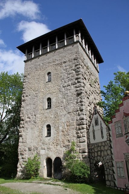
The remains of the Castle can be visited
Kemnat Castle (Ruin)

The former Kemnat Castle was the seat of the medieval lordship of Großkemnat. Of the once significant hilltop castle, essentially only the keep remains today, which is mistakenly referred to as "Römerturm" (Roman Tower) and is marked as a watchtower on maps. It stands in Großkemnat, a district of the East Allgäu town of Kaufbeuren, located about four kilometers outside the center. The name of the castle derives from the Latin caminata, which stands for a heated chamber or building. The history of the castle is closely linked to the history of the villages of Groß- and Kleinkemnat.
The castle was built around 1185 by Volkmar and Markward von Apfeltrang. They were vassals of the Counts of Ronsberg. Soon they named themselves after their new castle, the Lords of Kemnat. The most important lord of the castle and man of his lineage was Volkmar II von Kemnat, who received the epithet "the Wise". He was the city Vogt of Constance and founder of the Cistercian convent of Oberschönenfeld. In his time, Kemnat Castle was a scene of High Medieval art and culture, such as Minnesang. As a close confidant of King Konrad IV, Volkmar II von Kemnat rose to the rank of Imperial Ministerialis in 1246. From 1263, he also concerned himself with the education of Conradin, the last male heir of the Staufer imperial house.
In 1282, Volkmar II is mentioned for the last time. In 1284, his son Markward took over the castle. Around 1300, Kemnat Castle passed by inheritance to the Lords of Ramschwag, and almost 100 years later, it came into the possession of the Lords of Benzenau. During the Peasants' War in 1525, the castle was one of the few in Allgäu not to be captured. Simprecht von Benzenau sold the castle in 1551, along with communities and the right of Vogt, to Kempten Abbey, which established an administrative office there and built an official residence for it.
In the course of secularization in 1804, after the castle had been sold to a private individual, all buildings except the keep, the castle tavern, and the official residence were demolished, including a chapel that stood in the northeast of the castle courtyard.
In 1838, the Historical Society of Swabia acquired the tower and had it repaired in 1851. Further renovations took place in 1884, 1925, and 1957. The dilapidated castle tavern in the western corner of the courtyard was demolished in 1978. In 1984, the tower became the property of the city of Kaufbeuren, which had a viewing platform with a roof installed. Furthermore, the remaining keep, the official residence, and the rest of the castle grounds were renovated. In 1985, the 800th anniversary of the castle was ceremoniously celebrated. Today, a castle association, together with the city of Kaufbeuren, takes care of the complex.
Description+
The fortress is typologically classified as a spur castle. The approximately triangular plateau of the main castle lies on a hill spur projecting to the east, from whose steep slopes mighty conglomerate banks emerge. The main castle is cut off from the plateau by a neck ditch up to eight meters deep and 20 meters wide. The High Medieval parts of the castle consist largely of the conglomerate rock obtained from the ditch excavation, which was further processed into large ashlar blocks.
The castle complex is protected by steep slopes to the north and east. In the northwest and southwest, some fragments of the curtain wall are preserved. These wall remains form the outer walls of the preserved official residence and the former castle tavern, demolished in 1978. To the south and east, a shallow slope ditch with a rampart runs around the castle hill. To the southwest, a footpath leads up from the valley, opening into the plateau of the main castle between the keep and the well.
The well, which was originally in the middle of the castle courtyard, is located 20 meters east of the tower and is 26 meters deep. West of the official residence, which is now privately inhabited and serves as a castle tavern, lies the artificially created neck ditch.
Today's village of Großkemnat goes back to the economic or farmstead or a spacious outer bailey. Due to modern overbuilding, however, no clear terrain features can be recognized here, apart from minor wall remains. At house No. 24, a commemorative plaque installed around 1933/34 commemorates the former farmstead of the castle.
A larger stone tablet is embedded above the ground-level entrance of the keep. Such tablets are found at most castle ruins and castle stables in the region. They are predominantly due to the initiative of the former mayor of Kempten and passionate castle researcher Otto Merkt. The inscriptions on these memorial stones are not always historically accurate.
The grounds of Kemnat Castle are used for open-air theater performances, and there is also a "Theaterstadl" (theater barn) of an association there. A recreational area is located nearby.
The Kempten Administrative Castle
In the High Middle Ages, the keep stood freely in front of the curtain wall. Due to new construction from the mid-16th century onwards, the exact location of the medieval castle buildings can no longer be reconstructed.
The 16th-century administrative castle is well documented by three situation plans in the chronicle of the Blöcktach pastor Guggemos. The drawings were made shortly after the demolition.
The keep was incorporated into the five-story south wing during the new construction and was opened up on the northwest side for this purpose. To the northwest, a three-story building wing adjoined it. The northeast building is also said to have been three stories high. The St. Anna Chapel was located on its ground floor. Probably the castle's palas stood at this spot before. To the south, a wall section delimited the narrow castle courtyard, in the center of which was the well. The high south wall had no battlement and was covered with bricks.
The representative rooms were on the second floor of the south wing. A "dining room" and a "prince's room" are documented. The keep was raised during the renovation. The upper floor is said to have been built of tuff stone.
The state of construction shortly before the demolition in the early 19th century is shown in a reconstruction model by the carpenter Marzell Schwarz in the local museum of Kaufbeuren. Here, the terrain profile of the former outer bailey is also reproduced.
The defensive character of the complex was greatly reduced by the renovation. In the early modern period, the castle served more as an administrative center of the Kempten Abbey's lordship. Even the mighty keep no longer served for defense but merely rose as a symbol of law and power on the castle grounds.
In front of the actual administrative castle, two outbuildings flanked the access road to the west of the main castle. The preserved official residence was renovated in 1984. The dilapidated old castle tavern in the northwest was already demolished in 1978. Since then, the remains of the High Medieval curtain wall made of large conglomerate ashlar blocks stand freely on the edge of the slope (children's playground).
The Keep
The inaccurate designation "Römerturm" (Roman Tower) for the keep dates from the 19th century and is still common today. It is square with a side length of 9.3 meters and consists of large bossed conglomerate ashlar blocks. On the approximately three-meter-thick base sit four further floors, which are topped by a modern viewing platform with a tent roof. The keep is now used as a viewing tower and is freely accessible during the day. To the south, it offers a panorama from the Wetterstein Mountains over the Tannheim and Lechtal Mountains to the Allgäu High Alps.
The large main tower was opened up on the north side in the 16th century and incorporated into the new construction of an annex. At that time, large window niches were also cut into the walls, and the current ground-level access was created. The former high entrance originally opened in the middle of the northwest wall into an unvaulted shaft.
The keep was completely faced with large bossed ashlar blocks with a wide margin draft. The northwest front, opened up in the early modern period, was closed with brickwork in 1851 and served for some years as the dwelling of a poor widow. The municipality of Kleinkemnat actually wanted to sell the tower for demolition in the 19th century. Since the large bossed ashlar towers of the High Middle Ages were generally dated to Roman times at that time, the Historical Society of Swabia finally decided to purchase the historical monument.
The mighty main tower of Kemnat Castle strongly resembles the keep of the castle ruin Helmishofen, located to the east near Osterzell. This large conglomerate tower is also referred to as "Roman" or "watchtower" and is used as a viewing tower and is freely accessible.
Take Mobile History with you
You are reading this text for free. Premium adds what matters on the road: descriptions read aloud, sites found through your camera, whole regions taken offline.
- Every description, including the ~17,700 Premium sites
- Audio guide: have descriptions read to you on location
- AR finder: see sites through your camera, with distance and bearing
- Unlimited saved sites
14 days free, then from €2.99 a month. Cancel anytime.
Source: Wikipedia · Licence: CC BY-SA 4.0
This description draws on the facts documented in the linked Wikipedia article; Wikipedia content is licensed under CC BY-SA 4.0. Wording and editing: Mobile History.
Location: 47.8832, 10.5852