The remains of the Castle can be visited
CastleKüssaberg-Bechtersbohl
Küssaburg Castle (Ruin)
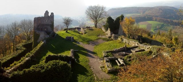
The Küssaburg, also known as Burg Küssaberg or "Küssenberg" (presumably derived from the Roman "Cossinius"), is the ruin of a hilltop castle in Bechtersbohl, a district of the municipality of Küssaberg, in the Waldshut district, Baden-Württemberg.
The hilltop castle is one of the most significant historical monuments on the High Rhine and a landmark of the Waldshut district. Its construction period is presumed to be between 1125 and 1141. The current ruin was, among others, owned by the Counts of Küssenberg, the Diocese of Constance, and the Counts of Sulz. The castle, later expanded into a fortress, was destroyed by a fire set by the garrison on March 8, 1634, upon the approach of the Swedish army in the Thirty Years' War, and by a landslide on December 25, 1664. In the 19th century, the excavation of the castle ruin began, and it has since been a popular excursion destination in the region.
The ruin is located above the village at an altitude of about 634 meters. It is a landmark of this region and overlooks the Klettgau, which extends east of the castle, and the Rhine Valley (High Rhine). It can also be seen from the Southern Black Forest and from Aargau in Switzerland.
The exact history of its origin is unknown, but it is speculated that the Küssenberg was already inhabited by Celts. Remains of a stone wall could indicate an oppidum, a Celtic refuge castle. It is also presumed that a watch and signal tower stood at the same location about 2000 years ago to secure the section of the Roman military road from Tenedo (Bad Zurzach/Switzerland) to Juliomagus (Schleitheim/Switzerland).
The first documentary evidence of the castle's existence, then also called "Hochschloß" (High Castle), dates from 1141. It reports on the noble family of Baron or Count Heinrich von Küssenberg. Heinrich III von Küssenberg, the last of his lineage, sold the castle around 1240 to the Bishop of Constance, Heinrich von Tanne.
Due to an inheritance claim by the Count of Lupfen, a dispute arose over the rightful ownership of the Küssaburg by the Prince-Bishopric of Constance. Later, a settlement was reached in which the Bishop was finally allowed to keep the complex in 1251, and the Count was granted Stühlingen, which also originated from the possession of Count Küssenberg. Thus, around 1120, the Landgraviate of Stühlingen emerged from the Landgraviate of Klettgau.
Under the rule of the Diocese of Constance, which appointed a vogt to administer the castle, the castle was expanded and fortified with a ring wall. The castle and the adjacent settlement to the east were granted town rights in 1346. Some communities, which are now also grouped under the name Küssaberg, had been incorporated at that time as "Küssenberger Schloß und Tal" (Küssenberg Castle and Valley). The castle and the property were then frequently pledged. In 1444 by the Bishop of Constance, Heinrich von Hewen, to the knight Bilgeri von Heudorf. In 1497, the Counts of Sulz, who already owned Tiengen and the Klettgau, bought the castle and the suburb. A price of 6,000 guilders was paid, and the castle was to be administered by this family until the male line of succession died out.
In the Swabian War of 1499, the Küssaburg and the city of Tiengen were completely destroyed by the Confederates. The garrison of the Küssaburg under the command of the legendary Remigius Mans, about 25 men strong, mostly consisting of local farmers, mutinied and set fire to the castle themselves so that it would not fall into enemy hands, and surrendered to a force of about 500 Confederates who had heavy artillery. 20 mutineers were executed after their retreat to Waldshut. After the Peace of Basel, the burnt-out castle was returned to the Counts of Sulz. The city of Tiengen remained occupied by Schaffhausen for several years.
The Klettgau farmers, some of whom were serfs, suffered under harsh tax obligations. Anyone who evaded serfdom could even be punished with the loss of all their possessions. The years 1524 and 1525 fell into a period marked by the Reformation and the growing self-awareness of the rural population. Much was propagated and people were incited; it culminated in the German Peasants' War in 1525. The Klettgau farmers, poorly equipped militarily, made four futile attempts that year to storm the Küssaburg, which was occupied by about 40 Austrian mercenary soldiers and other castle residents under Count Rudolf V of Sulz. The castle experienced its largest battle on November 4, 1525, a Saturday, at 3 p.m. Hours earlier, the peasant army, reinforced by 200 Swiss and a cannon from Waldshut, had confronted the 700 landsknechts of the nobility west of Grießen. Equipped with bladed weapons, they dared to storm the castle. However, the rebellious peasant army could not handle their weapons nearly as well as the soldiers, who also had arquebuses and crossbows. The chronicle of the Bernese Valerius Anshelm reports that around 200 peasants died and many houses were destroyed: "Women and children fled to Kaiserstuhl during the night with such pitiful cries and weeping that they had to be let in out of compassion." The unequal battle ended deep in the night at the Grießen cemetery; the peasants had to surrender. It was not only the finale of the Peasants' War but also the end of the attempt to introduce the Reformation in the Klettgau. A cruel punitive judgment followed. The soldiers from Zurich were let go, but the leader of the peasants, Claus Wagner from Grießen, as well as the Reformed pastor Hans Rebmann, had their eyes gouged out. Many peasants who escaped with their bare lives became victims of plundering soldiers, had to pay fines, or were mutilated by having their fingers chopped off.
Source: Wikipedia · Licence: CC BY-SA 4.0
This description draws on the facts documented in the linked Wikipedia article; Wikipedia content is licensed under CC BY-SA 4.0. Wording and editing: Mobile History.
Location: 47.6019, 8.3535