RuinHausen im Tal

Lägelen Castle (Ruin)

Lägelen Castle (Ruin)

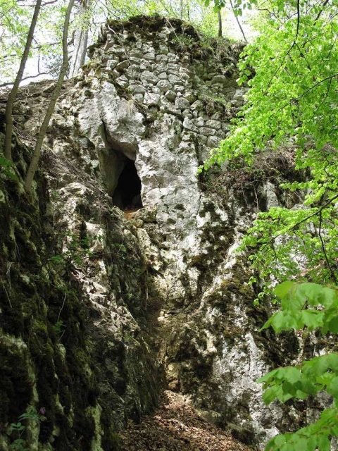
The remains of the Castle can be visited

The Lägelen ruin, also known as Wagenburg, are the remains of a hilltop castle above Hausen im Tal, a district of the municipality of Beuron in the Sigmaringen district of Baden-Württemberg.

It is reported of the castle, named after the Knights of Lägelen, that a cruel maiden haunts the caves beneath the castle rock. With her black poodle, she is said to guard a treasure to this very day.

The castle was located 350 meters southeast of the church of Hausen im Tal on a rock cliff directly protruding into the Danube valley. Today, only the few remaining wall fragments of the spur castle on the so-called "Schlossfelsen" (Castle Rock), above the current "Wagenburg" campsite in the district, bear witness to it.

The Wagenburg, as it is popularly known, was founded by the Knights of Lägelen. Its origin is assumed to be around 1100. The first written source is found in 1243 with the mention of a Nordewinus de Lagelun. Only a few decades later, the probable relocation to Pfullendorf followed. In 1277, one of the Knights of Lägelen, Cunradus, is last mentioned as a citizen in Pfullendorf. Around 1380, the complex was merely a castle site (Burgstall) and held as a fief by the Lords of Hausen. In 1424, it was again mentioned as a Burgstall. In 1516, the dilapidated Lägelen Castle was owned by Sixtus von Hausen. Around 1850, walls said to be chest-high were still standing.

Description+

The core castle, not very large with a footprint of about 26 x 20 meters, was secured by a neck ditch deeply cut into the rock, as well as two other shallow ditches in front of the spur's base, opposite the Alb plateau. Possibly, a small outer bailey on an area of 15 x 20 meters behind the second ditch completed the protection of the access to the core castle. Only here are the few preserved wall remains found. Behind a rocky ridge, over which the ascent to the core castle takes place, stand the remains of a 3.30 meter thick and about 4 meter high shield wall above a small cave. On the valley side and in the northern corner, up to two meter high retaining wall remains are found. On the south side, a layer of large bossed ashlar has been preserved, indicating a massive structure (possibly a keep).

Take Mobile History with you

You are reading this text for free. Premium adds what matters on the road: descriptions read aloud, sites found through your camera, whole regions taken offline.

  • Every description, including the ~17,700 Premium sites
  • Audio guide: have descriptions read to you on location
  • AR finder: see sites through your camera, with distance and bearing
  • Unlimited saved sites

14 days free, then from €2.99 a month. Cancel anytime.

Source: Wikipedia · Licence: CC BY-SA 4.0

This description draws on the facts documented in the linked Wikipedia article; Wikipedia content is licensed under CC BY-SA 4.0. Wording and editing: Mobile History.

Location: 48.0816, 9.0415