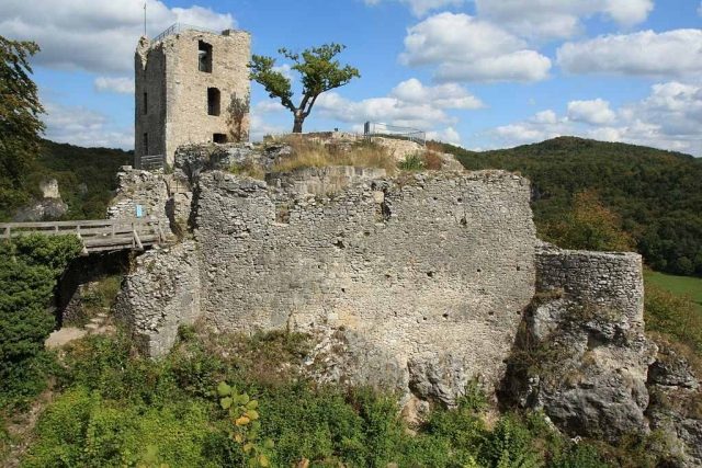
The remains of the Castle can be visited
Neideck Castle (Ruin)
The castle ruin Neideck is a former high medieval noble castle above the village of Streitberg, a district of Wiesenttal in the Upper Franconian district of Forchheim in Bavaria.
Due to its exposed location high above the Wiesent valley, it has become a landmark of Franconian Switzerland. The castle ruin is freely accessible at all times and serves as a viewpoint thanks to the accessible residential tower.
The castle ruin is located in the Franconian Switzerland-Veldenstein Forest Nature Park, about 800 meters east of the church of the village of Streitberg. It lies above the Wiesent valley on a spur north-northeast of the Wartleitenberg. The ruin can be reached via various hiking trails from the valley or from the villages on the plateau.
Around Neideck Castle, there were many other former castles: to the northwest, the Streitberg ruin; to the north, the Kulk castle site on the mountain called Guckhüll; to the east, the Wöhr tower castle, located on a former river island of the Wiesent near the hamlet of the same name. To the southeast, in the village of Trainmeusel, there was also a castle, of which a gable end is still visible. In the immediate vicinity of Neideck, about 250 meters southwest and above it, lay the Wartleiten castle site, and on the Hummerstein above Gasseldorf, an early medieval castle site.
Prehistory and Early History
The high plateau above the Wiesent valley served as a settlement site already in prehistoric times. Archaeological evidence of settlement traces from the Urnfield period, the late Hallstatt and early La Tène periods, the early Roman Imperial period, and the Migration Period has been documented. The unusual size of the medieval castle and the two extensive outer bailey with their deep moats could indicate an early medieval rampart.
Builders
The castle was first mentioned in a document in 1312 as property of the noble free lords of Schlüsselberg. However, a Heinrich von Neideck already appeared in a written source in 1219. The castle was therefore probably built in the 12th century, possibly as early as 1150/60. At that time, only a small wooden outer bailey would have stood in front of the core castle on the prominent rock formation above the Wiesent valley.
Schlüsselberg Possession
Since 1312, it was in the possession of Konrad II von Schlüsselberg, the most important and last representative of his lineage. He expanded Neideck into a fortress. With an area of 140 by 200 meters, it was one of the larger German castle complexes. The shield wall, outer and inner moat, two artillery towers, main moat with bridge, the residential tower, and adjacent parts of the main castle are still clearly visible. When Konrad von Schlüsselberg was in a feud with the bishops of Würzburg and Bamberg and the burgraves of Nuremberg in 1347 due to the establishment of a toll station, he was attacked and defeated by them. Konrad von Schlüsselberg died on September 14, 1347, from a stone projectile from a trebuchet, and the castle was destroyed. After the siege, Neideck became the official seat of the bishops of Bamberg.
Peasants' War and Destruction in the Second Margrave War
After the castle had survived the Peasants' War in 1525, it was captured and set on fire in the Second Margrave War in 1553 by the mercenaries of Margrave Albrecht Alcibiades of Brandenburg-Kulmbach. Since then, it has been a ruin.
Until the early 19th century, the complex served as a quarry for the inhabitants of the valley. The decay was further accelerated between 1737 and 1743 by the quarrying of the castle rock for marble extraction.
The increasing decay of the castle remains prompted the municipality of Streitberg to undertake initial preservation measures shortly after the Second World War. In 1996, the Forchheim district began a comprehensive renovation of the ruin, which was completed in 2008 with the opening of an Archaeological Park in the castle area. Although the work was accompanied by archaeological excavations, it was not always carried out according to the latest monument preservation methods.
Description+
The large castle complex consists of three sections separated by deep neck ditches. The outer bailey alone was secured by a moat approximately 100 meters long, 22 meters wide, and about 7 meters deep. The high shield wall rising behind it was built around 1300. Of the other buildings, only minor foundation traces remain.
The inner bailey was reinforced in the early 16th century by two partially preserved artillery rondels. The cross-key loopholes of the eastern tower were designed for arquebuses and crossbows. The rectangular loopholes of the western rondel were probably built around 1531/32. This bulwark flanked the access. The curtain wall between the rondels, along with the gate of the inner bailey, has almost completely disappeared.
The main castle is located on a rock spur projecting to the northeast. The mighty residential tower still rises three stories high. It was built after the destruction of the castle from 1347 onwards on still usable older foundations and wall sections. The former barrel vault of the ground floor probably dates back to the early 13th century. Above the preserved three stories, there was originally a fourth stone upper story, possibly also a half-timbered structure. The obligatory elevated entrance has been preserved on the first floor; the ground-level access was only created in modern times. Since 2008, a staircase allows ascent to the top of the wall.
The remaining parts of the core castle largely date from around 1480, when the fortress was expanded and reinforced after a siege. The barrel-vaulted cellar of a building and a well shaft are still recognizable. The historical access consisted of a late medieval gatehouse and a masonry bridge over the deep neck ditch. A short drawbridge lay in front of the gatehouse.
The castle site is listed by the Bavarian State Office for Monument Preservation (Archaeological Monument Preservation) as a hilltop settlement of the Urnfield period, the late Hallstatt and early La Tène periods, the early Roman Imperial period, and the Migration Period under monument number D-4-6133-0110. The subterranean parts of the castle ruin from the Middle Ages and early modern period are also considered archaeological monuments.
The name of the castle probably derives from its location on a "niederes Eck" (low corner). Due to this militarily very unfavorable location, a stone watchtower was erected on the ridge above the complex. This tower was surrounded by a ditch, which is still visible in the terrain. The almost completely disappeared tower is commemorated by the place name Wartleiten (monument number D-4-6133-0153).
Take Mobile History with you
You are reading this text for free. Premium adds what matters on the road: descriptions read aloud, sites found through your camera, whole regions taken offline.
- Every description, including the ~17,700 Premium sites
- Audio guide: have descriptions read to you on location
- AR finder: see sites through your camera, with distance and bearing
- Unlimited saved sites
14 days free, then from €2.99 a month. Cancel anytime.
Source: Wikipedia · Licence: CC BY-SA 4.0
This description draws on the facts documented in the linked Wikipedia article; Wikipedia content is licensed under CC BY-SA 4.0. Wording and editing: Mobile History.
Location: 49.8092, 11.2328