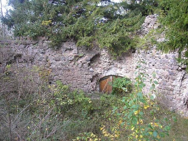
The remains of the Castle can be visited
Nesselburg Castle (Ruin)

Nesselburg Castle is a castle ruin south of the market town of Nesselwang in the Ostallgäu district of Bavaria. The ruin is located at an altitude of approximately 1038 meters on the cone of an outlier of the Alpspitze, known as "Kappelköpfel".
The fortress was built towards the end of the 13th century by the noble free lords of Rettenberg. The first documented mention of the castle dates back to 1302. Shortly thereafter, the Rettenbergers pledged the lordship to the Prince-Bishopric of Augsburg, but received it back as a fief. From 1350, the "Burch ze Nesselwanch" became the center of an administrative district (Pflegamt), as the last Rettenberger, Heinrich, had died childless. Heinrich's relative Peter von Hohenegg, who had claimed the inheritance, received 1300 pounds Heller from the Prince-Bishopric as compensation.
During the Peasants' War in 1525, the rebels plundered the administrative seat and set it on fire. Afterwards, the castle was made habitable again.
The Augsburg administrators and bailiffs inhabited Nesselburg Castle until 1595, when another fire made the rooms uninhabitable. In 1601, the Prince-Bishopric therefore acquired a house on Nesselwang's main street as the new administrative seat. This property also fell victim to the flames in 1635 during the Nesselwang town fire. Subsequently, a new official building, which still stands today, was built on the old site.
The castle was acquired in 1996 by a private buyer, who had renovation measures carried out on the endangered masonry in 1997. However, the renovation was stopped after one year.
Description+
In addition to ditches and terrain traces, larger remains of walls have been preserved, which have been gradually renovated since 1997.
A neck ditch protects the complex against the hillside, and to the east and west, the terrain drops steeply into the lateral stream ravines. On the rectangular castle plateau, approximately 30 x 23 meters in size, larger remains of the masonry still stand upright. In the north stood the palas, in the south are the remains of the approximately 2.6 meter thick and up to seven meter high shield wall. The eastern connecting wall to the palas has completely disappeared, while the western one with the gate next to the main building is still present. The north wall of the palas is also largely missing.
The irregular masonry consists of river gravel, Nagelfluh, sandstone, and tuff. At the southeast corner, remains of corner ashlar can still be found. The old castle path leads from the northwest to the gate opening. In front of it, another ditch cuts through the hillside to the north.
Take Mobile History with you
You are reading this text for free. Premium adds what matters on the road: descriptions read aloud, sites found through your camera, whole regions taken offline.
- Every description, including the ~17,700 Premium sites
- Audio guide: have descriptions read to you on location
- AR finder: see sites through your camera, with distance and bearing
- Unlimited saved sites
14 days free, then from €2.99 a month. Cancel anytime.
Source: Wikipedia · Licence: CC BY-SA 4.0
This description draws on the facts documented in the linked Wikipedia article; Wikipedia content is licensed under CC BY-SA 4.0. Wording and editing: Mobile History.
Location: 47.6119, 10.5026