CastleThusis

Obertagstein Castle (Ruin) (Thusis)
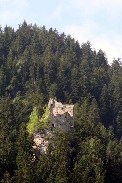
Obertagstein Castle (Ruin) (Thusis)

The remains of the Castle can be visited

The ruin of Obertagstein Castle is located in the municipality of Thusis in the Swiss canton of Graubünden. The ruin of Obertagstein Castle lies on the slopes of Piz Beverin on a rock headland that drops vertically on all sides, southwest of Thusis. At the foot of the rock, a mule track led to the Saissa Alp. The castle is easily accessible on foot from Thusis in about an hour, first via a forest road, then finally via a steep forest path.

Of the twelve recorded documents up to 1500, nine use the form Tagstein or similar. However, in the first mention in 1322, the form Taxstein appears (... ze Taxstein uf der Burch), in 1360 Taxstain, and in 1487 even Tachsstain; in 1538 the castle is still called Taxstein. Therefore, a derivation of the name from the badger (Latin: taxus) seems plausible: a place where badgers reside. Since the older records point to the badger, it can be assumed that, facilitated by the omission of a consonant, the change from Taxstein to Tagstein occurred.

Layout+

The complex is situated behind a mighty shield wall, which protected the actual castle on the mountain side. The walls are built of layered rubble stone, occasionally in opus spicatum.

The complex was built in at least two phases, which suggests a longer period of habitation. The architectural concept with a shield wall and palas, and the residential furnishings, indicate a rather late construction period at the end of the 13th century.

The oldest part occupied only the western corner of the rock headland and consisted of a palas with five stories leaning against the shield wall. Access was at ground level from the east. To the north was a latrine bay. In the southwest corner, a mighty round smoke vent is clearly visible. At the height of the fifth story, in the middle of the wall, there is a double round-arched window with tuff surrounds. The oldest building stock includes a cistern, which was embedded inside the shield wall in a natural rock crevice. Water was directed from the roof and via wooden channels through a small canal under the windowsill directly into the cistern, as is still clearly visible.

Access was through a gate, later walled up, at the southwest corner. Below the gate are the beam holes for the wooden ascent. From the gate, a narrow zwinger led over a narrow rock ledge to a gate on the southeast side. As can be seen on the inside of the shield wall, the palas on the northern inner side was no higher than two stories; although a further, wooden upper story cannot be entirely ruled out.

In a second expansion phase, the superstructure was extended over the entire rock, and the previously undeveloped eastern part was enclosed by a wall. The former latrine bay was converted into a bay window, and a new latrine bay was built to its east in the new wall, which, incidentally, is still used today, as a glance over the wall shows. The kitchen was in the southeast. In the fire debris, remains of grain and nutshells were found, as well as parts of kitchen utensils such as mincing knives and copper kettles.

The new access led from the southern outer zwinger over a wooden bridge to the lower new gate in the east above the vertically dropping abyss. Stairs led up to the palas.

After a wall collapse of the shield wall near the cistern, the gate system was moved from the east side into the resulting breach. The gate was probably accessible, as it is today, via a wooden bridge and led through the former cistern room into the interior. The original gate to the zwinger was walled up, and a loophole was inserted into the wall.

From the probably artificially created terracing in the southwestern forecourt, there were probably farm buildings, of which no remains have been preserved.

Obertagstein was demonstrably destroyed by fire in the late 14th century. Red chalk inscriptions in the plaster of the window reveals began as early as the 16th century.

Written documents about the origin and history of the castle are missing; who inhabited the castle is not known. There was no noble family that named itself after Tagstein, as noble names were already established at the time of its creation. Due to the name Tagstein, there is a connection with Untertagstein Castle in Masein. In 1385 and 1387, Obertagstein is indirectly mentioned through the naming of Untertagstein.

Around 1980, the ruin was excavated under the direction of Felix Nöthinger by the Graubünden Castle Association, structurally secured, and archaeologically investigated by Lukas Högl. On this occasion, the mentioned finds also came to light.

Take Mobile History with you

You are reading this text for free. Premium adds what matters on the road: descriptions read aloud, sites found through your camera, whole regions taken offline.

  • Every description, including the ~17,700 Premium sites
  • Audio guide: have descriptions read to you on location
  • AR finder: see sites through your camera, with distance and bearing
  • Unlimited saved sites

14 days free, then from €2.99 a month. Cancel anytime.

Source: Wikipedia · Licence: CC BY-SA 4.0

This description draws on the facts documented in the linked Wikipedia article; Wikipedia content is licensed under CC BY-SA 4.0. Wording and editing: Mobile History.

Location: 46.6850, 9.4277