CastlePont-en-Ogoz

Ogoz Castle (Ruin) (Pont-en-Ogoz)
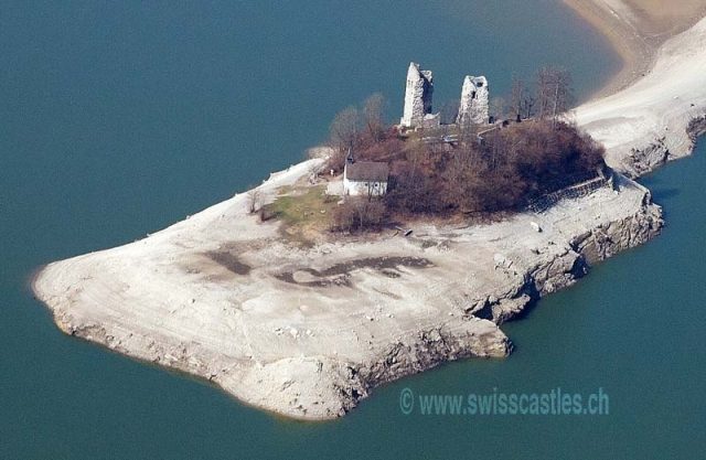
Ogoz Castle (Ruin) (Pont-en-Ogoz)

The remains of the Castle can be visited

At Pont there was one of the fords that connected the two Roman roads along the banks of the Sarine. A watchtower probably stood on the site of a medieval castle. The ford was replaced by bridges in the 12th century, which presumably gave the lordship its name. A first bridge was built below the village of Vieux-Châtel above the current ruin. A second was erected at the end of the Presqu'île. As these were too low, they were threatened by the floods of the Sarine, and so they were replaced by a third bridge, 200 m further up. This was mentioned in 1490, when Fribourg bought back the lordship, and was made of wood. In 1544 it was rebuilt in stone. Composed of three tuff arches, the "Bridge of Tusy" is still intact beneath the waters of the lake. A legend claims that it was the work of the devil, who built it in one night. As payment for his work, he demanded the soul of the first living creature to cross it. The governor of the village released a rat there at dawn, pursued by a cat. Furious at being tricked, the devil tried to destroy it by throwing a large stone at it – still recognizable nearby.

The Lordship
The lordship of Pont does not appear before the 12th century. The oldest charters mentioning the lordships of Pont date from 1179. Pont-en-Ogoz first fell under the influence of the Lords of Maggenberg, and the young city of Fribourg, founded in 1157. Then, from 1250, it was dependent on the House of Savoy, which maintained its influence over the lordship for two centuries. The family, which died out at the end of the 15th century, produced several monks of the Abbey of Hauterive and some canons in Lausanne. According to local custom, all its members exercised their feudal rights together. The lordship was thus the property of several lords, which naturally led to fragmentation.

Already in the 14th century, it was divided into several parts. Due to various inheritances in 1452, the family of Pont no longer held any rights. Its old lordship then passed into the hands of the families Mayor of Lutry, Challant and Prez. On November 19, 1482, Antoine de Menthon, whose family owned most of the village, sold all the rights he held there to Fribourg. Fribourg gradually bought back the remaining parts, and shortly after acquiring the entire lordship, established its first bailiwick here.

The Castle
Although the existence of the castle is first mentioned in 1231, its construction can be dated to the beginning of the 13th century. Despite the excavations and discoveries of 1946/47, it is not possible to say this precisely. The construction of the two watchtowers as well as other buildings, and even a fourth tower, may have been erected after the fragmentation of the territory into cooperative lordships.

Today, the original elevated entrance is clearly visible on each of the two towers. It is indeed common for the towers of castles to be accessible only by an external wooden staircase. On the largest tower to the south, the floors can be recognized thanks to the traces of the balconies and the visible floors in the wall.

A large part of the molasse and tuff stones from the exterior facade of the two towers was reused as construction material outside the site. Thus, only the lower parts of the buildings remain, which had remained inaccessible until the restoration. The different construction phases can be clearly recognized there. It is sufficient to compare the construction method of the walls of the two towers. One is thus amazed by the extraordinary presence of cavities in the form of channels in the south tower: in this place there were formerly beams that were inserted into the walls to give more strength to the freshly built walls.

Take Mobile History with you

You are reading this text for free. Premium adds what matters on the road: descriptions read aloud, sites found through your camera, whole regions taken offline.

  • Every description, including the ~17,700 Premium sites
  • Audio guide: have descriptions read to you on location
  • AR finder: see sites through your camera, with distance and bearing
  • Unlimited saved sites

14 days free, then from €2.99 a month. Cancel anytime.

Source: Wikipedia · Licence: CC BY-SA 4.0

This description draws on the facts documented in the linked Wikipedia article; Wikipedia content is licensed under CC BY-SA 4.0. Wording and editing: Mobile History.

Location: 46.6984, 7.1001