Uninhabited
Orr Castle (Ruin)

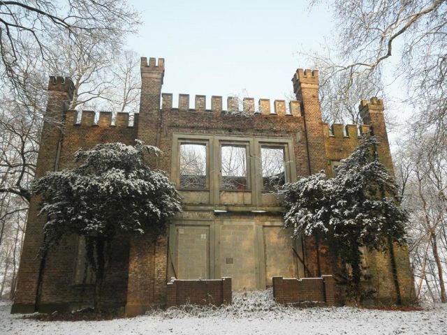
Haus Orr was a manor house in what is now Pulheim in the Rhein-Erft-Kreis in North Rhine-Westphalia. The building and the associated former farm estate Kriegshof are still in existence today.
Haus Orr and its former farm estate Kriegshof are set back from the country road between Pulheim and Esch.
The grounds of Haus Orr included a park with a pond, which had two islands of different sizes. The smaller island presumably once contained a castle complex.
In the first documented mention in 1264, Orr was referred to as "Urre". In the 13th century, a Jh. Friedrich von Gyltling was lord of Orr. In 1342, Gobelinus von Udenkovendem donated lands of the place to the convent of St. Severin.
From 1576, the Archbishop of Cologne and the Duke of Jülich Berg disputed sovereignty. Since they shared high and low jurisdiction, taxation of the Orr country people was temporarily not possible.
The two-story manor house was built around 1838 by the banker Peter Daniel Koch, according to plans by the Cologne cathedral master builder Ernst Friedrich Zwirner.
Koch's heirs sold the complex to Werner Pagenstecher.
After the war, the manor house was still inhabited, but was later abandoned and partially fell into disrepair, so that emergency stabilization had to be carried out to preserve the building.
The landscape park became overgrown and the pond systems dried out.
Complex+
The neo-Gothic secular building of the two-story manor house featured tower-like corner structures, which were intended to give the building the appearance of a mighty Gothic castle architecture.
The three-axis, south-facing bay window belonged to the main living area of the building. The servants' quarters, located behind a battlement, were formerly covered by a hip roof.
The construction of the building was first followed by the creation of a small park, which extended to the ponds located to the east.
Werner Pagenstecher had the small park expanded into a landscape park from 1887, the center of which was the smaller island located in the pond.
Take Mobile History with you
You are reading this text for free. Premium adds what matters on the road: descriptions read aloud, sites found through your camera, whole regions taken offline.
- Every description, including the ~17,700 Premium sites
- Audio guide: have descriptions read to you on location
- AR finder: see sites through your camera, with distance and bearing
- Unlimited saved sites
14 days free, then from €2.99 a month. Cancel anytime.
Source: Wikipedia · Licence: CC BY-SA 4.0
This description draws on the facts documented in the linked Wikipedia article; Wikipedia content is licensed under CC BY-SA 4.0. Wording and editing: Mobile History.
Location: 51.0070, 6.8283