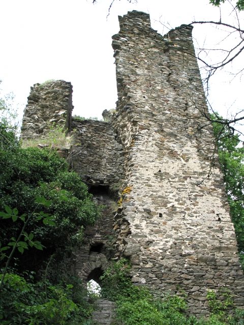
The remains of the Castle can be visited
Rheinberg Castle (Ruin) (Lorch)

Rheinberg Castle is the ruin of a hilltop castle above the Wisper Valley in western Hesse.
The castle complex is located in the area of the Central Hessian small town of Lorch. It is situated about 14 kilometers northeast of the town of Lorch, which lies on the Rhine, and about 3 kilometers southeast of the district of Ransel. Rheinberg Castle lies above the Wisper Valley at an altitude of 260 meters above sea level on a mountain spur (spur castle), which is separated from the neighboring ridges by the valleys of two smaller tributaries of the Wisper.
There are contradictory sources regarding the exact date of construction. Probably, an initial complex was built around the year 1165 by the then Archbishop of Mainz and was granted to the Rheingrafen as a Mainz fief in 1170. Waldemar Palasdies: Burg Rheinberg in Burgen im Rheingau - Beiträge zur Weinkultur 1997, Publisher Gesellschaft für Rheingauer Weinkultur mbH 1997. After a feud between Archbishop Weinher von Eppstein and Rheingraf Siegfrid von Rheinberg in 1279, the castle was besieged by the Mainz forces. For this purpose, Blideneck Castle, located about 500 meters north and slightly higher on the same mountain spur, was built as a counter-castle, as was the Aachener Schanze, located only 500 meters further west on an opposite ridge. In 1280, Rheinberg Castle was conquered and destroyed by the Mainz forces. Subsequently, a reconstruction took place until 1315, during which the current keep was also erected. In 1399, the castle became a Palatinate fief. From about 1400, the complex was expanded into a Ganerbenburg (jointly inherited castle) and inhabited by several families. In the following centuries, Rheinberg Castle, which had become strategically insignificant, was never again destroyed in military attacks; however, it was structurally neglected and eventually abandoned. Since the end of the 18th century, the castle was uninhabitable and increasingly fell into ruin.
The castle is characterized by the keep, standing on a rock base in the south of the ruin, which still has three floors and rises up to 13 meters high. The complex itself has a length of 60 meters and a width of a good 20 meters. Access leads from the north over the neck ditch and through the castle gate into the outer bailey. From here, the path continues into the inner castle courtyard with the remains of the castle well, which lies slightly below the outer bailey. Apart from the keep and the remains of the curtain wall, hardly any traces of the residential buildings are visible. The eastern flank of the castle was secured by a battery tower, which is now in danger of collapsing, but which was only built at a later date.
Today, the ruin is privately owned, but is freely accessible (as of December 2006). The complex is in danger of collapsing, and no securing or preservation measures are being carried out. It is located in a high forest, is not easy to find, and can only be reached via narrow and partly steep footpaths. The castle is neither inhabited nor does it contain a restaurant. Since the keep can no longer be climbed, there are no viewing opportunities.
Take Mobile History with you
You are reading this text for free. Premium adds what matters on the road: descriptions read aloud, sites found through your camera, whole regions taken offline.
- Every description, including the ~17,700 Premium sites
- Audio guide: have descriptions read to you on location
- AR finder: see sites through your camera, with distance and bearing
- Unlimited saved sites
14 days free, then from €2.99 a month. Cancel anytime.
Source: Wikipedia · Licence: CC BY-SA 4.0
This description draws on the facts documented in the linked Wikipedia article; Wikipedia content is licensed under CC BY-SA 4.0. Wording and editing: Mobile History.
Location: 50.0858, 7.8703