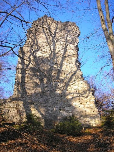
The remains of the Castle can be visited
Rundeck Castle (Ruin)

Rundeck Castle, also known as Erlingshofen Castle, Stossenberg, or Stossenburg, is a castle ruin near Erlingshofen in the municipality of Kinding in the Bavarian district of Eichstätt.
The ruin of Rundeck Castle rises east of Erlingshofen on the spur of the Schlossberg, a steep mountain tongue above the Anlauter valley.
Against the eastern plateau, an elaborate triple ditch and rampart system secures the castle site. The other flanks are protected by the natural steep drop and the inner ditch, which continues as a berm to the west.
Approximately 550 meters north-northwest of the ruin, another defensive structure, Burgstall Wieseck, has been preserved at the edge of the valley. There is also an early medieval or older section fortification on the immediately southern Kirchberg, and a little further to the west lies the ruin of Brunneck Castle.
The Old Erlingshofen Castle
The first Erlingshofen Castle was probably built in the 12th century. In 1129, the brothers Hadebrand and Gottfried von "Erlungeshouen" are listed in the foundation charter of Plankstetten Monastery. In 1169, Gottfried last called himself von Erlingshofen, as the family had in the meantime moved to Arnsberg above the Altmühltal. When "the von Arnsberg" then built their new castle in Heideck, the noble family first called themselves "von Heideck" in 1192. The abandoned, perhaps also destroyed, castle continued to belong to the Lordship of Arnsberg, which, however, had been sold by Heideck to Bavaria before 1305 and was sold by the Wittelsbachs to the Bishop of Eichstätt in 1473. In 1379 and 1381, documents refer to the former castle of Erlingshofen as "alter Burgstall" (old castle site).
The Stossenburg
In 1381, Paul Stosser erected a new castle on the foundations of the old Erlingshofen Castle, which was given the name "Stozzenberg" by the Bavarian dukes, who had the right to use the castle as a base in case of war. The Stossers were originally based in Bieswang as knightly servants of the Marshals of Pappenheim. In 1383, Hans Stosser, a cousin of the deceased Paul Stosser, sold the castle to Duke Stephan the Kneißel of Bavaria-Ingolstadt. In 1388, the latter pledged the castle, which is uniquely referred to as "die vesten Stolczenberg" at this time, as collateral for 500 guilders to Heinrich Absberger von Rumburg. In 1392, during the third Bavarian partition, the castle reverted to Duke Stephan III. He sold it in 1409 to the brothers Hans and Heinrich Absberger zu Rumburg to settle his debts with them. Heinrich and his wife Adelheid became the ancestors of a collateral line of the Schenken, who named themselves after the Stossenburg. After Heinrich's death, his nephews sold the castle in 1481 for the pledge sum of 500 guilders to the Prince-Bishop of Eichstätt, Wilhelm von Reichenau. To render the pledged object unusable for redemption, the Prince-Bishopric of Eichstätt allowed the castle to fall into disrepair. In 1504, it was found abandoned by Nuremberg scouts. In 1601, during the visitation of the Eichstätt Vicar General Vitus Priefer, stately remains were still visible. The name "Stossenberg" fell into oblivion; instead, the name "Rundeck" first appeared in 1801. It was not until 1932 that the ruin of Rundeck was recognized as the former Stossenburg.
Description+
The oval castle complex, 30 to 40 meters in diameter, is separated from the hinterland by a triple neck ditch system with ramparts that carried palisades. The outer fortification, with its staggered triple ditch system and outer ramparts, is reminiscent of early medieval defensive structures (Hungarian ramparts) and certainly dates back at least to the high medieval castle.
The innermost of the neck ditches, which is particularly deep, ran as a ring ditch around the entire castle.
In the southeast of the complex, one entered the castle via a gate path. The 1.50-meter-thick curtain wall of limestone rubble is preserved for about a third of its total length up to a height of approximately six meters as the western outer front. The original putlog holes in the masonry, where the scaffolding was anchored, are still clearly visible. These openings were deliberately left open to serve as scaffolding supports again during a later renovation. A battlement ran around the complex on the top of the wall, the setback of which is still partially preserved.
In the southeast stood the four-story gate tower, which may also have taken on the defensive and representative functions of a keep and was accessible via a bridge. In addition to the partially preserved south wall, remnants of the gate passage have also been preserved. Some ashlar blocks here still originate from the first castle complex, while the other wall remains largely date back to the late medieval Stossenburg. A bailey, where the economic buildings usually stood, is missing. Safeguarding of the ruin took place in 1938 and 1981.
Like the neighboring castles of Rumburg and Brunneck, Rundeck Castle, or Stossenburg, is also to be assigned to the rather rare building type of the shell keep castle.
According to a legend, a wire rope ran from Rundeck Castle to Brunneck Castle, with which the knights could give a signal for robbery when a hiker or a cart came along the path.
The freely accessible castle ruin is a station on the "Kinding Castle Trail," which was created by the municipality of Kinding in cooperation with the castle researcher and historian Helmut Rischert.
Take Mobile History with you
You are reading this text for free. Premium adds what matters on the road: descriptions read aloud, sites found through your camera, whole regions taken offline.
- Every description, including the ~17,700 Premium sites
- Audio guide: have descriptions read to you on location
- AR finder: see sites through your camera, with distance and bearing
- Unlimited saved sites
14 days free, then from €2.99 a month. Cancel anytime.
Source: Wikipedia · Licence: CC BY-SA 4.0
This description draws on the facts documented in the linked Wikipedia article; Wikipedia content is licensed under CC BY-SA 4.0. Wording and editing: Mobile History.
Location: 48.9922, 11.3092