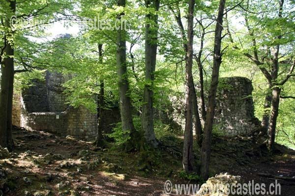
The remains of the Castle can be visited
Schalberg Castle (Ruin)

The castle ruin Schalberg is a ruin located 3 kilometers west of Aesch and 2.7 kilometers west of Pfeffingen in the area of the present-day municipality of Pfeffingen in the canton of Basel-Landschaft.
The Schalberg ruin is a significant remnant of a city noble's castle, situated on an elongated rocky ridge above the narrowest point of the Aesch Klusertal valley. It lies at an altitude of 444 meters, clearly visible in autumn (without leaves) from the country road to the west towards the hamlet of Tschöpperli. On the way up from the Klusertal valley to the Schalberg ruin, visitors also pass the prehistoric Schalberg cave and soon after reach two artificially excavated neck ditches. The limestone rock from the excavation of these neck ditches was used in the construction of Schalberg Castle.
The ruin is located on the access road to the Plattenpass, an important medieval traffic route between the Birseck and the Laufental. The immediate proximity of many other castles along this route suggests, however, that the motivation for its construction was probably not the collection of road tolls but rather rivalry with the Münch family.
Only 390 meters as the crow flies to the south-east lies Münchsberg Castle Ruin, which, like Schalberg, is also situated on a hilltop. Between the two lies the Engenstein ruin, which forms the predecessor of Schalberg and is only a mere 100 meters to the south-east. All three ruins are now somewhat hidden in the dense forest but are easily accessible via the Aescher Burgengratweg (Aesch Castle Ridge Trail). To the northwest of the Schalberg ruin, after a short hike, the Frohberg ruin - also called Tschäpperli or Tschöpperli - can also be visited.
Schalberg Castle consists of a two-part, good 100-meter-long complex comprising an upper castle and, to its northwest, a lower castle. The dimensions of the upper castle are still easily discernible today from the walls, up to 2 meters thick, around the round tower (almost 7 meters outer diameter, but due to the walls only about 3 meters clear width), while the extent of the lower castle can be recognized by the terraced areas. Several buildings stood in the castle, some of which are still recognizable by their wall remains; however, their function cannot be determined without precise excavation.
On the long sides of the elongated rocky ridge on which the ruin stands, there are steep rock faces. Approach from the southeast is made difficult by a natural depression in the terrain; to the northwest, two neck ditches were created as approach obstacles. The original access to the castle was from the east, led south of the round tower past the outside of the upper castle, and over a small gate ditch west outside the ring wall (today bridged with beams).
Several window openings have been incorporated into the south wall of the upper castle, about whose function and period of origin nothing can be said without a building archaeological investigation. Furthermore, a bricked-up wall passage is recognizable, which presumably led to a battlement that rested on beams, whose beam holes are still visible.
Schalberg Castle was built in the late 13th century by the Basel noble family Schaler: This is somewhat later than the neighboring castles Engenstein and Frohberg (also called Tschäpperli or Tschöpperli), which were also built by the Schalers. Carl Roth suspects that either Peter Schaler or his son Rudolf built the castle. The branch of the Schalers residing at Schalberg called themselves "von Schalberg". They built the castle on their own property. At the beginning of the 14th century, however, they handed the castle over to the Bishop of Basel and received it back as a fief: This was a common - though not necessarily voluntary - process at the time to secure the protection of a powerful ally within the medieval legal system. The complex was damaged in the earthquake of 1356 and subsequently repaired, but was probably abandoned shortly after 1400: At that time, political power had shifted from castles to cities. With the extinction of the Schaler family in 1437, the castle passed into the possession of the Counts of Tierstein: Their interest was probably less in the building fabric, which by then must have been very dilapidated, than in the rights associated with the complex (tax collection, jurisdiction, etc.). The last mention as a castle dates to 1452.
In 1975, the remains of Schalberg Castle were partially conserved but still await detailed excavation. Today, the ruin is the traditional home of the Schalberg scout group from Basel.
Take Mobile History with you
You are reading this text for free. Premium adds what matters on the road: descriptions read aloud, sites found through your camera, whole regions taken offline.
- Every description, including the ~17,700 Premium sites
- Audio guide: have descriptions read to you on location
- AR finder: see sites through your camera, with distance and bearing
- Unlimited saved sites
14 days free, then from €2.99 a month. Cancel anytime.
Source: Wikipedia · Licence: CC BY-SA 4.0
This description draws on the facts documented in the linked Wikipedia article; Wikipedia content is licensed under CC BY-SA 4.0. Wording and editing: Mobile History.
Location: 47.4646, 7.5680