RuinRamholz

Steckelburg Castle (Ruin) (Ramholz)
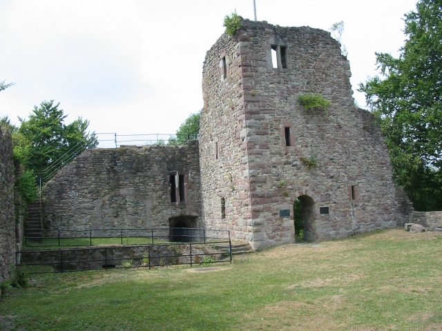
Steckelburg Castle (Ruin) (Ramholz)

The remains of the Castle can be visited

Steckelberg Castle is a castle ruin near Ramholz, a district of Schlüchtern in East Hesse, Germany.

The ruin of the former hilltop castle lies east of Vollmerz and northeast of Ramholz on a hilltop of a mountain spur on the eponymous Steckelberg.

The name of the castle goes back to the Middle High German term for "steep mountain" (Stechelnberc). As an imperial castle, the fortification served to protect the trade routes that led through the Bergwinkel. The Wine Route, running from Fulda to Franconia, led here over the ridge of the Breite First; this important north-south connection, known to ancient road research since Carolingian times, touches the fortification in its course between Veitsteinbach and Sterbfritz.

From 1131 to 1391, the Lords of Steckelberg had their ancestral seat on a nearby predecessor complex. This old Steckelberg Castle was located northeast of the current ruin on an offshoot of the Breite First, which is now known as Alteburgberg or Nickus. The baronial family Hermann von Steckelberg is mentioned around 1167. Between about 1240 and 1276, the castle must have been briefly in the possession of the Diocese of Würzburg. In 1274, Bishop Berthold II pledged the castle to Count Reinhard I (Hanau), whom he needed as an ally. In 1276, it was probably illegally occupied and used as a robber baron's castle. The castle was destroyed in 1276 on the order of King Rudolf I. On October 14, 1276, he passed judgment that Steckelburg should be torn down and never rebuilt without imperial permission. Allegedly, it posed a threat to the peace of the land; however, this measure probably served more to consolidate the possessions of the king's bailiff and confidant, the Count of Hanau, in this area. The Lords of Steckelberg, however, retained administrative and usage rights.

There are no further insights into the history of the old Steckelberg Castle. However, it is considered certain that this was not the oldest fortification at this location either: in 1969, the remains of a ring wall system covering approx. 0.38 hectares, dated to the Early Middle Ages, were discovered in the immediate vicinity.

In the middle of the 14th century, the family of Steckelberg died out in the male line, possessions and hereditary fiefs fell to the daughters or their husbands, among them Frowin von Hutten († 1377). He inherited, among other things, fields and meadows on the Steckelberg. Frowin's son Ulrich von Hutten († 1423) used this starting position to re-fortify the castle hill in 1388 and to build Steckelberg Castle at its present location. In formal legal circumvention of the royal prohibition, this fortification was built a few hundred meters away, above the predecessor building destroyed in 1276. This de facto breach of law remained unpunished, as Ulrich transferred the ownership rights of the castle back to the Bishop of Würzburg, thereby withdrawing it from the disposal of the actual territorial lords, namely the Counts of Hanau.

After Ulrich's death, the entire family was enfeoffed with Steckelberg Castle. In 1452, Lorenz von Hutten († 1498) concluded a castle peace with the other co-heirs, in which, in addition to the amount of joint maintenance payments and the supply of the castle in case of siege, it was also determined who could use the castle as a base for feuds under what conditions.

Despite the settlement, a dispute probably arose from 1452 between Hutten-Steckelberg and their liege lord Würzburg, when the latter wanted to include 32 outstanding co-heirs. In 1458, the castle was therefore besieged and finally conquered by Bishop Johann. Already in 1459,

however, after a settlement, he returned the castle. The partially destroyed castle was rebuilt or renovated and reoccupied.

On April 21, 1488, Ulrich von Hutten was born here. In a letter to Willibald Pirckheimer from 1518, he vividly - but probably exaggeratedly - described the conditions at his home castle.

In 1525, rebellious peasants stormed the Steckelberg, but failed. From the mid-16th century, the secondary residence in the village of Ramholz, located at the foot of the castle hill, gained importance for the owners. However, Steckelberg remained a defensive structure until the late 17th century, as the pledges during the Thirty Years' War clearly show. Philipp Daniel von Hutten († 1687) was the last noble inhabitant of the castle. A hand drawing from this period shows the building in its last phase of expansion, probably not significantly changed since 1509. Around 1700, the castle was already serving as a quarry. It can be assumed that it had already become uninhabitable during the Thirty Years' War.

In 1883, Baron Hugo von Stumm bought the ruin, thus saving it from further decay. He himself moved into the Hutten estate in Ramholz and expanded it into a magnificent castle complex in the Historicist style (→ Main article: Ramholz Castle).

In 2004, the current owner had the eastern wall of the castle renovated and the moat cleared. The ruin has recently been closed because parts of the north wall of the keep have collapsed.

Complex+

The ruin of the former castle complex has remnants of a rectangular curtain wall with a gun tower at the entrance in the west (modern built-in fireplace), a three-story keep in the northwest, and a cellar. In mid-2007, large parts of the walls collapsed.

Regarding the so-called Battery Tower: The thesis, uncritically copied ever since, states that Ulrich's father of the same name had the mighty powder or gun tower, which controlled access to the castle, built in 1509. However, masonry and loopholes clearly show that the tower dates from the construction period 1388/1389. The said door with the year 1509 is secondarily inserted. This year rather marks a conversion of the useless tower into a further residential building, which is proven by the architectural design of the door, the fireplace, and other details.

Take Mobile History with you

You are reading this text for free. Premium adds what matters on the road: descriptions read aloud, sites found through your camera, whole regions taken offline.

  • Every description, including the ~17,700 Premium sites
  • Audio guide: have descriptions read to you on location
  • AR finder: see sites through your camera, with distance and bearing
  • Unlimited saved sites

14 days free, then from €2.99 a month. Cancel anytime.

Source: Wikipedia · Licence: CC BY-SA 4.0

This description draws on the facts documented in the linked Wikipedia article; Wikipedia content is licensed under CC BY-SA 4.0. Wording and editing: Mobile History.

Location: 50.3372, 9.6206