RuinFriedlingen

Stein Castle (Ruin)

Stein Castle (Ruin)

The remains of the Castle can be visited

The castle ruin, known as Burgstall Stein, is located approximately 1000 meters southeast of the town church of Fridingen an der Donau in the district of Tuttlingen in Baden-Württemberg.

The ruin of the spur castle rises to an elevation of 755 m a.s.l., about 140 meters above the Danube valley. It is situated on a rock outcrop protruding from the valley slope, in the immediate vicinity of the Stiegelesfels castle ruin and the eponymous Kammfelsen in the local nature reserve, as well as the Burgstallhöhle, a cave castle.

The construction of Burg Stein is dated, based on ceramic finds and structural analysis of the still-preserved remains of the keep, to the period between 1100 and 1150. It probably originated as a successor to the earlier castle in the Burgstallhöhle. Nothing is known about its builders due to a lack of written sources. The castle was abandoned in the second half of the 13th century.

Presumably, the abandoned castle fell to the Duchy of Austria in 1381, which at that time acquired possession of the Lordship of Hohenberg. In 1409, Austria granted the Burgstall as a Hohenberg fief to Hans von Wildenfels. At that time, it was stated: "Hans von Wildenfels received on Saturday after St. Agnes' Day the Burgstall called Stein, at Fridingen and Kallenberg on the Danube, and a farm there, at this time the Walch and fields, meadows, fisheries and all appurtenances". This is also the first and only mention of the castle, although it is by no means certain whether it was this particular castle complex. Other abandoned and nameless castle sites with a nearby farm are known in the area around Fridingen and Kallenberg Castle with the cave castles Ziegelhöhlenburg, the cave castle near Scheuerlehof, and the neighboring Burgstallhöhle, as well as the castle sites on the Rockenbusch and on the neighboring Stiegelesfels. The ancestral castle of Hans von Wildenfels, Wildenfels Castle, has also not yet been localized.

Description+

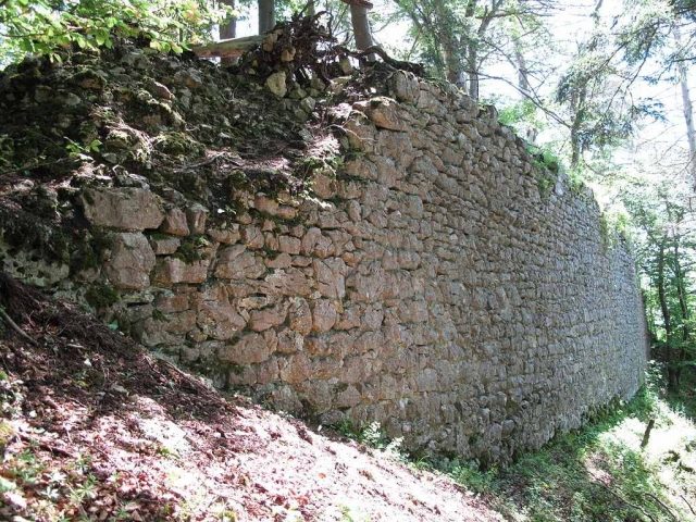
Of the castle, essentially an impressive approximately 32-meter-long and up to 6-meter-high remnant of the western enceinte wall and the inner wall shell of the keep (interior: 3 x 2.5 meters and approx. 2.5 meters high) are preserved. The approximately 20 x 60 meter castle area on the castle rock was separated from the valley slope by a roughly 10-meter-deep, horseshoe-shaped ditch. Outlines of a palas (approx. 12 x 9 meters footprint) are still recognizable. Roughly hewn corner stones have been preserved from its northeastern outer corner.

The ruin is now owned by the municipality of Fridingen.

Take Mobile History with you

You are reading this text for free. Premium adds what matters on the road: descriptions read aloud, sites found through your camera, whole regions taken offline.

  • Every description, including the ~17,700 Premium sites
  • Audio guide: have descriptions read to you on location
  • AR finder: see sites through your camera, with distance and bearing
  • Unlimited saved sites

14 days free, then from €2.99 a month. Cancel anytime.

Source: Wikipedia · Licence: CC BY-SA 4.0

This description draws on the facts documented in the linked Wikipedia article; Wikipedia content is licensed under CC BY-SA 4.0. Wording and editing: Mobile History.

Location: 48.0150, 8.9408