RuinBad Soden

Stolzenberg Castle (Ruin) (Bad Soden)
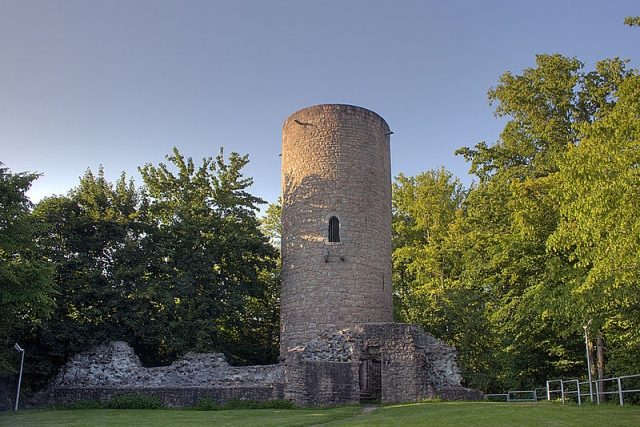
Stolzenberg Castle (Ruin) (Bad Soden)

The remains of the Castle can be visited

Stolzenberg Castle is a castle ruin near Bad Soden, a district of Bad Soden-Salmünster in East Hesse, Germany.

The ruin of the former hilltop castle is located northeast of Bad Soden on a spur of the 277 m high "Stolzenberg" of the same name.

The founding date of Stolzenberg Castle can no longer be determined from written records. It is possible that a first fortification was already built in the 11th/12th century. The favorable location makes this probable: the castle was situated directly above an old long-distance trade route, the Via Regia, which is still recalled by the name "Maustor" (a corruption of Mauttor, meaning toll gate) for a now demolished city gate at the foot of the castle hill.

However, a protective function of the early defensive structure in relation to the brine springs in the Salztal is not confirmed.

Stolzenberg is first mentioned by name in a document from King William of Holland from 1252. In it, the abbot of Fulda Monastery, Heinrich IV von Erthal, is granted permission to rebuild the castle, which had been destroyed shortly before (nostris diebus) by "enemies of the church" (inimicos ecclesie). The wording suggests that the castle fell victim to an attack by excommunicated individuals, although their identity is disputed. The Counts of Rieneck, whose attempts to conquer possessions in the Kinzig Valley are documented for the period between 1230 and 1250 and who were excommunicated in 1243 for attacks on Schlüchtern Monastery, could be considered. But Archbishop Gerhard von Dhaun of Mainz could also have had an interest in the destruction of the castle: the Mainz possessions in Salmünster were in the immediate vicinity of Stolzenberg, which could lead to long-term conflicts. In addition, Gerhard also fell under the church ban after 1250 due to his rule and loyalty to the Staufer party. The confirmation of property rights by the king, which was quite unusual for this period, in any case points to previously existing disagreements. It also underlines the political alliance between the Fulda abbot and William, who was (also for this reason) reviled as the "priest king".

Probably after 1252, the keep was rebuilt and the entire complex was expanded in stone. It remains unclear whether the curtain wall was already extended in this phase and led around the suburbium (=outer bailey) that had developed at the foot of the castle hill. For this settlement, the Fulda abbot obtained city rights from King Adolf of Nassau in 1296. However, the place named Stolzenthal in the document eventually adopted the name of the incorporated salt boiler hamlet of Sod(en).

In 1299, a Hermann von Hutten appears as "officiatus in Stolczenberg". He is an early representative of the later important noble family of Hutten, who administered the castle fief as a Vogt, probably on behalf of the Lords of Hanau.

In 1319, the castle chapel was (re?) consecrated. It was also visited by the inhabitants of Stolzenthal, for whom, however, some time later a separate church was built on the slope, halfway between the castle and the town - "for convenience", as it says in a letter from Pastor Martin Göbel from 1597. As late as 1335, a vineyard was laid out around the chapel. This older building was replaced in 1896 by St. Laurentius Church.

In the following period, the Stolzenberg castle fief was the object of extensive exchange and re-exchange actions, in the course of which the von Hutten family gradually established itself firmly in the castle. At the latest since the 15th century, the branch of the family residing here has carried the name suffix "zu Stolzenberg". However, the castle visibly fell into disrepair - in 1512, part of the Kemenate collapsed, another building had to be completely rebuilt in 1519.

Frowin von Hutten's involvement in the so-called "Knights' War" on the side of Franz von Sickingen also proved detrimental: opposing troops under Philipp von Hessen advanced against Frowin's ancestral seat on October 24, 1522, and shelled Stolzenberg until it was ready for storming on the same day. Despite some repair work in the following years, Lucas von Hutten finally moved his residence around 1536 to the new Huttenschloss located downstream, which was probably built on the site of an older farm belonging to the castle.

As late as 1597, however, the Huttens held Protestant services in the castle chapel - which aroused the displeasure of the Catholic priest Göbel, who reported on this incident. The last attested inhabitant of Stolzenberg was the castellan Cord Gaull, whose children were born in the castle until 1609 according to the church register. Another son was then born in 1611 in the neighboring Eckardroth.

In a donation from 1734, there is only talk of a "ruined castle Stoltzenberg". The buildings were largely demolished and the stones used for constructions in the surrounding area. At the end of the 19th century, a dance hall was built below the plateau that formed the castle courtyard, which additionally changed the shape of the castle hill.

In 1970, the remains of the rising masonry were secured and the keep was converted into an observation tower, which has since been marketed as a landmark of the spa town of Bad Soden.

Layout+

The ruin of Stolzenberg Castle is freely accessible. It consists of a keep about twenty meters high, which unusually protects the attack side of the fortification. The former entrance at a height of about ten meters, which could only be reached via a staircase, is still visible, but the modern observation platform is accessed via a ground-level entrance. A larger piece of wall, which probably formed the substructure or the back wall of earlier buildings in the castle courtyard, is located in front of the tower. The curtain wall once encompassed the entire castle plateau; its course is now only indicated by the surrounding double ditch.

The keep is also used today by a professional climbing school as a training tower for industrial climbers and high-altitude rescuers.

Take Mobile History with you

You are reading this text for free. Premium adds what matters on the road: descriptions read aloud, sites found through your camera, whole regions taken offline.

  • Every description, including the ~17,700 Premium sites
  • Audio guide: have descriptions read to you on location
  • AR finder: see sites through your camera, with distance and bearing
  • Unlimited saved sites

14 days free, then from €2.99 a month. Cancel anytime.

Source: Wikipedia · Licence: CC BY-SA 4.0

This description draws on the facts documented in the linked Wikipedia article; Wikipedia content is licensed under CC BY-SA 4.0. Wording and editing: Mobile History.

Location: 50.2910, 9.3681