RuinStromberg

Stromberg Castle (Ruin)

Stromberg Castle (Ruin)

Museum

The Castle can be visited

The ruin of Stromberg Castle is located in the Stromberg district of the city of Oelde in the Warendorf district in North Rhine-Westphalia.

According to legend, Stromberg Castle in Westphalia dates back to a foundation by Charlemagne around the year 800, who founded several monasteries nearby (Liesborn, Herzfeld) and had several castles built for their protection.

The first documented mention of the castellans of Stromberg occurred in 1177.

In a document from Bishop Hermann of Münster, Castellan Othalrich and his wife Gisla appear. In this document - after the death of their son Gottfried I. - Stromberg Castle is given as a fief to their grandchildren, the children of their daughter Gisla, Hermann II. and Heinrich I.

Stromberg Castle belonged to the Bishop of Münster and served to protect the southeastern borders of the Diocese of Münster.

From 1177 to 1463, Stromberg Castle was managed by the castellans of Stromberg from the Rüdenberg family.

From 1463 (with the extinction of the castellans of Stromberg), Stromberg Castle reverted to the Bishop of Münster.

In 1344, the Gothic Cross Church was consecrated inside the castle, where the Holy Cross of Stromberg is venerated.

Stromberg Castle became the seat of the Stromberg office. From 1780, Stromberg Castle was demolished by order of the Elector and Bishop Maximilian Franz. Today, mighty ruins still bear witness to the castle.

The Castle+

Stromberg Castle in Westphalia was built at a strategically favorable location on a hill in the Beckum Hills. It is thus the only hilltop castle in Münsterland, after Cappenberg was converted into a monastery.

First documented mention of the castellans of Stromberg in 1177, although it must be assumed that Stromberg Castle had existed for longer. It probably dates back to the time of Charlemagne, who founded a monastery in Liesborn.

The view to the east extends far into the Paderborn region (on days with good visibility, the cement works of Geseke and Erwitte can be recognized as landmarks), to the south the view reaches the Haarstrang ridge.

Due to this location, Stromberg Castle was ideally suited to defend the eastern borders of the Diocese of Münster.

Steep slopes to the south and west provide natural protection against attackers, reinforced by thick walls. To the east and north, the castle was protected by a double wall with a moat in between.

The extent of the castle, with an almost triangular layout, was approximately:

  • to the south 230m
  • to the west 285m
  • to the north 50m
  • to the east 180m

and formed a total area of approx. 30,000 m². The surrounding wall was thus approx. 745m long!

The highest point of the castle is at the Cross Church and is 154.59m/NN, while the rest of the castle complex has a height of approx. 151.15m/NN.

The castle was entered from the current Münsterstraße via a tower located in front of the Paulusturm. The Paulusturm itself was further protected by a drawbridge.

Through this gate system, one reached the first of the three castle courtyards, the Burgmannenhof. There, the first thing that catches the eye is the Cross Church, built in the 12th century.

Through a second archway, guarded by 2 guardhouses, one reached the castle courtyard in the southern part of the castle complex. The third smaller courtyard occupied the western side in the southern part of the castle and was probably referred to as the official square.

Several wells supplied the castle inhabitants with water.

One of them is located between the Paulusturm and the Cross Church. It is approx. 30 m deep. For comparison: The Paulusturm is approx. 30 m high.

The residential houses of the castle knights and the castellan were located in the individual courtyards.

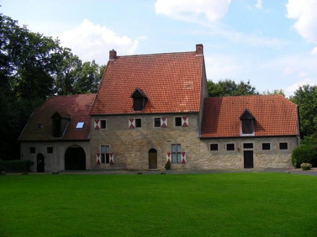
The Mallinckrodthaus, located on the left side of the Burgmannenhof, still gives an impression of what the houses looked like at that time.

The castellan's residence, the so-called Palas, was located on the southern castle wall. Several watchtowers were located along the castle walls.

Take Mobile History with you

You are reading this text for free. Premium adds what matters on the road: descriptions read aloud, sites found through your camera, whole regions taken offline.

  • Every description, including the ~17,700 Premium sites
  • Audio guide: have descriptions read to you on location
  • AR finder: see sites through your camera, with distance and bearing
  • Unlimited saved sites

14 days free, then from €2.99 a month. Cancel anytime.

Source: Wikipedia · Licence: CC BY-SA 4.0

This description draws on the facts documented in the linked Wikipedia article; Wikipedia content is licensed under CC BY-SA 4.0. Wording and editing: Mobile History.

Location: 51.8000, 8.2033