RuinUlrichstein

Ulrichstein Castle (Ruin)

Ulrichstein Castle (Ruin)

The remains of the Castle can be visited

Ulrichstein Castle (614 m) is located in the northwestern part of the Vogelsberg and is visible from afar across the plain. On its summit stand the remains of Ulrichstein Castle from the 12th century, which once served to protect important trade routes. At the foot of the castle hill lies the town of Ulrichstein, the highest town in Hesse.

The Ulrichstein Castle Hill is a former basalt pipe of the Tertiary shield volcano Hoher Vogelsberg, which formed about 19 million years ago. Through this pipe, lava rose from the Earth's interior. As almost everywhere in the Hoher Vogelsberg, the basalt, whose distribution area is a total of 2,500 km² and in some places up to 300 m deep, is largely not on the surface here either, but under weathered loam and loess.

The initial ownership is unclear; it is possible that the castle came to the Landgraviate of Hesse via Büdingen and the noble family Breuberg. It is certain that a document from 1296 identifies the forest of Ulrichstein as the property of Heinrich I of Hesse. In the 14th century, this property came as a fief to the Lords of Eisenbach, who heavily fortified and expanded the castle.

The Lords of Eisenbach were followed by the Barons of Riedesel as landgravial hereditary marshals and rent officials. They also used the outwork below the castle hill - basalt buildings from 1464 still preserved today - for collecting road tolls and the "tithe" as well as exercising jurisdiction until the end of the Old Empire in 1806.

The castle hill was always a contested area in the various wars. A memorial plaque at the entrance commemorates soldiers of the Seven Years' War buried here. In the western area of the castle grounds are war cemeteries with graves from the First and Second World Wars.

Between 1991 and 2005, a local non-profit support association carried out extensive restoration work and tourist documentation on the castle ruins.

The Castle Complex+

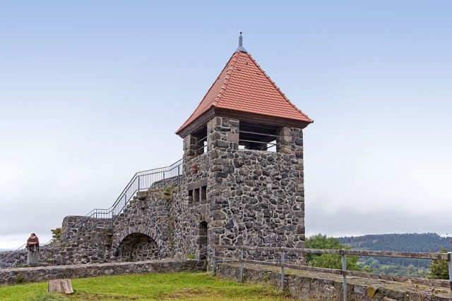
Despite the restorations, the structure of the complex is only rudimentarily recognizable. There was an inner castle wall (renovated in the early 1990s) and an outer one (renewed in 2000) with a defensive tower that was converted into an observation tower in 2004/2005. In the south of the area, the foundations of stables and outbuildings as well as the castle chapel have been uncovered, and a cistern was discovered in 2003. The remains of the palas within the core castle were restored in the mid-1990s.

A small herb garden in the shape of a Latin cross was laid out in 1999 in the style of historic monastery herb gardens.

Take Mobile History with you

You are reading this text for free. Premium adds what matters on the road: descriptions read aloud, sites found through your camera, whole regions taken offline.

  • Every description, including the ~17,700 Premium sites
  • Audio guide: have descriptions read to you on location
  • AR finder: see sites through your camera, with distance and bearing
  • Unlimited saved sites

14 days free, then from €2.99 a month. Cancel anytime.

Source: Wikipedia · Licence: CC BY-SA 4.0

This description draws on the facts documented in the linked Wikipedia article; Wikipedia content is licensed under CC BY-SA 4.0. Wording and editing: Mobile History.

Location: 50.5764, 9.1900