Museum
Alt Ranft Castle
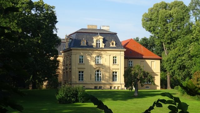
The first manor house was built around 1600. In 1652, Jacob von Pfuhl sold the estate to Wolf Friedrich von Bomsdorf. Under his rule, initial land improvement works took place, and in 1678, the manor house was converted into a baroque castle.
In 1739, ownership of the estate was transferred to Privy Councillor of Finance Samuel von Marschall. He advocated to Frederick II for the drainage of the Oderbruch, which then took place from 1747 to 1762 under Marschall's leadership. With the drainage, fishing as a livelihood for the inhabitants of Altranft disappeared. It was replaced by now profitable agriculture.
In 1820, Heinrich August von Marschall sold the estate to Count Wilhelm Werner Georg von Hacke. The estate then remained in the possession of the Counts von Hacke until 1916. With the acquisition of the estate, Count Hacke began to design the 3.5-hectare castle park under the influence of Peter Joseph Lenné. In 1878, under Edwin Graf von Hacke, the single-story annex of the castle, built in 1724, was demolished and replaced by a new building with two side wings. This gave the castle its present appearance.
In 1916, the estate was bought by Heinrich Wertheimer, who, however, sold it in the same year to Carl Eschenbach. The Eschenbach family, consisting of the merchant Carl Eschenbach (* March 3, 1879 Elberfeld; † February 1945), his wife Else (* April 2, 1900 Berlin; † February 1945) and children Carla (* March 1, 1928; † January 21, 1943) and Carl-Adolf (* 1929) led the estate and the village to new prosperity. Through the re-cultivation of the estate and its associated lands, over 100 employees were at times in the service of the Eschenbach family. After the suicide of the Eschenbach couple in February 1945, the estate was confiscated by the Russian army during their crossing of the Oder and became public property after the founding of the GDR.
After 1945, Altranft was located in the Soviet occupation zone. Initially, resettlers moved into the castle. The agricultural areas of the estate were distributed as part of the land reform to 18 farm laborers, 73 smallholders, 50 resettlers, and one farming family. In 1949, the castle became the property of the state of Brandenburg. After the resettlers moved out, it then housed, partly simultaneously, partly successively, a school, a school after-school care center, a day nursery, a restaurant, a library, or was used as a cultural center.
Brandenburg Open-Air Museum Altranft+
In the 1970s, work began on establishing a museum on the agricultural history of the village, which today, as the Brandenburg Open-Air Museum Altranft, has supra-regional significance. The buildings of this museum include, in addition to the castle, numerous other restored buildings in the village, such as a middle-class farmhouse, in which an old school was set up, a fisherman's house from 1700, a washhouse and bakery from 1880, and the forge from 1910.
In the castle, in addition to an exhibition of Gründerzeit interiors, there are also permanent exhibitions on building and settlement history and the drainage of the Oderbruch. In addition, there are regular special exhibitions.
During the summer half-year, the museum offers active learning of old craft activities such as blacksmithing, bread baking, pottery, or spinning on several action days. As part of a museum education program, school classes from the surrounding area can also carry out these activities during the week.
Take Mobile History with you
You are reading this text for free. Premium adds what matters on the road: descriptions read aloud, sites found through your camera, whole regions taken offline.
- Every description, including the ~17,700 Premium sites
- Audio guide: have descriptions read to you on location
- AR finder: see sites through your camera, with distance and bearing
- Unlimited saved sites
14 days free, then from €2.99 a month. Cancel anytime.
Source: Wikipedia · Licence: CC BY-SA 4.0 · Image: Jörg Heldt
This description draws on the facts documented in the linked Wikipedia article; Wikipedia content is licensed under CC BY-SA 4.0. Wording and editing: Mobile History.
Location: 52.7696, 14.0852