To be privately owned
Bruchhausen Castle

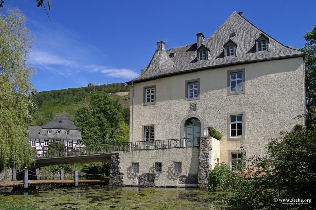
Bruchhausen Castle is a noble residence in the southeastern urban area of Olsberg in Sauerland, North Rhine-Westphalia (Germany). Bruchhausen Castle is located in Bruchhausen (southeastern district of Olsberg) in the valley of the Medebach, a headstream of the Gierskoppbach. It was built on the western slope of the Istenberg (721 m above sea level) or west below the Bruchhauser Steine at an altitude of approximately 450 m.
Originally, the complex was owned by the Lords of Bruchhausen. After their extinction, the property passed to the Gaugreben family in the 15th century. Around 1550, a castle complex was added to the residential tower dating from the 14th century and expanded in the following centuries. The three-story building is located within a small park. The complex is surrounded by a moat. Two bridges lead over it to the castle. The meter-thick masonry and the partially 10 m wide moat suggest an originally castle-like complex. A drawbridge was only replaced by a stone bridge in 1898. The outbuildings are located in the area of the former outer bailey. Among them is the Rentamt (steward's office) built in 1788. A wall encloses the outer bailey. Formerly, a chapel was attached to it, but it was demolished in the 19th century.
At the beginning of the Revolution of 1848/49, numerous inhabitants of the village of Bruchhausen marched to the castle, singing freedom songs, shouting for freedom and justice, and demanding "free wood and free pasture." The Rentamt building was stormed, files and account books were burned, windows and furniture were smashed. A few days later, the unrest was ended by Prussian military.
The castle remained in the family possession of the von Gaugreben family until 1937. After the death of the last owner, it came into the possession of Baron Ferdinand von Lüninck by inheritance. He was executed in connection with the assassination attempt of July 20, 1944. Through his daughter, the castle came into the possession of the von Fürstenberg family.
Architecture+
The manor house is a compact plastered building on a high plinth. The outline is irregular. The short north wing with a half-timbered gable and a slightly recessed corner building to the northwest is heightened like a tower by a tent roof. The complex was heavily reshaped internally and externally by numerous alterations in the 19th and 20th centuries. Above the portal and on the tower plinth, there is a coat of arms of the Gaugreben family.
Rentamt
The Rentamt is a half-timbered house with dormers and a mansard hip roof. The solid rear side is dated 1788. The left-hand extension dates from a later period. The corner posts are decorated with carved spiral columns, and the door frame is carved.
Dairy Farm
The so-called dairy farm is an elongated half-timbered outbuilding. It has a half-hipped roof. The rear extension dates from the 19th century.
Nowadays+
The estate, owned by Baron von Fürstenberg-Gaugreben, now includes the castle with a moat, the Rentamt, the dairy farm, and in particular a carriage museum. Documents dating back to the 13th century are kept in the Rentamt's archive. The dairy farm houses a farm brewery and an estate tavern. Bornsteiner Landbier is brewed in light and dark varieties, as well as other types. Only an external viewing of the castle itself is possible. From the estate, 700 hectares of forest are managed, and products include wood, Christmas trees, and game meat.
Take Mobile History with you
You are reading this text for free. Premium adds what matters on the road: descriptions read aloud, sites found through your camera, whole regions taken offline.
- Every description, including the ~17,700 Premium sites
- Audio guide: have descriptions read to you on location
- AR finder: see sites through your camera, with distance and bearing
- Unlimited saved sites
14 days free, then from €2.99 a month. Cancel anytime.
Source: Wikipedia · Licence: CC BY-SA 4.0 · Image: http://www.zeche.org/
This description draws on the facts documented in the linked Wikipedia article; Wikipedia content is licensed under CC BY-SA 4.0. Wording and editing: Mobile History.
Location: 51.3201, 8.5300