To be privately owned
Courgevaux Castle

The patrician area consisted of the estates and rights owned by the Fribourg family von Praroman in the 15th and 16th centuries. Rudolph in 1492, Humbert and his son Sebold in 1529 are worth mentioning. In 1548, Sebold transferred his property rights to his mother Bernhardine, née von Vuippens. Petermann von Praroman sold the property in 1576 to Hans Lando von Murten, who sold it the following year to Hans Erhard von Freiburg. It seems that Hans Erhard directly transferred it to Jean Jacques von Diesbach (from Bern), whose name appears twice in 1605 and 1610 as an important owner of Courgevaux. Jean Jacques died in 1627 and the ownership of rights and estates of Corgevaux returned to the Diesbach Liebistorf branch. In 1713, the Glarus merchant Balthasar Rosenberg acquired the legacy of a part of the territory, including the recently built manor house. Rosenberg, burdened by debts, was soon followed in 1722 by the Fribourg Jean-Frédéric von Diesbach (1677-1751), a well-known high officer in the service of the Austrian Empire. Since the prince died childless, the property passed to the Diesbach-Torny branch of the family, who owned the house until 1918. From 1867, they no longer lived there and had made it available to a boarding school for young English people. After its sale to the municipality (1918), the manor house temporarily served as a rental building. It became private property again in 1927; the Raaflaub family has lived there since 1957.
Construction
In 1684, Madeleine von Diesbach, née Marcuard, widow of Gérard von Diesbach (1620-1680), had the construction built on a still free plot of land, which became the oldest element of the current manor house. The farmers came to her aid to erect the framework and were rewarded for their efforts with a feast.
The extensions in the 1790s
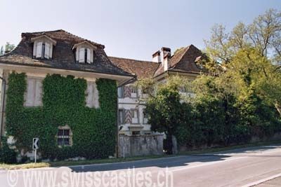
The current building consists of the extension commissioned by Francois Pierre von Diesbach (1739-1811) to have more spacious apartments. The work was carried out from 1794 according to the plans of the Fribourg architect von Castella (1737-1823). The stones were transported by ship from the quarry of Jakob Grosse in Cressier as early as 1792. In parallel, materials from the neighboring watchtower, which was completely demolished, were used. The scaffolding was erected in July 1794. The names of the craftsmen responsible for the construction site are not known to us. The old manor house, with the exception of the latrines, which were demolished, was extended to the east, reconnected to the oven - which gives the whole its current asymmetrical U-shape and connects it with the adjacent constructions under the same hip roof. The new south facade, thus enlarged, became the main facade. The extension work was carried out in stages until 1798.
In 1810/11, the interior was furnished, as was the small French garden in front of the south facade, which was extended to the west. It is unclear whether the chapel, whose construction date of 1810 is known, was set up in the same building, or whether it was separate from it. The bird's-eye views painted in 1808 by the Fribourg painter Joseph von Landerset offer us a faithful picture of the whole, as it looked from the east and south. The actual manor house remained, but the original room layout was sacrificed during the complete renovation in 1959-1961 and in 1963-1965, which was led by the architect Alfred Schatzle, from Bern, to set up several apartments there. The house had lost all its furniture in 1867 and in 1918.
The barn, which already stood in the west corner of the quadrangle in the tithe plan of 1718, was demolished in the 1930s to allow for an improvement of the roadway. The old pavilion, which leaned against the eastern wall of the garden around 1840, served as a chapel for the Catholic community of Murten between 1848 and 1857. The building itself, repurchased by the municipality, was demolished in 1917. The greenhouse, which stood between the manor house and the barn and was mentioned from 1834, was destroyed shortly thereafter in 1917. It was a rectangular stone construction of 12 by 5 meters. The old brickworks at the southwest corner, however, remained.
Take Mobile History with you
You are reading this text for free. Premium adds what matters on the road: descriptions read aloud, sites found through your camera, whole regions taken offline.
- Every description, including the ~17,700 Premium sites
- Audio guide: have descriptions read to you on location
- AR finder: see sites through your camera, with distance and bearing
- Unlimited saved sites
14 days free, then from €2.99 a month. Cancel anytime.
Source: Wikipedia · Licence: CC BY-SA 4.0
This description draws on the facts documented in the linked Wikipedia article; Wikipedia content is licensed under CC BY-SA 4.0. Wording and editing: Mobile History.
Location: 46.9062, 7.1121