CastleWesseling

Eichholz Castle (Wesseling)
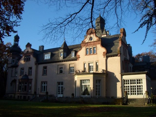
Eichholz Castle (Wesseling)

Foundation

Today, the Konrad Adenauer Foundation operates an educational academy in Eichholz Castle.

History of the Castle of Wesseling+

Near Urfeld (a district of Wesseling), i.e., on the current site of "Eichholz Castle," a Benedictine convent owned land and primarily engaged in timber production there. The St. Lubentius Abbey in Dietkirchen then had a part of this forest, which mainly consisted of oak trees (hence probably the name Eichholz, meaning "oak wood"), cleared and a farm built. This was first mentioned in 1320 ("Eycholtz"). The farm was subsequently expanded and enlarged; it remained in the possession of the abbesses of Dietkirchen.

From 1464, the abbesses changed the management of the farm and leased it to so-called "Halbmänner" (sharecroppers). During the Thirty Years' War, the farm was severely damaged and partially destroyed.

From 1794, the farm was under French administration and was called Michelshof from that time on. In 1807, it was auctioned for 18,700 francs to the broker Boismard. The further ownership development is unknown until 1821, when Michael Bütz acquired it. In 1822, most of the farm burned down.

J. G. Freiherr von Carnap, the new owner of the farm, rebuilt it, with a significant enlargement of the footprint. Among other things, he built a country house, which is still part of the "castle" today.

In 1854, it was sold to Privy Councillor H. Nasse, in 1865 to Paula Countess von Fürstenberg, and in 1888 to Carl Joest. He expanded the farm with additional land and developed it into a representative estate. Since then, the Eichholz estate has been popularly known as "Eichholz Castle." In 1955, the predecessor of the Konrad Adenauer Foundation, the "Society for Christian-Democratic Educational Work," acquired the estate. The foundation has operated an educational center there since 1956.

Villa Rustica near Eichholz Castle+

In 1986, foundations of a Roman villa were uncovered in the Wesseling-Eichholz industrial area. Remains of a burial ground and a water pipe, as well as household items, were also found.

Take Mobile History with you

You are reading this text for free. Premium adds what matters on the road: descriptions read aloud, sites found through your camera, whole regions taken offline.

  • Every description, including the ~17,700 Premium sites
  • Audio guide: have descriptions read to you on location
  • AR finder: see sites through your camera, with distance and bearing
  • Unlimited saved sites

14 days free, then from €2.99 a month. Cancel anytime.

Source: Wikipedia · Licence: CC BY-SA 4.0

This description draws on the facts documented in the linked Wikipedia article; Wikipedia content is licensed under CC BY-SA 4.0. Wording and editing: Mobile History.

Location: 50.8013, 6.9884