The Castle can't be visited
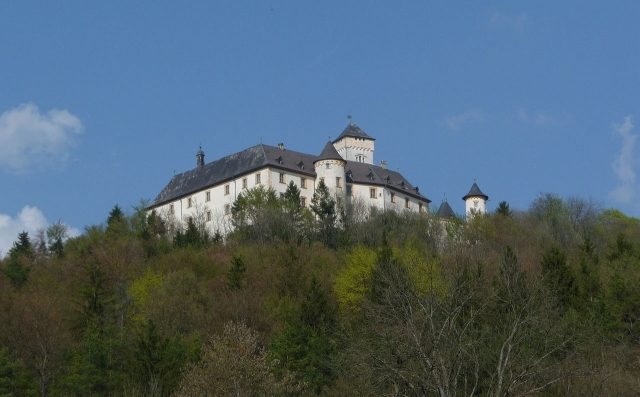
Greifenstein Castle

Greifenstein Castle has been owned by the Counts of Stauffenberg since 1691. It is located in Franconian Switzerland and is a district of Heiligenstadt in Upper Franconia. Today, Greifenstein has 11 inhabitants.
Description+
The driveway, coming from the east, leads around a small artificial hill crowned by a round temple of Ceres, into a long avenue lined with 300-year-old linden trees. It leads straight to the castle gate. To the right, one passes the manor farm, to the left, the kennels of the Irish Terriers.
The entire castle hill, now densely forested, was cleared in the Middle Ages and used for agriculture, also to allow the castle lords a clear view of approaching enemies.
The entrance to the castle forecourt leads over the former drawbridge, which is flanked by standing stone lions, the left one presenting the Stauffenberg coat of arms and the right one the Trockau coat of arms. The pointed arch gate at the end of the former drawbridge is the only entrance to the castle. Above the gate are the Stauffenberg coat of arms and a defensive oriel.
Behind another archway in the castle courtyard lies the Catholic castle chapel, dedicated to Saint Sebastian. Above the portal is an inscribed band with a Latin inscription:
„VlrtVs DeILLo eXlbat - aC sanabat oMnes Luc. 6“.
Translated, the inscription means:
„Power went out from him and healed all.“ (Luke 6, 19).
This inscription is a chronostichon and yields the year 1691.
In the inner courtyard, there is a 92-meter-deep draw well, which was driven through the rock by miners from Mainz in 1691.
Parts of the castle with a large collection of hunting weapons and trophies are also accessible to visitors. The exhibits bear witness to the importance of hunting and poaching in earlier times.
In a report from the time of the romantic discovery of Franconian Switzerland, Dr. Gottlieb Zimmermann describes a hiking route along the Leinleiter in 1840, also depicting Greifenstein Castle:
„An avenue of linden trees, mixed with beeches, leads from the nearby Neumühle to Greifenstein Castle, which belongs to Mr. v. Stauffenberg. It lies on the ridge of the mountain in Franconian Switzerland, which stretches between the Leinleiter and the trout-rich Aufseß, and is called the Aufseß Mountains.
The castle is built in an ancient style and offers a beautiful view from its upper windows. Its deep well is also remarkable. All around are the noteworthy gardens, where the art and care of the gardener triumphed over the rough soil and climate - for often in May it is quite cold here. To be noted are the greenhouses, the orangery, the summer salon, a rock passage with the Vehmgericht, which, reminiscent of a mighty time, must not be missing in a proper knight's castle, a modern bowling alley, etc., a pleasure house on a rock connected to another neighboring one by a chain bridge, an obelisk, and above all a Gothic chapel, admired for its seven stained-glass windows.“
History of the Castle+
Who originally built the castle is not known. In 1172, the name of the castle was first mentioned with Eberhard de Grifenstein from the Schlüsselberg family.
The Schlüsselbergers owned the castle until their extinction in 1347. With the extinction of their successors, the Lords of Streitberg, in 1690, the fief reverted to the liege lord, the Prince-Bishopric of Bamberg.
At the beginning of the 16th century, the castle was destroyed in the Peasants' War and then rebuilt. When it reverted to the Prince-Bishopric of Bamberg, the castle was dilapidated. Prince-Bishop Marquard Sebastian Schenk von Stauffenberg had Greifenstein restored between 1691 and 1693 and transformed into a Baroque castle under the direction of Leonhard Dientzenhofer.
In 1691, the Bamberg Prince-Bishop Marquard Sebastian Schenk von Stauffenberg received Greifenstein Castle as a fief for his services to the Diocese of Bamberg, with the right of transfer to blood relatives. With the end of the Prince-Bishopric of Bamberg, Greifenstein became the property of the Stauffenberg family, whose Franconian branch still inhabits the castle today.
The Schenks von Stauffenberg are an ancient noble family, first documented in 1262, whose namesake castle Stauffenberg was located near Hechingen in the County of Hohenzollern. They held the ceremonial court office of cupbearer (Mundschenk) to the Counts of Zollern. Hence, the title Schenk is still part of their name today.
This family also included Colonel Claus Schenk Graf von Stauffenberg, who carried out the assassination attempt on Hitler on July 20, 1944, as well as his brother Berthold, who was also involved in the conspiracy. The brothers were uncles of the current owner of Greifenstein, Count Otto Phillip.
After the assassination attempt, the castle was to be burned down on the orders of Bayreuth Gauleiter Fritz Wächtler. The police chief of Nuremberg and head of the Gestapo, Benno Martin, prevented this.
On July 21, 1944, Greifenstein was occupied by a special Gestapo commando. On July 23, the 84-year-old Count was taken into Sippenhaft (kin liability arrest) on Heinrich Himmler's orders and imprisoned in Bamberg's court prison. From there he was transferred to Würzburg and died there on November 9, 1944, from the consequences of his imprisonment. Himmler personally forbade a burial in the family cemetery in Greifenstein, so the Count had to be buried quietly in Würzburg. Greifenstein was expropriated on Himmler's instructions, and all bearers of the Stauffenberg family name were taken into Sippenhaft. In South Tyrol, the entire family was threatened with liquidation before they were liberated from the hands of the SS by a unit of the German Wehrmacht on April 30, 1945.
The Park+
The once well-maintained park has largely reverted to forest, where individual design elements and buildings can still be found. Under Marquard Sebastian Schenk von Stauffenberg, the park was initially laid out in a Baroque French style. Central axes of this layout were the approximately 500 m long linden avenue from the - later erected - Ceres Temple to the castle entrance and the approximately 1000 meter long northern main axis between the park gate to the right of the castle entrance and the also later erected Chinese Pavilion. This northern main axis began behind the gate, built only for optical purposes, with a grass staircase that remained until the 20th century but is no longer recognizable today. The centers were to form, on the one hand, the still preserved Baroque garden house, and on the other hand, a never-built building. A central rondel, where a fountain once stood, has been filled in but is still recognizable.
Under Philipp Adam Sigismund von Greifenstein, a pleasure garden summer house was built in the middle of the park in 1719. Presumably, the Ceres Temple and the Chinese Pavilion, which formed the endpoints of the previously laid out paths, also date from this period.
While the Ceres Temple is well preserved, the somewhat smaller Chinese Pavilion, long dilapidated, collapsed in the 1960s. After the publication of the first park guide, unknown persons broke into the grounds and stole parts of the pavilion's furnishings, whereupon the castle lord had the remaining remnants removed.
From the Chinese Pavilion, a grass staircase lined with snowberry bushes led over several terraces to the Gothic Chapel. This path fell into oblivion after the collapse of the pavilion. Another path leads from the former location of the pavilion to an obelisk and from there to the Ceres Temple.
The obelisk was erected in honor of Johann Franz Romanus Schenk von Stauffenberg in 1793. Johann Franz Romanus Schenk von Stauffenberg had the chestnut avenue planted along the northern main axis and began transforming the rigidly ordered French garden into an English landscape garden. In the 19th century, romantic decorative elements were added under Franz Ludwig Philipp Schenk von Stauffenberg.
In contrast to the earlier epoch, the trees in the time of Johann Franz Romanus Schenk von Stauffenberg were no longer forcibly shaped, and the rigid symmetry axes of the park were supplemented by winding and serpentine paths.
Not far from the obelisk, which once stood in the center of a rondel, a forest path begins leading to the Gothic Chapel and a prayer column. On this forest path is the entrance to the castle lords' horse cemetery, formed by two mighty oak trees. The Gothic Chapel, built as a ruin, is hidden in the forest. Until the 1960s, it was visited and decorated by community members; later, it probably fell victim to vandals and thieves several times. It had seven large stained-glass windows with paintings from the 16th to 19th centuries and several valuable statues, including a late Gothic Madonna. The path continues from the Gothic Chapel through a beech forest to a Gothic-style prayer column, which forms the counterpart to the obelisk on the east side. The
Near the castle was a gardener's house with an extensive nursery, of which only remnants remain.
In 1806, Simon Pölzel, described as hortulanus zelosissimus, a highly deserving gardener, died. He implemented the expansion of the French Baroque garden into an English landscape garden, including the English hermitage. He was buried in Greifenstein Castle Park not far from the wayside shrine. The wrought-iron cross that marked the elevated grave site has disappeared. On the way to the hermitage is a rock formation, now also used by climbers, on the back of which a weathered inscription can be found. It possibly honored the hortulanus zelosissimus. The rock bearing this inscription, as Ulrichstein, belonged to a medieval defensive structure and was later referred to by castle lords as the seat of a Femegericht (secret court), as it has a cave-like passage. Of the English hermitage, once located nearby, which featured a suspension bridge between two rock peaks and from which an underground passage led to the castle, only minor remnants remain.
Take Mobile History with you
You are reading this text for free. Premium adds what matters on the road: descriptions read aloud, sites found through your camera, whole regions taken offline.
- Every description, including the ~17,700 Premium sites
- Audio guide: have descriptions read to you on location
- AR finder: see sites through your camera, with distance and bearing
- Unlimited saved sites
14 days free, then from €2.99 a month. Cancel anytime.
Source: Wikipedia · Licence: CC BY-SA 4.0
This description draws on the facts documented in the linked Wikipedia article; Wikipedia content is licensed under CC BY-SA 4.0. Wording and editing: Mobile History.
Location: 49.8742, 11.1722