CastleNürnberg-Großgründlach

Großgründlach Castle
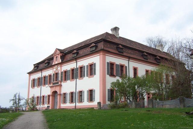
Großgründlach Castle

To be privately owned

Gründlach Castle rises directly west of the church on a slight hill above the lowlands of the river of the same name. We first learn of the existence of a castle in 1326, when Margarethe von Gründlach, sole heiress of the family property after the death of the last male namesake around 1314/15, and her husband Gottfried von Hohenlohe-Brauneck sold Gründlach with "castle, market, court and church patronage" and other possessions [cf. Malmsbach] to Burgrave Friedrich IV of Nuremberg.

The castle is largely preserved in the cellars and outer walls of the baroque-style castle of the Barons von Haller. Its walls, over three meters thick, were – still visible at the base and in the cellars – clad with precisely cut bossed ashlar blocks, which were used almost exclusively for imperial buildings in our region in the decades around 1200.

Gründlach was the ancestral seat of the imperial ministeriales of the same name, who have been documented in the king's vicinity since 1140. At the latest since their participation in the Meranian War of Succession (after 1248) on the side of the Bishop of Bamberg, their possessions and influence had visibly increased. This is evidenced by marriages with the noble free lords of Schlüsselberg and Ahorn, the foundation of the Frauenaurach monastery (before 1271) and finally the election of Leupold von Gründlach as Bishop of Bamberg (1296).

In Gründlach, they had extended the old village center around the regularly laid out northern main street (probably the market mentioned in 1326), which leads exactly to the church tower. The church was probably built in the 13th century in place of a castle chapel, whose apse foundations were uncovered in the nave of the church in 1987; the rising masonry of the north side is still preserved in the northern nave wall of the present church.

In 1326, the castle appears as the private property of the Gründlach family, over which they and their successors freely disposed. In 1343, Burgraves Johann and Albrecht sold the inherited "fortress" to Kunigunde, widow of Count Otto VII of Orlamünde, who founded the Cistercian convent Himmelthron in the same year. The castle and its appurtenances (including the surrounding orchard and the farmstead located above the main street), valued at 5,000 pounds Heller, initially served as an investment for the monastery, the administration of which the Countess entrusted to Konrad Groß, the founder of the Nuremberg Heilig-Geist-Spital.

However, disputes arose, leading to the convent's relocation to Großgründlach in 1348. The parish church was converted into a monastery church and extended to the castle for this purpose, which in turn was adapted into a monastery. No other details are known about the nature and extent of the construction work. The year 1464 on the central column of the large south cellar probably indicates a later repair.

In the course of the Reformation, the convent dissolved itself in 1525. The imperial city established its own office for the associated 36 properties in Großgründlach and an estate in Reutles, whose administrator resided in the monastery – i.e., the former castle. From the probate inventory of the administrator Wolf Löffelholz, who died in 1545, we learn at least of the rooms present at that time: a large hall, a spacious living room and the abbess's room, as well as seven sleeping chambers for children or guests, servants and maids. In addition, a kitchen, cellar, the old refectory (used as a pantry), a small bathhouse, and a rabbit chamber for storing hunting equipment are mentioned, and finally the carpenter's room, the rider's room, and the gatekeeper's room.

A few years later, the Second Margrave War hit Gründlach on May 23, 1552, like hardly any other place: "Gründlach, also a women's monastery, that was miserably burned down together with the church and the entire village." The damage to the (monastery) castle was estimated at 6,000 guilders, and to the church at 3,000 guilders.

In 1572, the Nuremberg patrician Philipp Geuder bought the buildings, which had only been provisionally repaired by the council after 1552, along with the associated property for 12,000 guilders, and had the castle rebuilt within the existing enclosing walls at considerable expense. After his early death in 1581, the property initially fell to his widow Katharina, née Welser, who had provided the capital needed for the purchase. However, the castle had only been partially restored provisionally and was still conceived as a defensive structure. For during an inspection around 1585/90, it was found that the castle tower built onto the manor house, "underneath which was the prison" (the old keep), only had a makeshift roof. Therefore, only a single cannon could be placed there. Mrs. Geuder intended to "cover the tower with a complete roof structure so that she could have cannons on all four sides." Otherwise, it would probably have to be half demolished and rebuilt. The first more precise views date from this period in the Pfinzingatlas (1590), in the so-called Cnopf's Sketchbook (around 1612/14) and in an anonymous pen drawing.

In 1616, the Pfinzing family inherited the castle and the manorial lordship, which led to decades of lawsuits with the Welser family, who also claimed Gründlach. In this context, several building damages were noted during an inspection in 1625. The gate was "rotten at the hinges," the floorboards at the entrance of the house in the threshing floor were "quite worn out," and the wooden "gang seulen" in the courtyard (which perhaps belonged to an open gallery?) were also damaged. Karl Pfinzing therefore intended to cut off the columns and place them on stone plinths.

Also "in the cow and pig stalls below in the castle courtyard" there was "some rotten wood that needed to be replaced," which Pfinzing promised to fix, as well as the half-timbered barn in the farmyard, which was only boarded up with partly dilapidated planks; he wanted to "have it bricked out between the beams with rubble."

In 1634, the castle, village, and church were destroyed by Bavarian troops. The manor house was set on fire, and since "a passage went from there up into the church," the fire also "ran into the church." Several large-format pen drawings by Johann Andreas Graff show the state of the castle ruins and the rebuilt church in 1685. Together with the aforementioned illustrations before 1634, they allow a reconstruction of the old building condition.

The outer walls formed an approximate square with sides almost 30 meters long. At the southeast corner stood the old keep, in front of which a gatehouse was built; next to it, the entrance led into the largely windowless ground floor and the inner courtyard. On the upper floor, the narrow window arrangement on the western south side was particularly striking, probably indicating the location of the hall. Turrets on the attic floor corresponded to the keep at the three other corners; a dormer also rose in the middle of the south front. On the east side, the former nunnery church, also two-story and under one roof with the nave of the church, was attached. At ground level, a door (now a window), only discovered in 2006, led from there into three small vaulted rooms, which, apart from the cellars, are the only ones to have survived the destruction of 1634. The elaborate Renaissance gate, which led from the Großgründlach main street into the garden, also remained standing until around 1811.

After a planned restoration of the castle in 1641 proved unfeasible, it remained a ruin for a total of 50 years. Only in 1685 did Karl Sebastian Pfinzing begin with the reconstruction (he obtained the timber from his own forests), but he died in the same year. At the end of 1698, the Waldamt Sebaldi spoke of the "mostly completed castle construction" and demanded the submission of plans for calculating future timber requirements. The following year, the master builder Johann Trost drew the ground plan of the old foundations as well as the ground, upper, and attic floors. In February 1700, the Waldamt confirmed the receipt of the plans "for the newly rebuilt Pfinzing Castle," and in 1705, Pastor Tobias Münch swore his oath of allegiance "in the newly built castle in Gründlach."

Using the preserved outer walls, a baroque two-story, four-winged building enclosing a regular courtyard was erected in place of the old castle (the open arcades on its south side were walled up only in 1924). The entrance was moved to the center, and the facades received uniformly arranged windows. The originally planned expansion of the mansard roof, enlivened by dormers, was abandoned. The keep was demolished, as was the former monastery church, which had formed the link between the castle and the parish church.

The interior work continued for a longer period. Modifying the plans of 1699, the remarkable, richly stuccoed theater hall with the alliance coats of arms of Christoph Carl Pfinzing (1680–1739) and his wife Helena Catharina Tucher, who died in 1720, was furnished around 1720. A year later, Pfinzing had a medal minted commemorating the redesign of the church (1719) and the completion of the castle. In contrast, the Latin inscription above the entrance states that the construction work was completed only in 1723. In the following decades, several rooms also received magnificent stucco ceilings, some of which were attributed to Donato Polli, which is unlikely to be correct.

It cannot be determined whether Johann Trost, who died in 1700 and had drawn the plans in 1699, also supervised the construction, as the building records have long been lost. Kreß stated in 1889 that the facade was executed "according to the somewhat clumsy proposals of the mason Jakob Ingwer from Danzig." Apparently, he still had a corresponding drawing, which has since disappeared. The involvement of Johann Ulrich Mösel, who worked for Pfinzing's brother-in-law Christoph Wilhelm Tucher [cf. Behringersdorf IV] around the same time and also for Pfinzing himself at the Großgründlach church in 1719, would also be conceivable.

After the Gründlach line of the Pfinzing family died out, the castle and manorial lordship passed to the Henfenfeld line in 1739 and, after their extinction in 1764/66, to the Haller family. They also continued the beautification of the castle and garden. Above all, in 1769, an avenue was created, establishing a visual axis from the entrance gate on the main street through the baroque garden in front of the castle to the west, leading to a chain of ponds between the two arms of the Gründlach, which had been gradually abandoned since 1794. The avenue of Lombardy poplars newly planted around this time had to be replaced several times later, most recently in the autumn of 2004 with winter lindens. Since 1766, the castle belonged to the twin brothers Johann Georg and Johann Sigmund Haller von Hallerstein. For the latter, who as Reichsschultheiß had guided the fortunes of Nuremberg from 1794 to 1804 until shortly before its incorporation into the Kingdom of Bavaria, a neoclassical monument was erected in 1805 on an artificial hill in the so-called Herrenwiese.

Since 1873, the castle has belonged to the Sigmund Frhr. von Haller Family Foundation. A bomb attack in 1943 caused significant damage to the roof, windows, doors, and stucco ceilings, which were repaired starting in 1947. The costly restoration and renovation measures of recent decades have led to Großgründlach being one of the best-preserved castles and manor houses in the Nuremberg area today.

Take Mobile History with you

You are reading this text for free. Premium adds what matters on the road: descriptions read aloud, sites found through your camera, whole regions taken offline.

  • Every description, including the ~17,700 Premium sites
  • Audio guide: have descriptions read to you on location
  • AR finder: see sites through your camera, with distance and bearing
  • Unlimited saved sites

14 days free, then from €2.99 a month. Cancel anytime.

Source: Wikipedia · Licence: CC BY-SA 4.0 · Image: http://de.wikipedia.org/wiki/Datei:Grossgruendlach_schloss_ansicht_v_so.jpg

This description draws on the facts documented in the linked Wikipedia article; Wikipedia content is licensed under CC BY-SA 4.0. Wording and editing: Mobile History.

Location: 49.5301, 11.0107