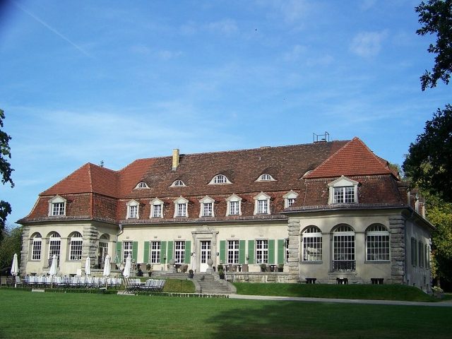
The Castle can be visited
Kartzow Castle
The village of Kartzow is located on the edge of the Döberitz Heath, approximately 12 kilometers northwest of Potsdam. The village area is bordered to the west by a lowland channel, the Großer Graben, to the east by the Fahrland Chaussee, and to the north by the Dorfstraße which flows into it. The southern boundary is formed by the former manor and its associated park, which is now operated under the name Schloss Kartzow.
The first written mention as the parish village of Cartzow dates back to 1357. Earlier settlement is indicated by Bronze Age urn fields on the northwestern edge of the village and early Bronze Age settlement and grave finds within the village.
The small linear village was probably originally built with a single row of houses. It lies on the medieval trade route running from Saarmund to Nauen, which was likely decisive for the development of the village. In Emperor Charles IV's Landbuch of 1375, a priest, two nobles, and 14 Kossäten farms are mentioned, of which five farmsteads were already deserted. No peasants are mentioned. Furthermore, the village had an inn.
After 1412, the (von) Spil family owned shares in Kartzow. Before 1412 until 1729, the Hünickes held sovereignty and seven free hides or the entire village with high and low justice, street justice, patrimonial justice, and a heath near the Wolfsberg.
In the castle register of 1450, the Hünickes are listed as the sole owners of the village and a farm with seven free hides. Only in 1624 are ten Hufner (full farmers) listed. The Hünickes owned property in Paaren and Satzkorn, among other places. In 1708, six three-hide farmers, including the Schulze, four Kossäten, a blacksmith, and a village shepherd were recorded. The last owner from the von Hünicke family, Cuno von Hünicke, sold the manor in 1729 to Ludwig von Fronhofer.
Until after 1859, the manor owners changed frequently. In 1840, 20 residential houses in the village and the manor were recorded, which at that time was owned by Johann Carl Sietlow, who brought it to economic prosperity.
Until the mid-19th century, half-timbered construction with thatched roofs dominated the rural appearance. This changed after the "Great Fire" of 1873, which claimed the church and most of the half-timbered buildings. The newly erected buildings were predominantly constructed in brick.
The church was also rebuilt in 1879/80 in the Neo-Gothic style, as a hall church with a polygonal choir and a recessed west tower. An inscription on one of the three church bells points to the Berlin architect Theodor Prüfer. The atonement cross remained the only medieval testimony in the churchyard.
At the beginning of the 20th century, the Berlin spirits manufacturer Arthur Gilka took over the manor; the existing distillery and the good soil quality of the arable land were probably decisive.
He had the manor converted into a representative, three-winged manor house in Baroque style by the Berlin architect Eugen Schmohl between 1912 and 1914. After Gilka's death in 1937, the manor was sold by his widow to Major Krossa. He sold it to the Wehrmacht in 1941, as a further significant expansion of the Döberitz military training area was planned to extend to Kartzow. In 1940, Schloss Kartzow served for exterior shots of the National Socialist German feature film "Kopf hoch, Johannes!" by Viktor de Kowa.
After the end of the Second World War, approximately 50 hectares of the former Döberitz manor district were expropriated and assigned to the Kartzow municipality in 1945. The manor house served as accommodation for displaced persons from 1945-49 and was converted into a children's convalescent home in 1949. From 1974 to 1991, the manor house served as a children's home, then until 1996 as a sanatorium for children with kidney disease. From 1998 to 2006, the manor house stood empty and was only sold in December 2006. Since then, it has been extensively reconstructed. Since 2008, a branch of the Potsdam registry office has been located there, and one can already indulge in culinary delights on the castle terrace.
In 1953, an agricultural production cooperative was established in the village, which joined the Horticultural Production Cooperative in Neu Fahrland as an operating unit in 1965. Apple orchards were then created on the fields around Kartzow. In the village itself, a plant protection station and some facilities for producing frozen vegetables were also established. The fall of the Berlin Wall then brought an end to the agricultural facilities.
Kartzow, which until 1952 belonged to the district of Osthavelland as an independent rural municipality and from 1952 to the district of Potsdam, was incorporated as a district into Fahrland on March 14, 1974. Since October 26, 2003, Kartzow has been a district of Potsdam.
Take Mobile History with you
You are reading this text for free. Premium adds what matters on the road: descriptions read aloud, sites found through your camera, whole regions taken offline.
- Every description, including the ~17,700 Premium sites
- Audio guide: have descriptions read to you on location
- AR finder: see sites through your camera, with distance and bearing
- Unlimited saved sites
14 days free, then from €2.99 a month. Cancel anytime.
Source: Wikipedia · Licence: CC BY-SA 4.0 · Image: http://de.wikipedia.org/wiki/Datei:Schloss_Kartzow.JPG
This description draws on the facts documented in the linked Wikipedia article; Wikipedia content is licensed under CC BY-SA 4.0. Wording and editing: Mobile History.
Location: 52.4913, 12.9800