To be privately owned
Niederraunau Castle
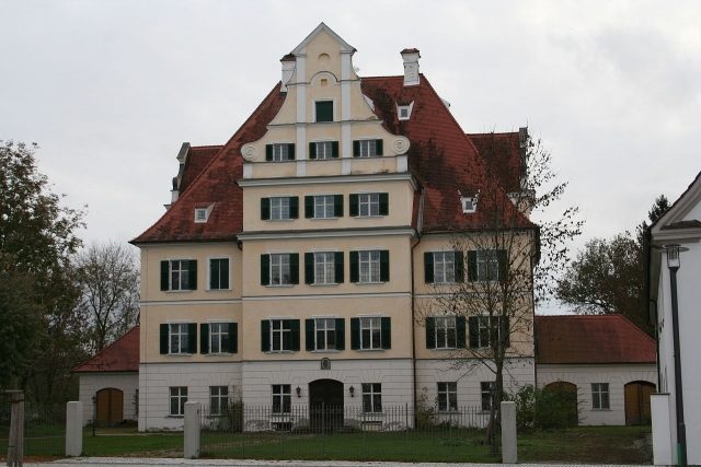
Niederraunau Castle is a three-story hip-roofed building constructed in 1733 in Niederraunau, a district of Krumbach, in the Swabian district of Günzburg. The castle and the adjacent Catholic parish church of St. Maria and All Saints, built not far from the Kammel river, characterize the townscape of the village.
The history of the castle dates back further than that of the current building. From old maps, it is known that the predecessor building was a moated castle. The history of the castle and the lordship of Niederraunau is closely linked to the noble family of Freyberg, who were the local lords of Niederraunau for almost 400 years, from 1477 to 1850. Around 1500, the neighboring villages of Hürben and Aletshausen also belonged to their dominion. In 1525, the castle was plundered during the Peasants' Revolt. 32 years later, in 1557, the lordship passed to the main line of Freyberg-Eisenberg. From 1586, members of this line were allowed to call themselves Barons of Freyberg. After the destruction of their ancestral castle near Pfronten during the Thirty Years' War in 1646, Niederraunau became the main residence of the nobles, who determined the history of Niederraunau until 1846. In that year, they renounced jurisdiction, and four years later, they sold the property including the castle to the Barons of Ponickau. After the latter also resold the castle, the owners changed frequently.
The current castle was built under Joseph Franz Eustach von Freyberg. Simpert Kraemer is often named as the master builder, but this cannot be definitively proven. The castle acquired its current appearance in 1844 through the demolition of the right wing and the corridor that connected the castle to the church.
The outbuilding, standing freely perpendicular to the north of the castle, was erected in 1694, according to the date on a coat of arms on the building. Nothing remains of the former castle garden since a redesign in 1967.
Architectural Description+
The three-story hip-roofed building, measuring approximately 24 m by 27 m in plan, is characterized by the risalits on the east and west sides and the half-height gables on the south and north sides. Inside, the spacious, very bright staircase, illuminated by the windows, is noteworthy. The rooms on the ground floor have cross-rib vaults, while those on the upper floors have flat ceilings over profiled cornices. The historical furnishings, with the exception of a few items, such as some two-panel doors, have been lost over time. The cellar vaults of the building are likely to date from the predecessor building.
Take Mobile History with you
You are reading this text for free. Premium adds what matters on the road: descriptions read aloud, sites found through your camera, whole regions taken offline.
- Every description, including the ~17,700 Premium sites
- Audio guide: have descriptions read to you on location
- AR finder: see sites through your camera, with distance and bearing
- Unlimited saved sites
14 days free, then from €2.99 a month. Cancel anytime.
Source: Wikipedia · Licence: CC BY-SA 4.0
This description draws on the facts documented in the linked Wikipedia article; Wikipedia content is licensed under CC BY-SA 4.0. Wording and editing: Mobile History.
Location: 48.2230, 10.3779