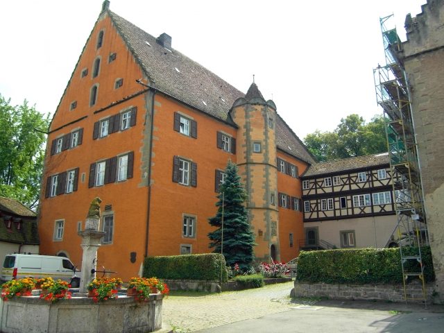
CastleObersontheim

Obersontheim Castle

Obersontheim Castle

Nursing home

Obersontheim Castle is the former residence of a branch of the Imperial Counts of the Schenken von Limpurg family. It is located in the eponymous main town of the municipality of Obersontheim in the district of Schwäbisch Hall in northeastern Baden-Württemberg.

The castle is situated at the intersection of the roads between Schwäbisch Hall and Ellwangen, and Gaildorf and Crailsheim, about 10 meters high above the old village center of Obersontheim in the valley, on the northwestern foot of a flat hill that descends from the high terrace to the floodplains of the Bühler river, which flows less than 100 meters from the castle. From the north tower, the main road of the village in the valley leads southeast-upstream towards Ellwangen and Crailsheim, northwest-downstream towards Schwäbisch Hall, southwest towards Gaildorf, a steep road climbs an initially high retaining wall-bordered stream valley incision towards the castle. East of the castle, at some distance, are the village church and town hall, which were built at approximately the same time. To the south, a large garden belonging to the castle grounds extends up the remaining slope to the hill.

The castle was built in the 16th century by Schenk Erasmus, who sold Limpurg Castle, which gave the family its name, to the nearby Imperial City of Schwäbisch Hall in 1541 after a long dispute, and created a new residence in Obersontheim. The keystone above the door to the main wing bears the year 1543, the double coat of arms of Schenk and his wife above it shows the year 1544, and the gate tower coat of arms stone shows the year 1562. After the Schenken died out in the male line in 1713, the castle had various owners until the Samariterstiftung opened a nursing home in the buildings in 1904.

The nursing home still exists today (2008). However, the foundation intends to vacate the premises in the foreseeable future. In recent years, continuous renovation work has taken place with a view to repurposing.

Architectural Description+

The castle buildings roughly form a horseshoe open to the northeast. The oldest wing ("Erasmusbau") is also the largest, located in the southeast facing northeast, about 32 meters long, about 15 meters wide, and has three stories and three attics under a gabled roof. The lowest story only begins at a height of two to three meters above ground, below which is a gate to a wide staircase leading down into a continuous vaulted cellar. Centrally positioned against the inner courtyard of this wing is an octagonal stair tower with a spiral staircase, through which one enters the wing.

Northwest parallel to this lies the younger wing ("Friedrichsbau"), according to its coat of arms tablet brought "under roof" in 159? (last digit illegible), equally long, but otherwise of consistently reduced dimensions. It is only about 13 meters wide, its story height, eaves height, and its octagonal spiral stair tower, also positioned against the inner courtyard, are noticeably smaller than those of the south wing. Towards the inner courtyard, however, its gabled roof has a lucarne, and on the outside, two large dormer windows and a row of smaller dormer windows.

In the southwest, these two main buildings are connected by a narrow transverse wing about 18 meters long. Northeast of them and the inner courtyard thus enclosed on three sides is a wider courtyard of approximately the same depth, which is bounded in the east-southeast by a flat and narrow building complex, through which, identifiable by the loopholes on the outside, a battlement ran. In its center stands a small gate tower, in front of which a stone bridge spans the moat, forming the main access to the castle from the village center. At the top of the gate tower, the wooden rollers of an old drawbridge are still visible today. The northwestern opposite side of the outer courtyard is bounded by a visibly newer wing, under which, adjacent to the adjoining north wing, an archless, rectangular passage leads. In the middle of the outer courtyard stands an 18th-century fountain made of light tufa.

The castle has round towers, half projecting from the outer fronts of the castle quadrangle, at three of the four corners. The hill-side west tower rises highest, it has a diameter of about 9 meters and bears a conical roof. The northern and eastern corner towers are founded deeper at valley level, their roofs have the shape of a hyperboloid of revolution. The eastern one, facing the inner village, does not reach the eaves height of the south wing at its peak. There is no tower in the south corner, although the adjoining terrain rises most steeply here, but a zwinger is still located in front of the main wing on the southeast side.

In the northeast, a retaining wall drops steeply to the village and valley in front of the outer courtyard. In the southeast and southwest, a moat up to about 10 meters deep surrounds the complex, which is at least heavily filled where the aforementioned access bridge crosses it today. On the northwest side, there is no moat in front of the building facade today.

Window reveals, door frames, and coat of arms stones are made of light green sandstone. Isolated unplastered areas on the building walls and all three visible stone towers show the same building material. On the west tower, the old plaster was only recently removed during renovation work; the other two were unplastered before. The more modern extension northwest of the outer courtyard has limestone reveals. Two downspouts of the main wing end in dragon-head gargoyles.

The moat in the southwest towards the hill is now spanned by a stone arch bridge, which allows residents easy access to the garden. Next to it, a freight elevator tower stands in the moat at the rear of the transverse wing.

Take Mobile History with you

You are reading this text for free. Premium adds what matters on the road: descriptions read aloud, sites found through your camera, whole regions taken offline.

  • Every description, including the ~17,700 Premium sites
  • Audio guide: have descriptions read to you on location
  • AR finder: see sites through your camera, with distance and bearing
  • Unlimited saved sites

14 days free, then from €2.99 a month. Cancel anytime.

Source: Wikipedia · Licence: CC BY-SA 4.0

This description draws on the facts documented in the linked Wikipedia article; Wikipedia content is licensed under CC BY-SA 4.0. Wording and editing: Mobile History.

Location: 49.0572, 9.8969