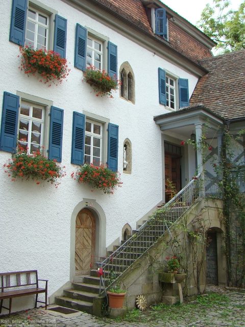
CastleOedheim

Oedheim Castle

Oedheim Castle

To be privately owned

Oedheim Castle (often also called Bautzenschloss) is a castle on the banks of the Kocher river in Oedheim, Baden-Württemberg. It can be traced back to a Staufer-era castle complex and was the ancestral seat of the Capler von Oedheim family, known as Bautz. The castle is now privately owned and not publicly accessible.

Lords of Weinsberg

The complex, first mentioned in a document in 1202, was built under the Lords of Weinsberg probably in the last third of the 12th century, at the latest in the 13th century, in any case after the victory of the Staufer over the Welfs in the Battle of Weinsberg in 1140. This dating is also supported by the typical construction as a shield wall castle.

In Oedheim, the Öhringen–Neuenstadt–Gundelsheim road crossed the Kocher by means of a ferry. The road was of strategic importance to the Weinsberg family in securing their rule north of the Kocher and Jagst rivers. The castle's task was to secure the ferry, which until 1765 was located as an extension of today's Fahrgasse, and it was probably also the seat of a vogtei (bailiwick). The Staufer-era defensive complex included a fortified residential tower (today's southwest building), an inner courtyard, a castle wall, and a neck ditch.

It is unclear when the Capler family, whose representatives, as vassals of the Lords of Weinsberg, probably came from the Gmünd area and who are documented in Oedheim since 1235, were enfeoffed with the castle.

Palatinate and Württemberg until 1805

In 1335, the Lords of Weinsberg sold the Lordship of Scheuerberg, including Oedheim, to the Archbishopric of Mainz, but initially remained in possession of the castle. In 1449, the castle fell to the Electoral Palatinate, and in 1484 to Württemberg. Mainz pledged its office of Scheuerberg with Oedheim to the Lords of Sickingen in 1467 and exchanged it with the Teutonic Order in 1483. Thus, for over 400 years, the castle was a Württemberg exclave within the territory of the Teutonic Order.

The first Capler documented as lord of the castle in Oedheim was Ulrich Capler von Oedheim, called Bautz (* around 1360; † around 1437). In 1408, he acquired the later castle garden from his brother-in-law, Sefried von Gosheim. The difficult territorial conditions regularly led to disputes between the Caplers and the Teutonic Order, for example regarding hunting or water rights or border demarcation. At the beginning of the 16th century, the relationship improved, and as a result, Ullrich Capler was able to build the widow's house on the community's territory. In 1550, the Caplers expanded the castle with a wine press and tried to oblige the tenants of the Capler vineyards (which were also located on Teutonic Order territory) to deliver their grapes there, which met with protests from the Teutonic Order.

During the German Peasants' War, the castle remained undamaged, but the troops of Margrave Albrecht II Alcibiades of Brandenburg-Kulmbach plundered it during the Second Margrave War in May or June 1554 and partially destroyed it. Around 1560, reconstruction followed, during which the building lost its character as a castle and the neck ditch was filled with rubble. After the renovation, 17 rooms and chambers, two stables, as well as a kitchen, cellar, and bathhouse were available.

Around 1700, the Caplers first took in protected Jews in their castle. Remains of the Jewish houses can still be found in the castle forecourt today. In 1864, 76 Jews lived in the castle. In 1846, the Jewish community acquired the building Fahrgasse 14 – located outside Bautzenschloss, but still on Capler territory – and established the new Oedheim synagogue there. It was replaced by a new building in 1864, closed in 1939, and converted into a two-family house in 1966.

After 1805

In the course of mediatization, Oedheim came to Württemberg in 1806, meaning that the town and castle once again belonged to the same sovereign.

At the end of the Second World War, the castle suffered minor damage. As part of the Lastenausgleich (equalization of burdens), the Caplers had to cede parts of the eastern castle garden for social housing.

With the death of the last representative of the Capler von Oedheim family, Dietrich Capler von Oedheim called Bautz, in 1967, the castle became orphaned. Attempts by the heirs, the von Gemmingen and Strauss families, to make the property available to a non-profit organization failed due to high renovation costs. It stood empty until the municipality of Oedheim acquired the castle with the surrounding property for 1.25 million DM in 1986. The municipality divided the area and built the St. Elisabeth kindergarten on the remaining eastern part of the castle garden in 1991 and the Kochana festival hall west of Degmarner Strasse on the site of the former farm buildings in 1996–1997. In 1995, a private investor was found who acquired the castle for 450,000 DM and renovated it.

The castle now serves as a residential and office building for its owners. It is not publicly accessible, but individual halls can be rented for events.

Description+

Oedheim Castle is located on the steep slope of the Kocher river, parallel to the river, which flows here from northeast to southwest. The Fahrgasse, as access to the former ferry, meets the river at a right angle to the south as a hollow way. The three sides not facing the Kocher were protected by a moat about 2.5 m deep until the reconstruction around 1560. The 2.7 m thick shield wall protected the main attack side to the northeast and is partially preserved. The well-preserved wall facing the Kocher has a thickness of 1.2 m, and the curtain wall to the southeast and southwest has a thickness of 1.75 m. In the late Middle Ages, probably between 1460 and 1510, the Caplers reinforced the castle towards the village with a zwinger (demolished in the 19th century) and the flanking shell tower. The arch of the entrance gate shows the coats of arms of the Capler and Gemmingen families with the year 1692.

In the southwest is the three-story main building, opposite which to the northeast is a two-story building. On the side facing the river, an intermediate section connects the two. Towards the village, the enclosing wall and the tower complete the complex.

The massive, square main building in the southwest still bears witness to the Staufer-era castle; it formerly served as a fortified residential tower. Until the 17th century, it probably had another floor in half-timbered construction. In the 16th century, various smaller extensions were made, such as the addition of a bay window. In the 19th century, probably between 1860 and 1875, further changes occurred: the windows were enlarged, the mansard roof was newly created, and the interior rooms were redivided and redesigned. The last changes to the southwest building took place around the first decade of the 20th century in the staircase and on the 2nd floor.

The northeast building was built in its current form around 1690 on an already existing cellar, whose entrance arch shows the year 1533 and the coats of arms of the Capler and Bibelheim families. The building has massive walls with double windows and half-timbered walls to the southwest. The ground floor served as a wine press. The intermediate building, whose construction period is not clear, was probably redesigned between 1860 and 1875: windows, doors, and the gallery date from this period.

Take Mobile History with you

You are reading this text for free. Premium adds what matters on the road: descriptions read aloud, sites found through your camera, whole regions taken offline.

  • Every description, including the ~17,700 Premium sites
  • Audio guide: have descriptions read to you on location
  • AR finder: see sites through your camera, with distance and bearing
  • Unlimited saved sites

14 days free, then from €2.99 a month. Cancel anytime.

Source: Wikipedia · Licence: CC BY-SA 4.0 · Image: https://commons.wikimedia.org/wiki/File:Schloss-oedheim-2008-001.jpg

This description draws on the facts documented in the linked Wikipedia article; Wikipedia content is licensed under CC BY-SA 4.0. Wording and editing: Mobile History.

Location: 49.2413, 9.2567