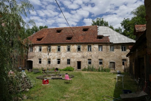
CastleOllendorf

Ollendorf Castle

Ollendorf Castle

To be privately owned

The Ollendorf Water Castle is a former water castle in Ollendorf (Thuringia). The Ollendorf Water Castle is located on the southwestern edge of the municipality on Erfurter Straße (L 1055), which in the Middle Ages was a section of the Via regia and had supra-regional importance as a military and trade route.

The water castle was probably built by the Counts of Gleichen. In the 14th century, the Counts of Gleichen counted parts of Ollendorf as well as the adjacent lordship of Vieselbach among their possessions. In 1506, the Counts sold their Ollendorf property, including the water castle and the fish farm in the moat, to the city of Erfurt. The city appointed an administrator who was to ensure the agricultural exploitation of the estate and the security of the fortifications. Although the water castle increasingly lost military significance in the 15th and 16th centuries due to the development of artillery, it was occupied by city guards during the Thirty Years' War. Its commander was in charge of the militia system of the surrounding villages at that time.

In 1609, a fire occurred, which made it necessary to rebuild the farm buildings and several stables. But even otherwise, the water castle was continuously subjected to repairs. This was offset by the income from fish farming. For this, records of the purchase of frogs, mostly from the frog merchant of Zimmern, are available in the city archive until 1664. On average, 400 shocks of frogs had to be fed per year. Snails and spent grain were also used as feed.

In the middle of the 16th century, the Erfurt Council leased the castle and the free estate for 150 guilders annually. In 1624, the administration of the bailiwicks of Zimmern and Udestedt was moved to the fortified noble court of Ollendorf, the water castle. In 1664, the castle and free estate, along with all of Erfurt's possessions, passed to Mainz. In 1692, the farmstead belonging to the castle and the castle itself burned down to the ground. In 1694, it was rebuilt for agricultural purposes, and the manor house was erected in the style of simple rural Baroque.

On November 22, 1813, Napoleon intended to spend the night at Ollendorf Water Castle on his retreat from the Battle of Leipzig. However, as enemy cavalry was reported near the village, he left the village towards Erfurt around midnight. In 1863, the estate complex was rebuilt and expanded. The Electoral Chamber Estate changed owners several times over the years. In 1945, the owners were expropriated and expelled by the communists.

During the GDR era, the water castle served the LPG "Einheit" as a farmyard for decades. Since that time, the complex has been severely decaying. Since the 1970s, the buildings have been vacant.

Construction Description+

The arrangement of the buildings forms a castle courtyard in the shape of an irregular quadrangle. Of the old fortifications, only the foundation of an old corner tower northeast of the main house can be seen today. Until the 19th century, the only access was via the drawbridge, which was then replaced by a fortified bridge with a stone vault and archway. The manor house, which is still present today, was rebuilt in 1694 in the rural Baroque style. From this time on, the entire property served exclusively for agriculture. The shingles for roof repairs were mostly sourced from Tambach, and the shingle nails came from Ollendorf. The drawbridge often had to be repaired, and the moat, which covers 1,800 m², was regularly excavated.

Current Situation+

Since 1997, the complex has been managed by the Arbeitskreis Denkmalpflege e. V. (Working Group for Monument Preservation). In close cooperation with the Verein Offene Häuser e.V. (Open Houses Association), a pilgrim and hiking hostel is to be opened in the reconstructed rooms, and the entire complex is also to become a cultural center for the local population.

As a "compensatory measure 500" for the construction of the BAB 71 (according to an information board), the outdoor areas of the "castle" were renaturalized, the moats and the adjacent upper pond were desilted, the embankment was renewed, and trees and hedges were planted in the late 1990s.

Take Mobile History with you

You are reading this text for free. Premium adds what matters on the road: descriptions read aloud, sites found through your camera, whole regions taken offline.

  • Every description, including the ~17,700 Premium sites
  • Audio guide: have descriptions read to you on location
  • AR finder: see sites through your camera, with distance and bearing
  • Unlimited saved sites

14 days free, then from €2.99 a month. Cancel anytime.

Source: Wikipedia · Licence: CC BY-SA 4.0 · Image: Mobile Geschichte

This description draws on the facts documented in the linked Wikipedia article; Wikipedia content is licensed under CC BY-SA 4.0. Wording and editing: Mobile History.

Location: 51.0384, 11.1898