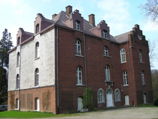
CastleAlsdorf - Ofden

Ottenfeld Castle

Ottenfeld Castle

To be privately owned

Ottenfeld Castle, also known as Ottenfeld Estate and Ottenfelder Hof, is a manor house with an associated estate in the Duffesheide district of Alsdorf. The building complex is located on Federal Highway 57 from Würselen to Alsdorf in the lowlands of the Broicher Bach and is one of the oldest farms in the municipality of Alsdorf. It is privately owned and cannot be visited.

Ottenfeld Castle is accessible via an approximately 190-meter long avenue that leads past a small Marian chapel. The complex is divided into a three-winged farm building with a gatehouse and a representative manor house.

The east wing of the farm building consists of several brick structures, the southernmost of which has two stepped gables. The most striking building of the wing is the two-story gate tower, which rises on a rectangular floor plan and is topped by a hip roof. The cordon cornice is highlighted by a round arch frieze. The round-arched gate passage on the east-facing exterior is framed by light ashlar blocks of bluestone. In the center above the archway are two stone coats of arms under a crown.

The manor house, located west of the farm building, is a three-story brick building from the last quarter of the 19th century. On a rectangular floor plan, two residential floors rise above a high basement, clad with slate shingles on the south and west sides. The house serves residential purposes and features large round-arched windows on all sides. The entrance portal in the basement – like the two flanking windows – has a frame of light ashlar. On the north side of the building, two very short, tower-like wings adjoin, which have a stepped gable with a round arch frieze on their front sides. These stepped gables are repeated as a decorative element on the dormers of the building's high, hipped roof. The eaves cornice is particularly emphasized by a brick frieze.

Not much is known about the history of the castle, as the castle archive and thus much information about the property's past were lost when American soldiers were quartered there in 1945.

The Ottenfelder Hof was first mentioned in a document as a Kurmutgut in 1420 in the so-called Weistum of the Lordship of Alsdorf. Around 1500, it was then owned by the Aachen Croisiers, who had it managed by a tenant. It is uncertain whether they acquired it by purchase or donation.

Around the 17th century, the property came into the possession of the baronial family von Blanckart, who also owned Alsdorf Castle. At that time, it was a typical Rhenish country estate, grouped as a closed four-winged complex around an inner courtyard.

In the early 19th century, a change of ownership occurred again for unclear reasons. A French plan drawing of the complex, made in June 1809, still shows a Baron von Blanckart as the owner, but already in 1846 the buildings were owned by Julius and Noel Harf, two Jews residing in Jülich. From them, Josef von Blanckart, brother of the owner of Alsdorf Castle, bought the estate back for his family in that year. In 1868, he also bought the Alsdorf oil mill (today Wintgens Hof) and the Alsdorf grain mill (today Linkens Mühle). Married to a Belgian Countess van Lindekerk, he later moved his residence to Belgium and left Ottenfeld to his son Karl. In 1878, the latter initiated a castle-like new building of the residential house, so that the estate was called Ottenfeld Castle from that time on.

Through inheritance, the property came to the children of the Belgian Countess Fritz von Borchgrave zu Lexhi, who are still the owners today.

Take Mobile History with you

You are reading this text for free. Premium adds what matters on the road: descriptions read aloud, sites found through your camera, whole regions taken offline.

  • Every description, including the ~17,700 Premium sites
  • Audio guide: have descriptions read to you on location
  • AR finder: see sites through your camera, with distance and bearing
  • Unlimited saved sites

14 days free, then from €2.99 a month. Cancel anytime.

Source: Wikipedia · Licence: CC BY-SA 4.0 · Image: http://www.wehrbauten.de/thread.php?threadid=845

This description draws on the facts documented in the linked Wikipedia article; Wikipedia content is licensed under CC BY-SA 4.0. Wording and editing: Mobile History.

Location: 50.8630, 6.1396