To be privately owned
Sandizell Castle

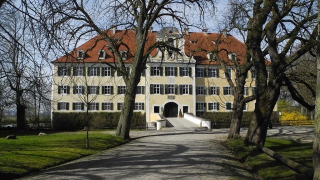
Sandizell moated castle is the ancestral home of the Counts of Sandizell, located about 7 km west of Schrobenhausen in Upper Bavaria.
Sandizell is first mentioned in 1007 as an economic farm of the Benedictine nuns from Neuburg an der Donau. In 1464, the fortification is referred to as a Hofmark of the Sandizells.
Sandizell Castle was expanded around 1580 into a three-wing complex in Renaissance style; this consisted of the east and west wings, as well as the south wing with a four-bay bridge leading to the entrance hall. Already in 1632, the Swedes burned down the complex during the Thirty Years' War, leaving only the east wing, which still stands today.
From 1749 to 1755, Sandizell Castle was rebuilt according to plans by the Neuburg master builder Johann Puchtler, and a two-story castle chapel was integrated into the central south wing. The gate tower was erected in 1763.
The castle park was laid out in the 1870s as an English landscape park. The park is not publicly accessible.
Hofmark Church+
In 1735, Johann Baptist Gunetzrhainer began the construction of the Hofmark Church, and in 1756, the tower followed by Leonhard Matthäus Giessl. The most significant work is the altar by Egid Quirin Asam.
The church houses the tombs of the Counts of and zu Sandizell and is connected to the castle park by a passage. The former Hofmark Church is now used as the parish church of St. Peter by the residents of Sandizell.
World History in Sandizell+
Sandizell Castle became historically significant when, in 1704, during the War of the Spanish Succession, the commanders Eugene of Savoy and Marlborough held a council of war there for the Battle of Höchstädt.
Current Use+
Today, the castle is owned half by Nikolaus Count of and zu Sandizell with his brother Tassilo, and Elisabeth with her son Horst Florian Jaeck. The castle is rented out for events and weddings.
Take Mobile History with you
You are reading this text for free. Premium adds what matters on the road: descriptions read aloud, sites found through your camera, whole regions taken offline.
- Every description, including the ~17,700 Premium sites
- Audio guide: have descriptions read to you on location
- AR finder: see sites through your camera, with distance and bearing
- Unlimited saved sites
14 days free, then from €2.99 a month. Cancel anytime.
Source: Wikipedia · Licence: CC BY-SA 4.0
This description draws on the facts documented in the linked Wikipedia article; Wikipedia content is licensed under CC BY-SA 4.0. Wording and editing: Mobile History.
Location: 48.5837, 11.1762