CastleFischenich

Weilerhof Castle (Fischenich)
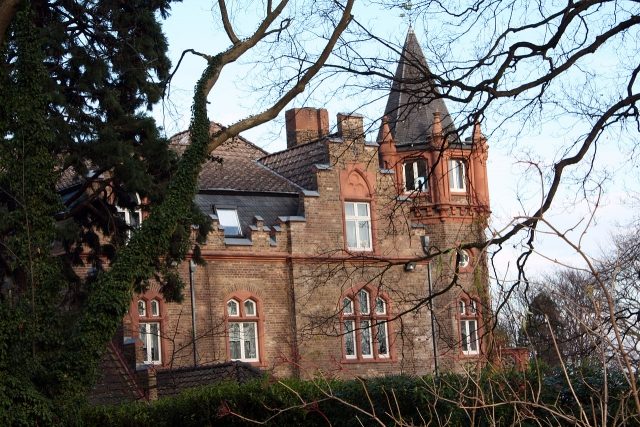
Weilerhof Castle (Fischenich)

To be privately owned

Right on the city limits to Brühl-Vochem in the south of the town lies the Weilerhof, which was exempt from taxes until the secularization and came to the mayoralty of Hürth with Fischenich in 1802.

According to documented findings, the farm's grounds are said to have been settled as early as Roman times. In addition to a number of smaller farmsteads (probably managed by sharecroppers), the manor house of the estate owner "Godescalcus de Wilre" is said to have stood here as early as the beginning of the 14th century.

At this time (from 1300), Cologne Carthusians gradually acquired large tracts of land and forest in the vicinity of the hamlet. The farm complex, which was also owned by the monks by 1407/08 at the latest, is reported to have been destroyed several times but always rebuilt. The last reported destruction was in May 1586 by Truchsessian troops, to whom Fischenich Castle had already fallen two years earlier. In 1587, the Weilerhof was rebuilt for 4298 Mark.

A wayside cross of the Weilerhof, about 5 meters high, dates from around 1730. The valuable cross stands under a group of old lime trees on the south side of the present farm complex. In harmonious articulation, the cross is divided into three areas:

The crossbeam with the corpus of the crucified fastened by iron nails, the middle part provided with an exposition niche and sumptuously finished with a stepped cornice, and the pedestal standing on a widened base and decorated with lateral volutes. This bears an inscription on its front, crowned by the insignia of the Carthusians.

Shortly before the secularization, the Carthusians cultivated 284 Morgen of arable land from there, and in addition to the forest belonging to the farm, another 12 Morgen of vegetable gardens.

The new lord of the manor also participated in the exploitation of lignite on the Vorgebirge slope. The small Weilergrube mine was consolidated in 1859 with the Wilhelmsglück field by the lord of the manor Friedrich Wilhelm Bendleb, but was already bought up in 1884 by Emil Sauer with other surrounding fields and merged into the Gewerkschaft Rheinland (later Ribbertwerke). In 1914, the fields were finally acquired and mined by the Gewerkschaft Hürtherberg.

The existing four-sided farm dates from 1911. A few years ago, the former brewing operation was resumed here. The Weilerhof today houses one of the smallest Kölsch breweries. It is operated by the Bischoff family, who are also involved in horse breeding. A beer garden is of recent date (Bischoff Kölsch).

The extensive property, surrounded by a wall and fences, is not publicly accessible. In 1896, the neo-Gothic manor house, built of field-fired bricks and standing on the slope of the Ville, attracted great attention at the time. Situated in a park with partly very old trees, it gives the impression of a small castle with its towers and battlements. Its access from Bonnstraße at the foot of the slope connects the stately house and the buildings of the Weilerhof through a densely wooded narrow avenue. As shortly after the end of the war in 1945, when the property was leased by the then owner to Cologne Caritas for several years (who used it as a nursing home for the elderly), the complex is still leased today.

The fish ponds on the Weilerbach were only created by the Carthusians. The valley of the largely natural stream is designated as a landscape protection area.

Take Mobile History with you

You are reading this text for free. Premium adds what matters on the road: descriptions read aloud, sites found through your camera, whole regions taken offline.

  • Every description, including the ~17,700 Premium sites
  • Audio guide: have descriptions read to you on location
  • AR finder: see sites through your camera, with distance and bearing
  • Unlimited saved sites

14 days free, then from €2.99 a month. Cancel anytime.

Source: Wikipedia · Licence: CC BY-SA 4.0

This description draws on the facts documented in the linked Wikipedia article; Wikipedia content is licensed under CC BY-SA 4.0. Wording and editing: Mobile History.

Location: 50.8499, 6.8948