CastleNeustadt an der Weinstraße - Mußbach

White House Castle
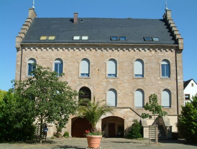
White House Castle

Vineyard
Apartments


The Weiße Haus (White House) is an extensive historic farmstead with remnants of a castle in the former wine-growing village of Mußbach, which was incorporated into Neustadt an der Weinstraße (Rhineland-Palatinate) as a district in 1969. Today, the listed complex is predominantly used for residential rentals, but is also still partly operated as a winery.

Geography+

Location

The Weiße Haus is located at Kurpfalzstraße 77 in the transitional area from Mußbach to the adjacent district of Gimmeldingen. Until after the Second World War, the building ensemble formed the northern boundary of an approximately ten-hectare area, which was then used for agriculture, especially for viticulture. Meanwhile, this area, which is bordered to the west and east by the streets Am Altenweg and Am Weißen Haus respectively, and to the south by the Mußbach stream, no longer belongs to the Weiße Haus; it is completely built up with single and two-family houses, behind which are associated gardens.

Surroundings

Opposite the Weiße Haus – already in the Gimmeldingen district – lies the historically noteworthy winery Estelmann, formerly Hick, which houses the wine tavern Loblocher Schlössel; 150 m to the east is the wine tavern Eselsburg, created by the expressionist painter and sculptor Fritz Wiedemann; 150 m to the west, on the outermost western edge of Mußbach, is the Carl-Theodor-Hof winery, built in 1709.

Buildings+

The building ensemble consists of a central paved inner courtyard, which is enclosed to the east by a massive slate-roofed main house, standing with its gable facing Kurpfalzstraße, and whose two stepped gables to the north and south are visible from afar. The main house with its round-arch windows rises two and a half stories high – with a floor height of four meters – above the cellar, which is spanned by a barrel vault. This is accessible from the courtyard almost at ground level via two segmental-arch gates, which lead inwards under the large, projecting double staircase.

To the south and southwest, the inner courtyard is flanked by a series of former farm buildings that previously served as barns and stables. To the west, it is bordered by a castle-like complex with a lean-to roof and a stair tower, behind which extends another, smaller inner courtyard, whose paved access runs along the farm buildings.

A massive rubble stone wall, about four meters high, runs around the entire west and north sides, and is crenellated on the north, along Kurpfalzstraße. Access to the large inner courtyard is also provided there via a now open portal system, which consists of a large round-arch gate with a small side gate – also with a round arch – and whose wall crown is about seven meters high. The smaller inner courtyard, in the middle of which lies a large bricked, now largely filled manure pit, also formerly had a gate opening towards Kurpfalzstraße, but this was bricked up in the first half of the 20th century.

Origin of the Name

The origin of the name is unclear. Exposed stones as well as plastered surfaces, especially of the main house, are relatively light, but were never white and do not appear so today. It would be equally speculative to conclude a possible former owner named Weiß or a former use as an orphanage.

Building History

The oldest part is the former castle, which also includes the courtyard wall and gate system, and dates back to the medieval knightly family of Rammingen. In 1598, the castle-like construction was completed by Erhardt von Rammingen. A poorly preserved canting coat of arms from 1600 on the north wall, whose escutcheon shows the ram in the upper right, testifies to him as the builder; the depiction of the animal alludes to the siege engine, also called a ram, from which the family derived its name. A baroque barn features Renaissance building elements dated 1608. Since Erhardt remained without a male heir, ownership passed to his son-in-law Carl von Pawel, who came from Braunschweig and had married Erhardt's daughter Anna von Rammingen around 1590. Pawel was a Palatine Electorate councilor and court master to the Elector Palatine.

Twice, in 1689 during the War of the Palatine Succession and in 1793 after the French Revolution, the castle was burned down by French troops; it was subsequently rebuilt each time. Some of the farm buildings date from the early 18th century. In the 19th century, battlements were added to the wall. The main house, built in 1890 by Ludwig Wolf as the client, with its large round-arch windows and the battlements on the gable walls, indicates its origin in the Gründerzeit (founding era).

Recent Times

In 1919, Adolf and Emilie Fischer acquired the property from Franz Pfaff, who was the owner during the First World War. They raised the stair tower of the castle by one story and installed a tower clock on its east side. The Fischer family operated the complex as a winery until after the Second World War. Then, the area to the south with the former vineyards was sold off piece by piece and developed with single-family houses. In 1955, the now widowed Emilie Fischer sold the older western part of the remaining building ensemble to the brothers Hans (1913–2006) and Hermann Keil (1918–1998), who, born and raised right next door, operated a trading business for bottles and winery supplies there for more than 30 years. This part of the property is still owned by the heirs of the Keil brothers. The descendants of Emilie Fischer sold the eastern part of the buildings in the 1970s to Hermann Müller from Gimmeldingen, who rented out the main house for residential purposes. Apart from renovation work, no further construction measures have taken place since the 1920s.

Take Mobile History with you

You are reading this text for free. Premium adds what matters on the road: descriptions read aloud, sites found through your camera, whole regions taken offline.

  • Every description, including the ~17,700 Premium sites
  • Audio guide: have descriptions read to you on location
  • AR finder: see sites through your camera, with distance and bearing
  • Unlimited saved sites

14 days free, then from €2.99 a month. Cancel anytime.

Source: Wikipedia · Licence: CC BY-SA 4.0 · Image: http://de.wikipedia.org/wiki/Datei:2006-07-02-1656-Mussbach-WeissesHaus01.jpg

This description draws on the facts documented in the linked Wikipedia article; Wikipedia content is licensed under CC BY-SA 4.0. Wording and editing: Mobile History.

Location: 49.3723, 8.1658