To be privately owned
Wettinhöhe Castle
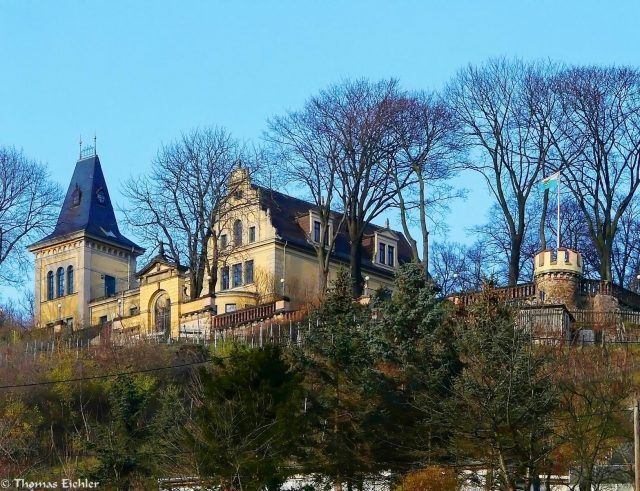
The Wettinshöhe is one of the steep-slope vineyards of the Radebeuler Johannisberg site. It is located in the Zitzschewig district of Radebeul, Saxony, at Auerweg 2/2a (formerly Barkengasse 8). On the hilltop lies the listed building Haus Wettinhöhe or Schloss Wettinhöhe, a former mountain inn that was converted into a representative villa in the 19th century. The extensive property is considered a work of landscape and garden design, located within the Radebeul Historic Vineyard Landscape conservation area.
Description+
The listed property is the "Former excursion restaurant (then villa) with coach house, portal system, enclosure, avenues, and small residential house (so-called gardener's house, No. 2a) at the crossroads and vineyard".
Villa
The two-story central section of the villa, whose architectural style is described as a "free interpretation of German Renaissance," stands with its eaves facing the southern slope. It is the former winemaker's house, later a mountain restaurant. In the main view from the valley, a three-story, rectangular tower with a steep spire stands on the southwest side of the central section, with the south facade of the tower projecting slightly to the south. On the right side of the central section is a two-story cross-wing with a basement and veranda and terrace extensions, also projecting slightly from the facade of the central section.
In the valley view of the central section, there is a central risalit, in front of which is a column and pillar-supported balcony with a grand staircase leading to a terrace in front. The gable of the cross-wing in this view shows a semicircular bay window and an ornate volute gable with windows.
On the simpler rear side of the plastered building, whose windows are framed by sandstone surrounds, the main entrance with a subsequently added wooden veranda and a grand staircase is located in front of the central section.
Coach House Building
Next to the villa stands the coach house building, a tall structure with a brick-covered gable roof and a ventilation attachment. The plastered building is sparsely structured. It has a large, segmental-arched entrance, above which is a coupled round-arched window.
Gardener's House
The gardener's house (No. 2a), located on the access road to the villa, is a single-story building with a brick-covered gable roof, which is hipped over a later added utility extension on the rear side of the building. The plastered building shows a two-story central risalit in the main view, with a coupled round-arched window in the gable.
Enclosure
At the edge of the slope towards the valley, within the enclosure, stands a round-arched portal with a flat gable with side volutes and an obelisk finial, dated to 1880.
As early as the 15th century, the hilltop, then known as Landeskrone, in the Zitzschewig area, as well as the nearby Hohenhaus and Bischofspresse, were owned by the Bishops of Meissen. Since 1758, the name Wettins Höhe has been documented for the hilltop.
Until the mid-19th century, Wettins Höhe was home to a winery with a vineyard and winemaker's house. This belonged to the Kötzschenbroda pastor Johann Samuel Gottlob Flemming (1740–1827) and later his heirs, the sons Joh. Christian Gottlob, a Prussian justice commissioner in Ortrand, and his brother, an advocate in Oschatz. In addition to the residential and winemaker's house and various outbuildings, a well and a wine press, as well as the vineyard, a wood, field, and newly cultivated wine land were documented in 1827.
On part of the property, a wine tavern was built in 1858/1859 by owner Carl Gottlob Wackwitz. He also added a dance hall to the residential house. Additionally, he erected the Konradsturm on the grounds, of which only remnants remain today.
In 1867, innkeeper Carl Heinrich Berger expanded the tavern into a rather square restaurant building, which is now the central section of the villa there (Haus Wettinhöhe). The current vineyard staircase, reaching down into the valley, was also created at this time. The wine tavern license was extended to include the right to provide lodging for travelers and their horses, as well as the right to serve beer and hot meals.
In 1875, the gardener's house was built by August Grosse, whose hipped utility extension was probably added in 1881 by the Ziller brothers.
In 1879/1880, the Prussian Senior Canon and Privy Councillor Alfred Piper (1814–1892) had the building, acquired in 1875, expanded by the master builders Gebrüder Ziller into the representative building he called Schloss Wettinhöhe. Among other things, the two-pointed tower in the west and the cross-wing in the east were created. The valley-side enclosing wall with corner turrets and the coat-of-arms-decorated round-arched portal with the initials AP and the year 1880 were also created. After initial use as a residential house, the building burned down around 1890. After reconstruction, a restaurant moved back into part of the rooms in 1891, a family boarding school in 1898, and from 1899 to 1903, Franz Ludwig Bauer's (1857–1913; "Zuckerbauer") Special Institute for Diabetics was located there, which subsequently moved to Heinrich-Zille-Straße 84 in Niederlößnitz.
In 1908, the property came under compulsory administration. In 1916, the Allgemeine Ortskrankenkasse took it over and made it part of the neighboring men's convalescent home Altwettinshöhe. In 1931 (1935), it was handed over to the Landesversicherungsanstalt Sachsen. This used it as a sanatorium for lung diseases, and from 1940, it became a hospital for prisoners of war. After 1945, it served as a hospital, from 1960 as part of the Lößnitzhöhe tuberculosis sanatorium, then as a retirement home, and from 1970 as a doctors' office building.
From 1997, the building was privately sold and extensively renovated; today it houses apartments. The property has also been divided into several parts, and the other buildings are used for residential purposes.
Take Mobile History with you
You are reading this text for free. Premium adds what matters on the road: descriptions read aloud, sites found through your camera, whole regions taken offline.
- Every description, including the ~17,700 Premium sites
- Audio guide: have descriptions read to you on location
- AR finder: see sites through your camera, with distance and bearing
- Unlimited saved sites
14 days free, then from €2.99 a month. Cancel anytime.
Source: Wikipedia · Licence: CC BY-SA 4.0 · Image: Thomas Eichler
This description draws on the facts documented in the linked Wikipedia article; Wikipedia content is licensed under CC BY-SA 4.0. Wording and editing: Mobile History.
Location: 51.1192, 13.6151