ResidenceNürnberg

Palais Schürstabhaus

Palais Schürstabhaus

Offices

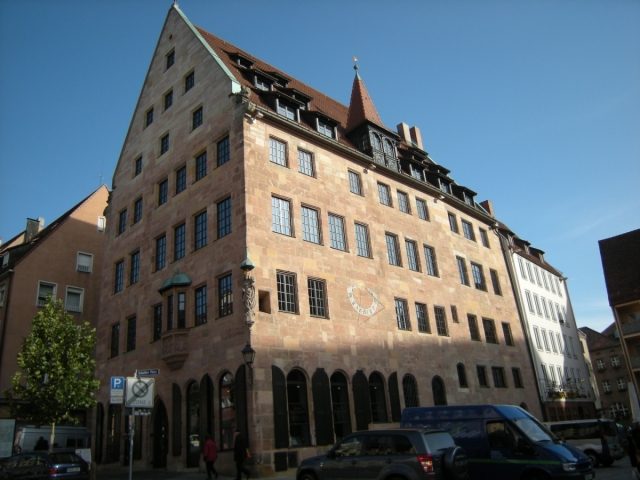
The Schürstabhaus is a patrician house in Nuremberg. It is one of the most important architectural monuments in Nuremberg's Old Town and is a stop on the Historic Mile of Nuremberg.

The Schürstabhaus is located in the Sebalder Old Town, north of Sebalder Platz and east of Albrecht-Dürer-Platz, slightly elevated opposite St. Sebald's Church.

Previously, the Gothic Moritzkapelle stood directly in front of the house, which was completely destroyed by bomb hits on October 3, 1944.

In the 12th century, two individual houses were built on this site, which were only later combined into one house. Until 1328, the owners were "Unholder Ministeriale", from 1328–1478 the house belonged to the Schürstab family, and in 1390 and 1406 (by Erhart d.Ä. Schürstab) the first alterations took place. In 1482/83, the two houses were merged by the new owner Carl Schwerzer and a house chapel was installed. From 1508–1518 the building belonged to the councilor Anton Tetzel and from 1645–1791 to the legal family Fetzer (council consultants). Changes also occurred in the following centuries, but the house was increasingly neglected.

In 1943, the roof truss was destroyed in a bombing raid and later only replaced by an emergency roof. Only in 1995–97 was the house completely restored. During the renovation, it received the (non-historic) name "Schürstabhaus".

The Building+

The 4 to 5-story patrician house has a low, pointed-arch portal on the west side. The different number of floors reveals the two originally separate houses. The building has a three-story roof, on which sits a Nuremberg-style, carved roof dormer with a pointed spire. It contains some special features: the vaulted house chapel (star rib vault) on the ground floor, the staircase with post-Gothic balustrades installed around 1620, and a sundial on the south side. On the southwest corner of the house is a Gothic "Maria with Child" dated 1482; the original is in the Germanisches Nationalmuseum. The sandstone oriel on the west side was only added in 1995-97, based on a model in the neighborhood that was destroyed in the war.

Take Mobile History with you

You are reading this text for free. Premium adds what matters on the road: descriptions read aloud, sites found through your camera, whole regions taken offline.

  • Every description, including the ~17,700 Premium sites
  • Audio guide: have descriptions read to you on location
  • AR finder: see sites through your camera, with distance and bearing
  • Unlimited saved sites

14 days free, then from €2.99 a month. Cancel anytime.

Source: Wikipedia · Licence: CC BY-SA 4.0 · Image: http://schloesserrundschau.de/bayern/schloesser01/nuernberg03.html

This description draws on the facts documented in the linked Wikipedia article; Wikipedia content is licensed under CC BY-SA 4.0. Wording and editing: Mobile History.

Location: 49.4558, 11.0763