Town FortificationDuisburg

Duisburg Town Fortification
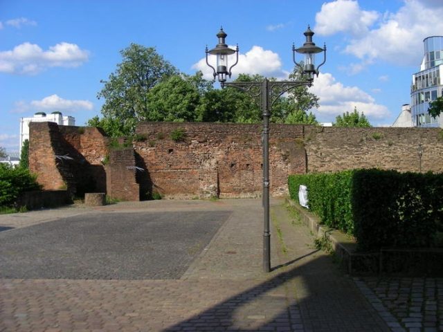
Duisburg Town Fortification

The Fortification can be visited

In the area of Duisburg's old town, remnants of the historic city wall with individual towers can still be discovered. It is considered one of the oldest in the Rhineland; its existence dates back to the 12th century. A complete impression of the defensive structure can be gained from Johannes Corputius' city map (1566).

The city wall formerly ran along the Rhine (today the Inner Harbour) and curved towards the east. The construction of the city wall took place in two phases in the 12th and 13th centuries. The oldest historical evidence stands at the Inner Harbour: built from tuff stone on rubble stone foundations. The wall shows battlements, but no loopholes. In the younger construction phase, bricks were used.

The battlement walk was placed on pointed arch arcades. One of the few remaining examples of the 21 towers, which are clearly visible on the Corputius city map, the Koblenzer Turm, marks the northeastern corner of the best-preserved part of the city wall along the Inner Harbour. In contrast to the semicircular foundations of most towers, the Koblenzer Turm has a polygonal shape. Built of bricks, it had a circumference of 21 meters and towered over the city wall by a good 10 meters.

It therefore had a height of about 20 meters and was thus well suited as a watchtower. The Duisburg city wall rarely had to prove its defensiveness, but it formed a clear boundary to the surrounding area - and it was always a sign of the citizens' independence. Until the 19th century, the Duisburg city wall shaped the cityscape. Only in 1820 was the first house built outside the wall.

In the 1960s, the remaining parts of the city wall still standing at Kuhlenwall were demolished and rebuilt in the old style with the demolition stones. After World War II, 80% of the once 2.4-kilometer-long city wall was still preserved, even though all city gates (Stapeltor, Kuhtor, Marientor, and Schwanentor) had already been demolished between 1815 and 1833.

Take Mobile History with you

You are reading this text for free. Premium adds what matters on the road: descriptions read aloud, sites found through your camera, whole regions taken offline.

  • Every description, including the ~17,700 Premium sites
  • Audio guide: have descriptions read to you on location
  • AR finder: see sites through your camera, with distance and bearing
  • Unlimited saved sites

14 days free, then from €2.99 a month. Cancel anytime.

Source: Wikipedia · Licence: CC BY-SA 4.0 · Image: http://www.wehrbauten.de/thread.php?threadid=564

This description draws on the facts documented in the linked Wikipedia article; Wikipedia content is licensed under CC BY-SA 4.0. Wording and editing: Mobile History.

Location: 51.4379, 6.7646