The Bastion Wall can be visited
FortressFamagusta (Αμμόχωστος, Mağusa)
Famagusta City Wall-Rivettina Bastion
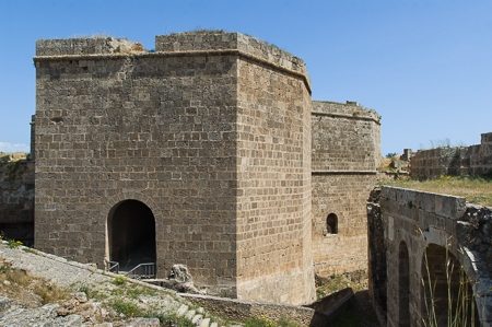
The Famagusta City Walls – Ravelin Bastion is located in Famagusta, Northern Cyprus. It served as the central land gate and protective wall for the port city.
History+
The origins of Famagusta's defensive structures date back to the early 13th century, when kings of the Lusignan house had the first fortifications built. Under King Henri II, construction of the citadel began, and his successors Hugues IV and Pierre II pushed ahead with the work until the Genoese takeover in 1373. The complete city walling was finished during Genoese rule by 1464. The Venetians, who took control in the late 15th and first half of the 16th centuries, expanded the facilities. They named the Ravelin Bastion “Porta di Limisso” and designed it as an outwork with a fortified land gate, which formed the only access to the city from the land side. In 1571, during the Ottoman siege, battles raged in this area, destroying parts of the gate fortifications. During the Ottoman reconstruction, the original access points of the ravelin were sealed, bridges removed, and a new, covered access created, leading through a long passage.
On site+
Visitors enter the city through a long, vaulted passage that was once a gun chamber. Inside, there are branches leading to large casemates, powder magazines, and storage rooms. A steep ramp leads up to the gate platform.
Take Mobile History with you
You are reading this text for free. Premium adds what matters on the road: descriptions read aloud, sites found through your camera, whole regions taken offline.
- Every description, including the ~17,700 Premium sites
- Audio guide: have descriptions read to you on location
- AR finder: see sites through your camera, with distance and bearing
- Unlimited saved sites
14 days free, then from €2.99 a month. Cancel anytime.
Source: whatson-northcyprus.com · Image: http://www.schwarzaufweiss.de/Nordzypern/famagusta-landtor.htm
Text and/or image for this object come from the linked site and are used with the permission of its operators; the linked page remains the copyright of its authors. The legacy catalogue kept text source and image source in a single field, so which part came from there can no longer be told apart entry by entry.
Location: 35.1213, 33.9390