The Gate can be visited
Town Fortification Jülich-Aachener Gate
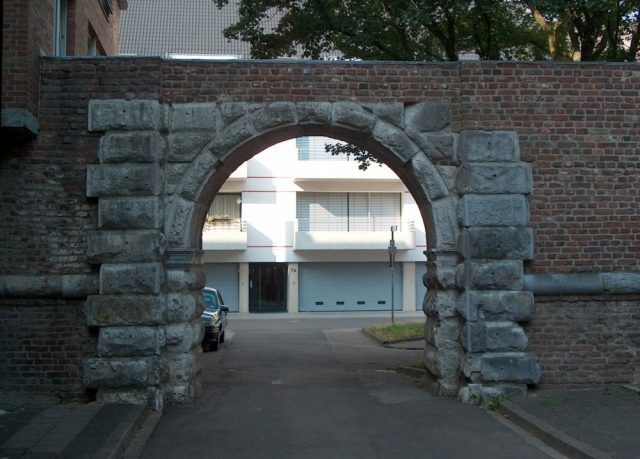
The Aachener Tor, or Rurpforte, in Jülich is a remnant of the early modern city fortifications and was allegedly begun around 1548 during the re-fortification of Jülich after the devastating city fire of 1547. The architect was Alessandro Pasqualini, who was responsible for the expansion of the city and its fortifications. Behind the gate rose the part of Jülich that had remained comparatively undamaged during the city fire, as evidenced by the preserved medieval Hexenturm (Witch's Tower) from the 14th century. For over three hundred years, the Aachener Tor was the main access to the city from the west and was heavily fortified. Above the archway stood a gatehouse made of bricks with bluestone decorations, which bore a stone tablet with the following inscription in a field above the gate until 1798:
„GVILIELMVS DVX JVLIAE, CLIVIAE ET MONTIVM HOC PROPVGNACVLVM IN SALVTEM PATRIAE EXTRVXIT ANNO A PARTVR VIRGINIS MDXXXXVIII“
It identifies Duke Wilhelm V of Jülich-Kleve-Berg as the builder and dates the gate to 1548. A similar tablet was found at the Kölntor.
Recent excavations suggest that the Aachener Tor was initially built in line with the older Hexenturm / Rurtor, and that the old Roman road was temporarily led over the moat with an embankment. A ravelin deviating from the central axis of the southwestern city curtain offered additional protection. It was only during the Spanish period around 1648 that the gate was apparently moved to its current location during construction work on this section of the wall; the eccentric ravelin now served in a reduced form as an outwork of a new, regular, and larger ravelin. Another similarly dimensioned outwork on the southern side of the new ravelin established symmetry. Stylistically, the gate is said to fit better into the 17th century, suggesting that the gate was newly built and only the associated tablet was moved to the new location.
In its maximum expansion phase between 1810 and 1860, access to the city from the west was secured by the bridgehead, the lock bridge over the Rur, city ravelin 2 with its outworks, and the Aachener Tor itself, flanked by city bastions II and III. It represented a veritable bottleneck through which all traffic passing through the city had to squeeze; the same process was repeated in reverse order at the opposite Kölntor. The city was difficult to bypass due to the poor other roads, and the archway was so narrow that obstructions and accidents regularly occurred. Traffic was quite considerable; at the beginning of the 19th century, about two hundred carts daily were counted on the country road that had to pass through the city.
After the abandonment of the fortress in 1860, the city fortifications were demolished between 1859 and 1861, with only minor remnants remaining. The gatehouse was pulled down and the moat filled in. The main thoroughfare was now routed north of the archway, near the route of the old Roman road, which eliminated the need for complete demolition and preserved the archway itself. A section of the blind wall of the city fortifications with its associated moat has also been preserved between the Aachener Tor and city bastion No. III St. Jakob, which has been preserved underground and whose casemates are now used as a beverage market. It is clearly visible that the city fortifications had the same construction features as those of the citadel, but were generally more modest. For example, the walls are only about seven to nine meters high from the bottom of the moat, instead of twelve to fifteen meters at the citadel.
The gate was restored in the 1990s and today has no traffic significance; the roadway that passes through it ends blindly in a parking lot. It is only interesting for pedestrians and cyclists, providing access to the Realschule and the promenade from the city center.
Take Mobile History with you
You are reading this text for free. Premium adds what matters on the road: descriptions read aloud, sites found through your camera, whole regions taken offline.
- Every description, including the ~17,700 Premium sites
- Audio guide: have descriptions read to you on location
- AR finder: see sites through your camera, with distance and bearing
- Unlimited saved sites
14 days free, then from €2.99 a month. Cancel anytime.
Source: Wikipedia · Licence: CC BY-SA 4.0 · Image: http://de.wikipedia.org/wiki/Datei:Aachener-Tor.jpg
This description draws on the facts documented in the linked Wikipedia article; Wikipedia content is licensed under CC BY-SA 4.0. Wording and editing: Mobile History.
Location: 50.9193, 6.3585