The Gate can be visited
Town Fortification Nürnberg-Frauentor

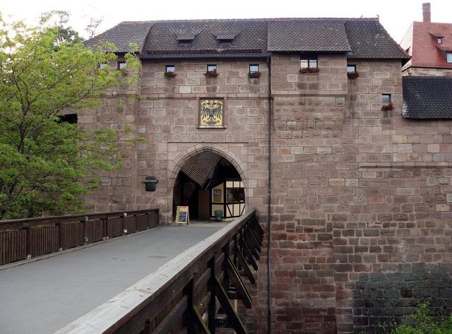
The Frauentor (Women's Gate) was the main gate in the southeast of Nuremberg's city wall. The Frauentorturm (Frauentor Tower) is one of the four prominent round main towers of Nuremberg's city fortifications, its old designation is "Blau Q" (Blue Q).
The Frauentor was named after the Klarakloster (Clara Monastery) located behind it. Through the gate, one could leave the city in the direction of Regensburg and other southeastern locations. Since payments to the gatekeeper are documented from 1386, the construction of the gate must have been completed by this year at the latest.
It replaced the Inner Frauentor of the penultimate city wall, which was demolished in 1498 during the construction of the Mauthalle (Customs Hall). In 1558, the then gate tower was rebuilt by Jörg Unger into the round tower still standing today, and a gate was built next to the tower.
After the construction of the Königstor (King's Gate) in 1849, only outbound traffic passed through the Frauentor. Today, the Frauentor is reserved for pedestrians; the Handwerkerhof Nürnberg (Craftsmen's Courtyard Nuremberg) was established in the gate's Waffenhof (Armory Courtyard).
A sculpture garden was opened in 2004 in the Zwinger (outer bailey) between Frauentor and Sterntor.
Frauentormauer+
The wall section between Königstor and Spittlertor is called Frauentormauer. The alley Frauentormauer, located within the city wall, and the main road Frauentorgraben, located outside, were named after it. In this area, further gates were built in the 19th century: Sterntor, Kartäusersertor, Färbertor, and Jakobstor.
At the western end of the Frauentormauer, between Spittler- and Färbertor, is Nuremberg's red-light district.
Kartäusersertor+
Between Sterntor and Färbertor, an arch of the Frauentormauer was broken through in 1882 and the Kartäusersertor was erected. Today it connects the Ringstraße and the Opernhaus subway station with the Straße der Menschenrechte (Street of Human Rights) and the Germanisches Nationalmuseum (Germanic National Museum).
Jakobstor+
Between Färbertor and Spittlertor, in 1893, the arches of the Frauentormauer were broken through on both sides of the city wall tower "Rotes L" (Red L), the moat was filled in, and the Jakobstor was established. Two further passages for pedestrians were added in 1913.
The City Wall+
The city wall is one of the significant art and architectural monuments of the city of Nuremberg. In the north, the extensive castle complex is fully integrated into the fortifications.
In its long history, Nuremberg was only taken once by military means: in 1945 by the Americans. That this never happened before is due, not least, to the city fortifications, which were considered insurmountable in the Middle Ages.
The Penultimate City Wall+
The first fortifications are already assumed for the 11th century. In the 13th century, the city districts on both sides of the Pegnitz, the Sebalder and Lorenzer settlements, were separately fortified. Of these, on the Sebalder side, besides the castle and the Tiergärtner Tor in the north, the Laufer Schlagturm in the east has been preserved. On the Lorenzer side, the Weiße Turm (White Tower) still stands in the west of the old town.
Remains of the old city moat have been preserved at Grübelstraße (Herrenschießgraben), Peter-Vischer-Straße (Katharinen- und Tiergraben), and Mühlgasse (Klettengraben).
Only from 1320–1325 were both parts connected across the river by walls: in the west, the Henkerturm (Executioner's Tower) and the Wasserturm (Water Tower) still stand, in the east the Schuldturm (Debt Tower) on the island of Schütt.
The Last City Wall+
The last city circumvallation was closed in 1400, was five kilometers long, and formed a skewed parallelogram. Four gate towers were erected at its four corner points.
The city circumvallation was divided into the actual city wall (also called Hohe Mauer - High Wall), the 15-meter-wide, ground-level Zwinger (outer bailey) in front of it, the Zwinger wall rising from the moat, and the dry moat. In total, about 130 moat and wall towers can be identified. The moat, dug around 1430 in view of the Hussite Wars, was on average 12 meters deep and up to 20 meters wide, but never filled with water. In 1452, the construction of the moat was completed.
Access to the city was provided by seven gates: the five main gates with the old Tiergärtnertor and the four new gate towers (Laufer Tor, Frauentor, Spittlertor, and Neutor) as well as two pedestrian passages (Hallertürlein on the north bank of the Pegnitz in the west and Wöhrder Türlein in the east). In addition, there was the Vestnertor leading to the castle. Where the Pegnitz leaves the city, it was impressively spanned by the Fronveste from 1489/94; in the east, the Tratzenzwinger secured the river's entry.
The towers of the city wall were named in 1540 with a combination of colors and letters (cf. also seven-color alphabet): the black section begins in the north at the castle (Luginsland Schwarz A) and extends to the island of Schütt in the east (Turm Schwarz Z). There, the blue section begins with Blau A and extends to Blau X in the south at the Frauentormauer, where it transitions into the red section with Rot A, which leads to Rot Z at the Spittlertormauer in the west, is continued by Grün A, and ends again at the castle with Grün O. These old designations can still be seen on the towers today.
Extensions+
Even before 1500, work began on rebuilding the fortifications and transforming the Zwinger into cannon emplacements: during the so-called "Remparierung," either the Zwinger wall was reduced in height and the Zwinger filled in, or the Zwinger wall was reinforced by a projecting wall with cannon emplacements. Additionally, old Zwinger towers were rebuilt or demolished, and new towers and bastions were erected. The redesign began at the entry and exit of the Pegnitz and ended at the wall north of the Frauentor.
In 1527, the Küblerzwinger (also called Dürerbastei) in the northeast and the Tucherzwinger in the southwest, each as a round bastion, were erected; from 1538–45, the Burgbasteien (Vestnertor-, Große and Untere Bastei) were built in the north and west of the castle.
From 1556–64, the four gate towers were rounded and received their current impressive appearance: the Laufertorturm (Laufer Tor in the northeast), the Frauentorturm (Frauentor in the southeast), the Spittlertorturm (Spittlertor in the southwest), and the Neutorturm (Neutor in the northwest).
From 1611–14, south of the Laufer Tor, the Zwinger wall was renewed and the Wöhrdertor-Bastei was erected (which was demolished in 1871).
After that, the city wall was hardly adapted to the state of defensive technology. On the plan by the draftsman Hans Bien (Bien-Karte), the condition of the wall around 1628/32 can be clearly seen. Already during the Thirty Years' War, Nuremberg was protected by redoubts far beyond the city limits.
Adaptations to Modern Times+
The longer period of economic stagnation until industrialization in the 19th century had a museum-like effect, as with the building fabric of Old Nuremberg. In 1824, the Kettensteg (Chain Bridge), designed by the mechanic Conrad Georg Kuppler, was built in front of the Fronveste; in 1930, massive supports were added, and the entire bridge was renovated in 2010.
Upon its takeover by Bavaria in 1806, the city retained its fortress status. The five main gates were guarded, and three other gates were closed at night. Traffic to the suburbs (e.g., Wöhrd and Gostenhof) grew steadily, but until 1866, only seven more city gates were approved and included in the guard system: in 1848 the Max-, Färber- and Kasemattentor, in 1850 the Königstor, in 1859 the Marientor, in 1863 the Westtor, and in 1866 the Ludwigstor; they were built as neo-Gothic city gates. A request for defortification made by the city in 1863 was still rejected, as in Munich, due to concerns about unrest, the fortress status was seen as a stabilizing factor. On July 12, 1866, defortification was approved, also in anticipation of a Prussian occupation. Subsequently, there was repeated debate about the preservation or demolition of the city wall; for the time being, the king reserved the final decision on any structural change. In 1869, a first section of the wall was demolished, and further demolitions followed.
Due to growing traffic, the seven newly built gates were already demolished again between 1877 and 1891. Further wall breaches were created: in 1869 the Sterntor, in 1871 the Wöhrder Tor, in 1881 the Hallertor, and in 1894, in the form of a bridge construction, the Fürther Tor.
During World War II, the city fortifications were partially heavily damaged by air raids. On October 3, 1944, for example, the Fronveste on the Pegnitz was severely hit during a daytime attack. After the war, the damage was partially repaired.
In the 1960s, parts of the Frauentorgraben in the south were filled in. During the construction of the U2 subway line, this moat section was uncovered again in 1987. Plans for an extensive redesign of the Königstor-/Marientormauer area (Köma project) in 1967/68 were not implemented.
Current State+
Although partly heavily restored or rebuilt, the city wall has remained almost completely intact and surrounds the old town. The largest gap, over 310 meters, is at the Laufer Torturm. The preservation of the wall is an ongoing process; in 2005, for example, the Maxtormauer in the "Küblerzwinger" area was restored.
Behind, on, and in front of the wall and in the partially preserved moat, there are mostly publicly accessible walking paths. The moat itself is largely designed like a park. The mighty bastions west and north of the castle are set up as a castle garden and are generally accessible during the warm season.
At the end of World War II, there were still 88 wall towers; today there are 71, many of which are used by organizations, associations, and private individuals, for example, as a youth center, counseling center, museum, artists' meeting point, and rooms for students, and are thus partly publicly accessible.
In the 20th century, a retirement home was built on the western city wall, near the Fronveste. Further buildings adjoin the two-story sandstone ashlar building with a hip roof. The wall towers Grünes C, D, and E were integrated into the buildings of the retirement home. In the area of the Pegnitz inlet, the Tratzenzwinger extends on the island of Schütt as part of the eastern city wall; behind it rise two towers: Blaues A has been used by the Kreisjugendring (KJR) since 1980, which also operates the Neutor youth home in another city wall tower. Schwarzes Z has housed the Krakauer Haus since 1996.
From 1997–2003, the Museum Turm der Sinne (Tower of the Senses Museum) was planned and implemented in the Mohrenturm (Grünes B) near the Westtor.
From 1997–2006, a moat walk with an internet presence was conceived as part of the Nuremberg Agenda 21.
In 2004, a sculpture garden belonging to the museum and freely accessible during the day was created in the Zwinger at the Frauentorgraben, between Sterntor and Frauentor, not far from the Neues Museum.
The Jakobsturm (Rotes L) at the Jakobstor, built around 1480, was gutted in 2005 under the direction of the city's building department and opened as a hostel for traveling journeymen; five sleeping places, a kitchenette, and a bathroom are available to the wandering journeymen.
Unlike, for example, in Rothenburg ob der Tauber, the image is not characterized by a medieval wall with a walkable battlement. Rather, four thick towers form corner pillars, between which the wall sections extend.
"...There is no other bulwark of this kind and size in Central Europe that has survived the ages. The number and diversity of the structures make the ... circumvallation of the city a textbook of medieval and early modern fortification technology."
Take Mobile History with you
You are reading this text for free. Premium adds what matters on the road: descriptions read aloud, sites found through your camera, whole regions taken offline.
- Every description, including the ~17,700 Premium sites
- Audio guide: have descriptions read to you on location
- AR finder: see sites through your camera, with distance and bearing
- Unlimited saved sites
14 days free, then from €2.99 a month. Cancel anytime.
Source: Wikipedia · Licence: CC BY-SA 4.0 · Image: http://commons.wikimedia.org/wiki/File:2008-05-16_Handwerkerhof_N%C3%BCrnberg_Frauentor.jpg
This description draws on the facts documented in the linked Wikipedia article; Wikipedia content is licensed under CC BY-SA 4.0. Wording and editing: Mobile History.
Location: 49.4472, 11.0811