The Gate can be visited
Town FortificationVolkach
Town Fortification Volkach-Lower Gate
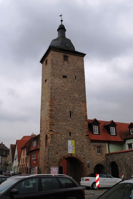
The Volkach town fortifications are still largely preserved. They surround the old town of Volkach and are crowned by the two gates in the south (Upper Gate) and in the north (Lower Gate). The wall runs parallel to the streets Storchgasse, Untere Zwingergasse, Obere Zwingergasse and on the eastern edge of Hindenburgpark.
The Volkach town fortifications were strongly oriented to the terrain from the beginning. The Volkach river and the Main river influenced the course of the fortifications. The location of the town wall did not change over the centuries.
Before the 14th century, a wall of earth and wood protected the citizens of Volkach. Around 1300, the first stone fortification stood around the town. It consisted of a ditch, an outer bailey, and a wall. This lasted for about 250 years and was only replaced in the course of the 16th century. In 1540, the first parts were newly laid out, and in 1568, a new reinforcement of the outer bailey walls was carried out. In 1573, the walls at the Lower Gate were renewed. In 1591, further new constructions followed. In 1608, the defensive system on the Main side was newly laid out. Eight towers were installed here. The completion was in 1644 with the reconstruction of a quarter of the entire complex. Prince-Bishop Julius Echter von Mespelbrunn played an outstanding role in these renewals.
Despite these repairs, the wall was never truly ready for defense. Both Croats and Swedes were able to capture the town during the Thirty Years' War. Afterwards, the fortifications visibly decayed. In the 18th century, the overbuilding of the outer bailey was permitted, and by 1760, the gardens of Volkach were already in the town moat. A complete development of the moat then took place after 1870, although this was limited to the southern, northern, and eastern parts.
The wall also fell victim to the progressive opening. Before 1804, a breakthrough occurred in the west wall. The Weihertor was created. The same happened in 1875 in the east of the town. A northeast opening already existed with the Zeilitzheimer Tor. Industrialization and increasing traffic then also removed the foretowers at the gates and created the present townscape. The town wall of Volkach is listed as a monument by the Bavarian State Office for Monument Preservation under the number D-6-75-174-3. The individual, preserved sections of the wall bear the numbers D-6-75-174- 8, 12, 24, 26, 27, 28, 29, 70, 76, 89, 91, 92, 93, 94, 95, 109, 110, 111, and 122.
Preserved Remains+
The preserved remains of the fortifications date from the 14th or 15th century. Mostly they are remnants of the town wall. Exceptions are the Lower Gate Tower, the Zeilitzheimer Gate, and the Upper Gate. The wall is particularly well preserved in the area of Klostergasse, where battlements and stumps of round towers still exist.
Lower Gate+
The tower of the Lower Gate is one of the landmarks of the town of Volkach. It dominates the lower old town and is also called Gaibacher Gate Tower or Krakenturm.
A town wall around Volkach was first mentioned in 1258. The mention of an Upper Gate in 1328 implied a lower one. In 1577/78, work began on foregate houses for both towers. For the Lower Gate, they were completed in 1580, costing the town 555 guilders. In the course of motorization and increasing traffic, these forebuildings were demolished before 1870.
The tower is empty today, but its facade shows flood marks from various centuries. The Bavarian State Office for Monument Preservation lists the Lower Gate under the number D-6-75-174-70 as a monument.
Architecture+
The tower has six floors. It is square and has a Welsche Haube (Welsh cap) as a finial. On the north side of the tower there is an inscription from 1579.
Take Mobile History with you
You are reading this text for free. Premium adds what matters on the road: descriptions read aloud, sites found through your camera, whole regions taken offline.
- Every description, including the ~17,700 Premium sites
- Audio guide: have descriptions read to you on location
- AR finder: see sites through your camera, with distance and bearing
- Unlimited saved sites
14 days free, then from €2.99 a month. Cancel anytime.
Source: Wikipedia · Licence: CC BY-SA 4.0 · Image: https://commons.wikimedia.org/wiki/File:Gaibacher_Torturm,_Norden,_Volkach.JPG
This description draws on the facts documented in the linked Wikipedia article; Wikipedia content is licensed under CC BY-SA 4.0. Wording and editing: Mobile History.
Location: 49.8674, 10.2253