Town FortificationDormagen-Zons

Town Fortification Zons
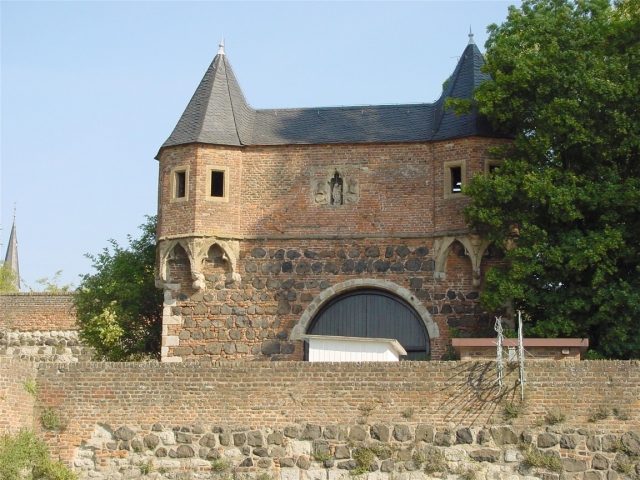
Town Fortification Zons

The City Wall can be visited


Zons is first documented in the so-called Testament of Bishop Kunibert of Cologne, which was written around the middle of the 7th century but is only preserved in a late 11th-century version. This document contains the oldest name forms Zuonizo or Zuonice, whose origin remains unexplained to this day. In a deed of gift from Bishop Heribert of Cologne in 1019, the location of the later Haus Bürgel is given as "Burgula bei Zünce" as the name for Zons.

Archaeological finds from the 7th century indicate a Merovingian settlement in Zons, though its exact location is still unclear. Written sources confirm a manorial estate of the Archbishop of Cologne in Zons at least since the beginning of the 12th century. In the 1980s, archaeological investigations in the Zons castle area uncovered building foundations interpreted as remnants of the lord's private church and thus as part of the manorial complex.

Around the middle of the 13th century, the fortification into a "castrum" took place. Currently, only conjectures based on field names and the terrain situation are possible regarding the location of the older rural Zons settlement. The field name "Im Hofstädtchen" on today's Aldenhovenstraße, not far from the old town, could refer to this settlement, with the intersecting paths at this point also considered a possible indication.

In 1372, the Archbishop of Cologne, Friedrich III. von Saarwerden, moved the Rhine toll from Neuss to Zons. To protect it, fortifications with walls and moats were built, and the town was granted city rights in 1373. The core of the fortress was the heavily fortified Friedestrom Castle, which served to administer and secure the toll and manage the newly created Amt Zons. The apparently planned construction of the toll fortress with its city wall was probably completed in the 15th century.

The rectangular to trapezoidal town is surrounded by a basalt-reinforced wall, extending approximately 300 m in a north-south direction and 250 m in a west-east direction. At the corners are various towers: to the northeast, the rectangular Rhine, Toll, or Peters Tower; to the northwest, the round Krötschen Tower; to the southwest, the round Mill Tower (converted from a defensive to a mill tower (Bärwindmühle) in the late Middle Ages); to the southeast, the Castle Tower; and within the city, on the castle wall, the round Juddeturm (35 m high, 24 m to the eaves, baroque dome 11 m). The name Juddeturm likely refers to the Cologne patrician family Judde.

Two public gates led into the city: the Rheintor in the north and the Feldtor in the west. The former was partially demolished in the 19th century, the latter almost completely. A third outer gate (Südtor), which is the best preserved, provided access from the Zwinger to the outer bailey.

The small town comprised only 124 house plots. The Amt Zons also included the village of Stürzelberg, part of the village of Horrem, and Haus Bürgel, which is now on the right bank of the Rhine. Haus Bürgel and Zons originally belonged together ecclesiastically and judicially. The parish rights over the parish of Bürgel/Zons belonged to Brauweiler Abbey until 1803. Bürgel probably moved from the left to the right bank of the Rhine as early as 1374 due to a shift in the river. The Electoral Cologne Rhine toll town of Zons is considered one of the best-preserved late medieval town complexes on the Lower Rhine. Until 1794, the Amt Zons belonged to Electoral Cologne, bordered to the south by the Jülich enclave of Dormagen (Amt Bergheim), to the southwest by the Electoral Cologne lordship of Hackenbroich, to the west by the Electoral Cologne parish of Nievenheim as part of the Dingstuhl Hülchrath, to the northwest by the Electoral Cologne lordship of Uedesheim (each Amt Hülchrath and Erprath), and on the right bank of the Rhine by the Honschaften Urdenbach and Baumberg in the Duchy of Berg.

Modern Era

From its pledging in 1463 by Archbishop Dietrich II of Moers to the Cologne Cathedral Chapter until 1796, the city and Amt Zons were a kind of subordinate lordship of the Chapter. With the occupation of the Left Bank of the Rhine by French revolutionary troops in 1794, its affiliation with the Electoral Cologne territory ended; Zons became French, initially as a canton and municipality, and from 1798 to 1814 as part of the Canton of Dormagen in the Arrondissement de Cologne in the Département de la Roer. With the Peace of Lunéville in 1801, the entire left-bank territory was also incorporated into France under international law.

In 1815, it was assigned to Prussian territory, and in 1816, the district of Neuss was formed with the mayoralty of Zons, which consisted of the localities Zons, Nachtigall, St. Peter, and Stürzelberg. This was part of the new administrative district of Düsseldorf from 1822. Zons has been a popular excursion destination since around 1900. In 1904, the town received the right to bear its own coat of arms. Since then, Zons has again carried the designation "Stadt" (city), although administratively it remained in the circle of rural communities. With its incorporation into the city of Dormagen, which came into force on January 1, 1975, Zons called itself "Feste" (fortress), and since 1992, due to its historical significance, the place again bears the designation "Stadt," albeit as a purely titular city. As early as 1972, the entire old town was thoroughly renovated through a model project supported by the federal and state governments.

Take Mobile History with you

You are reading this text for free. Premium adds what matters on the road: descriptions read aloud, sites found through your camera, whole regions taken offline.

  • Every description, including the ~17,700 Premium sites
  • Audio guide: have descriptions read to you on location
  • AR finder: see sites through your camera, with distance and bearing
  • Unlimited saved sites

14 days free, then from €2.99 a month. Cancel anytime.

Source: Wikipedia · Licence: CC BY-SA 4.0 · Image: Roland Neubert, Halle (Saale)

This description draws on the facts documented in the linked Wikipedia article; Wikipedia content is licensed under CC BY-SA 4.0. Wording and editing: Mobile History.

Location: 51.1193, 6.8508