School
Museum
Fortress and Castle Jülich

The Jülich Citadel was once part of the Jülich Fortress and is the most important preserved architectural monument in the city, and one of the best-preserved fortresses in the bastion system in Germany. It was built in the years after 1545 as part of an 'ideal city' of the Renaissance and is the oldest citadel north of the Alps. Its master builder was Alessandro Pasqualini. Today it presents itself as a four-pointed, bastioned fortress with a circumference of about 1200 meters. The citadel is surrounded by a 10-meter-deep and 20 to 30-meter-wide moat, partially filled with water, from whose bottom it rises. The complex as a whole still towers about 5–10 m above its surroundings (street level). Access from the city side has been via the Pasqualini Bridge for several years, across the moat, through a postern. The inner courtyard can also be reached from the north through such a tunnel, but the moat is spanned not by a bridge, but by an embankment.
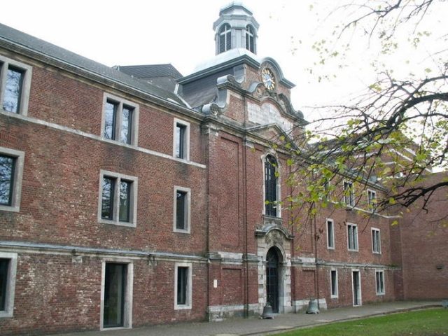
The citadel is today home to the Jülich Citadel Gymnasium and a protected cultural property under the Hague Convention.
A fortress complex similar in many respects from the same period can be found in Berlin-Spandau, see Spandau Citadel. The Bavarian Wülzburg also dates from the same era.
Architectural Description+
With the Jülich Citadel, the architectural idea of the Palazzo in fortezza, the princely seat in an impregnable fortress, much discussed but rarely realized in the Renaissance, was implemented: within the citadel, the ducal residential castle was built, in which Alessandro Pasqualini's 'signature' can also be recognized. This palazzo in fortezza is the oldest in the German-speaking world and is considered the most important example of the High Renaissance.
The citadel and also the no longer preserved city fortifications were designed by the Italian architect Alessandro Pasqualini and executed between 1543 and 1580; they are constructed in the new Italian style. The ramparts and also the economic, barracks, and castle buildings inside the fortress are predominantly built of field-fired bricks and provided with decorations and reinforcements of white bluestone; only the courtyard-side arches of the north and south gates are made of sandstone. Like most such fortresses, the ramparts consist largely of earth, which is enclosed by blind walls, which can be up to five meters thick on the field side. The interior of the rampart is divided by a system of barrel vaults to make it difficult for the contained earth masses to flow out of a breach, for example, to delay the creation of a passable breach through which an enemy could penetrate the fortress. From the inner courtyard, bomb-proof casemates lead down to the cannon courts, which are built into the recessed flank positions of the four bastions, and underground galleries run behind almost the entire outer wall. The wall thickness is highest at the most threatened northern front, at 42 meters; the walls are about 12-15 meters high from the bottom of the moat. They are also sloped to increase their strength and to make projectiles dropped from above bounce off towards the enemy.
The two posterns that pierce the north and south walls are the oldest and date from the time of construction. They are designed in a curved shape to make shooting through difficult. In addition, there are two straight, not publicly accessible posterns in the west and east curtain walls. The Pasqualini Bridge in front of the south postern follows the course of the old moat bridge; in the north, there is still an embankment built after the defortification of 1860. The north and south gates are covered by flanking embrasures to the left of the gate opening.
Shortly after completion, the rampart crowns were still smooth; in the 17th century, an upper rampart system (cavalier) was installed to gain a higher lookout and firing position and more space for gun emplacements. On the southern and eastern sides of the moat, the 16th-century counterscarp has been preserved, which stabilized the far side of the moat wall.
In earlier times, the moat, as it is called by the local population, was often flooded and then submerged about two to three meters deep; today it is almost completely dry. Like the Spandau Citadel, the Jülich Citadel is also built on piles, which was due to the formerly very damp subsoil.
The four Citadel Bastions
The four bastions are:
- Wilhelmus or, according to Prussian numbering, Bastion No. I
- The Wilhelmus Bastion forms the southeastern corner of the citadel, named after its builder Duke Wilhelm V of Jülich-Cleves-Berg. Today, the school sports field of the municipal gymnasium is located on its platform.
- Maria Anna or Marianne, also Bastion No. II
- The Maria Anna Bastion forms the northeastern corner of the citadel, named after the builder's wife. It is the most heavily fortified bastion, as it faces the Merscher Höhe – from there, attacks were preferably launched during sieges due to the elevated position. A sophisticated second line of defense was installed on its platform at the bastion's base on the rampart crown. It consists of a semicircular covered passage with numerous loopholes for small arms and light artillery, which was intended to keep attackers storming the bastion platform at bay; it was reconstructed in the 1980s. On the north face of the bastion, since the siege exercise of 1860, was the Great Breach; it was walled up in the 1980s but is still clearly visible.
- St. Salvator, also Bastion No. III
- The St. Salvator Bastion forms the northwestern corner of the citadel. Together with the Maria Anna Bastion, it was exposed to heavy shelling during the sieges in the 17th century. It was also the target of the bombardments of 1860; one of the breaches made can still be clearly seen on the northern bastion ear.
- St. Johannes, also Bastion No. IV
- The St. Johannes Bastion forms the southwestern corner of the citadel. On it is a gunpowder magazine from the time of Napoleon, similar to the Jülich Bridgehead.
Remarkable is the varied equipment of the four bastions according to the degree of their threat in case of a siege. Maria Anna and Salvator were closest to the Merscher Höhe, the natural direction of attack, and were therefore most threatened; accordingly, they are the most strongly and most modernly developed. Salvator and Wilhelmus, on the other hand, were located near the city fortifications, far from the enemy and behind numerous protective outworks; logically, they are therefore rather weakly developed. On the south curtain wall, the original form of the cannon courts, from which the adjacent rampart section and the opposite bastion face could be fired upon, has been preserved – huge barrel vaults that are open to the front and only offer protection upwards. All other cannon courts have been modernized and feature a mask wall, which also protects them from fire from the front.
Outworks
Remains of the numerous outworks of the citadel are still present:
- Contregarde III in front of Bastion St. Salvator, significant rampart and moat remains along the northwest side of the moat
- Contregarde II in front of Bastion Maria Anna, a flat earthen rampart at the edge of the moat in front of the bastion tip
- Ravelin I (also Ravelin Lyebeck) in front of the east curtain wall, significant casemate remains under the kindergarten, partly converted into an air-raid shelter
- Ravelin II in front of the north postern, rampart and moat remains on both sides of the access road
- Ravelin III (also Ravelin Judas) in front of the west curtain wall, significant earth remains and lock system in the moat area. The ravelin was an earthwork and has not been built over; it could be restored with relatively little effort
- Ravelin IV in front of the city-side postern, size indicated in the paving, remains of the gatehouse
- Lock system in the counter wall under the Bonhoefferhaus with western access to the city moat
- Connection to the city moat south of Bastion Wilhelmus
- Lunette A at the western end of Artilleriestraße behind the Penny market, significant earth remains
Today, the municipal gymnasium and a museum are housed in the citadel.
Historic Buildings in the Citadel
Of the once diverse economic, barracks, and representative buildings, not much remains after numerous sieges, alterations, and the extensive destruction of World War II. Here is a short list of the preserved buildings and building remains:
- In the northeast corner, the remains of a double gate that belonged to a building that apparently underwent various uses during its existence; sometimes it was called a laboratory, sometimes an armory. Today, the two arches with representative bluestone decorations are placed in front of the sports hall.
- On the inside of the north wall, the foundations of barracks, of which nothing but the plinth remains.
- In the northwest corner, a building whose original function is unknown. However, due to the still recognizable, now bricked-up large mullioned windows, it seems to have served representative purposes and was later used for other purposes. At some point, a massive barrel vault was installed, probably for use as a bomb-proof powder magazine, which necessitated a reinforcement of the east wall. Formerly, a Prussian fortress eagle hung here, which once hung above the gate and is now housed in the basement of the castle (museum). A cast of this eagle adorns the gate of the Spandau Citadel. Today the building serves as a warehouse.
- The east wing of the Ducal Residential Castle is discussed further below.
- Two trophy columns south of the south wing opposite the city-side postern mark the spot where there was formerly a passage through the castle building to the inner courtyard. They are made of bluestone and feature rich Renaissance-style decor; they probably once belonged to the cladding of the south wing.
- The gunpowder magazine on the platform of Bastion St. Johannes was built from 1806 onwards (completed in 1811) and is the first building in the city to be built according to the metric system (wall thickness exactly one meter). It is built in the usual manner for such structures, with a massive barrel vault as a roof and thin end walls loosely attached to the main building – in the event of an internal explosion, the walls would have easily collapsed and the pressure escaped, but the barrel vault would have remained standing. For obvious reasons, the least threatened bastion was chosen as the location, far from the Merscher Höhe in the northeast. During the war, the building suffered severe damage and temporarily housed refugees; it fell into disrepair until the 1990s and was then converted into a museum. A magazine about half the size, almost identical in construction, can be found at the bridgehead; it was built simultaneously with the one in the citadel.
- The sandstone inner portals of the north and south posterns are similar in style to those found in Rheydt Castle near Mönchengladbach; they date from the same period and also have the same builder. Above the south portal is a bluestone relief plate with remarkable stonework from the time of its creation, showing the goddess Ceres with a cornucopia along with some other allegorical figures. The plate is a copy; the original is in the museum in the castle cellar.
Castle+
The ducal residential castle was built from the laying of the foundation stone on April 30, 1549, in the style of the Italian High Renaissance and was begun simultaneously with the fortifications. Due to the lack of suitable quarries in the Jülich Börde, it is almost entirely built of bricks, thus connecting to Rhenish and Dutch traditions; only the decorative elements are made of bluestone. The four-winged complex had two floors, four corner towers, one of which was a representative tall tower at the northeast corner, and a chapel in the middle of the east wing. The upper floor was designed as a so-called piano nobile, i.e., for the ruler's chambers. A special feature was the inner courtyard loggia, of which traces of the foundations have been preserved in the inner courtyard to this day. The staircases in the towers are also worth mentioning: they were barrel-vaulted and extremely spacious, and they were richly decorated with stonework. Extensive remains of them are also present, especially handrails and representative doors. Two staircases are completely preserved; they lead to the basement and are not quite as lavishly equipped, but they provide an insight into the appearance of the old staircases. The design of the castle strongly reminds one of contemporary Italian models such as the ducal palace (palazzo ducale) in Urbino, where many similar architectural elements such as the loggia or the staircases can be found and which gives a good impression of what the Jülich castle looked like shortly after its completion. The fact that the castle chapel is not exactly in the middle of the east wing, but is shifted southwards from the central axis, indicates that the reduction of the originally much more generous plan was decided only after construction began, when the foundations of these components had already been laid.
At that time, the castle represented something completely new in the still strongly medieval Rhineland and meant a drastic break with tradition. It served as a ducal residence for both representative and administrative purposes, housing the ruler's chambers and reception rooms (in the east wing) as well as extensive magazine and administrative rooms. This is still evidenced today by the extensive and well-preserved cellar vaults, which survived the destruction of the last war relatively unscathed and extend under the entire castle. The facade was representatively decorated with bluestone elements; for example, there was a continuous triglyph frieze and a rusticated bluestone plinth, and a sundial and rich figural decoration are also documented, of which hardly anything remains today. The inner courtyard had two vaulted entrances, one from the south and one from the north. Only the one in the north, with an extremely rich decoration in the style of Mannerism, has been preserved to this day. A special feature was also the still existing toilets in the east wing, which, instead of the previously common outdoor latrines, were located indoors according to the "free-flight" principle. Also noteworthy is the large ballroom in the west wing, about which no statements can be made today, as well as the still preserved castle chapel, to which a separate paragraph is dedicated.
From 1553, the east wing of the castle was ready for occupancy and was sometimes used by the Duke for longer periods, but construction work on the castle lasted at least until 1561. It was subsequently used rather sporadically; the Duke's main residence was Düsseldorf. When Jülich lost its status as a residential city with the extinction of the ruling house and was merely a fortress and garrison town, the castle also had to adapt to the new tasks. It was converted into a barracks and gutted; instead of the original two floors, it had three from 1738, and the four towers gradually disappeared. Military use lasted until 1944, by which time the castle had been greatly altered and little of its original splendor remained. In 1892, the west wing was demolished except for the cellar vaults; the garrison kitchen was later built in its place.
During World War II, the castle was severely damaged during the heavy bombing raids and fighting in 1944; it burned out completely. Initial securing measures were only carried out in 1964, during which most of the economic and barracks buildings, as well as the armory and about two-thirds of the castle, were unceremoniously blown up without prior architectural survey or rescue of valuable pieces. For example, the preserved Renaissance sundial on the south wing fell victim to this action. In the course of the conversion to the seat of the State Gymnasium, extensive restoration measures were carried out on the east wing, and the basement, which was to serve as the foundation for the new school buildings, was also secured. The restoration of the east wing largely restored the external appearance of the 16th century; internally, however, it is an almost purely functional building containing the school administration and some classrooms, as well as the castle chapel. Little of the rich interior decoration of earlier days remains; only parts of the staircases and a stone fireplace in the conference room bear witness to the old splendor. The facade of the east wing, on the other hand, still hints at the original state, as do various remnants of the old figural decoration in front of the south wing, built as spolia into the inner walls of the ramparts and in a remarkable relief above the portal of the city-side postern. Also noteworthy is the almost completely preserved basement with the museum housed therein and the elaborate systems for compensating for the considerable mining damage.
Castle Chapel+
The castle chapel is undoubtedly the architectural highlight of the residential castle and probably the most valuable building in terms of art history in the entire city and surrounding area. Of all parts of the castle, it is the best preserved or has been restored most lovingly and completely. It was built together with the rest of the castle from 1549, probably originally as part of a larger castle design that was later reduced. Therefore, it is not exactly in the middle of the east wing, but is shifted southwards from it, which indicates that it, along with the northeast tower, belongs to the oldest parts of the building. The Duke at the time strongly sympathized with reformatory ideas, which is why the chapel could easily be the first Protestant church building in the entire Rhineland. Like the east wing, in which it is embedded, the chapel has two floors: the ground floor was for the servants, while the ruling family attended services on the upper floor. Only in the apse of the Jülich castle chapel can Bramante's central support motif, the so-called double window arrangement, still be found today. Here, there are two rows of windows arranged one behind the other, with three large openings on the outside and four narrower ones on the inside, creating an astonishing spatial effect, especially when sunlight falls through. In Jülich, this peculiarity was destroyed during one of the numerous alterations, but rediscovered and reconstructed during the restoration after World War II. It otherwise only exists at St. Peter's Basilica in Rome, but in a built-over form.
Over the centuries, the chapel underwent numerous different uses, serving, among other things, as a storage room and horse stable, as well as – of course – as a house of worship. At times, intermediate floors were installed to make better use of the space. The original Renaissance facade fell victim to a fire in the 18th century and was renewed in the Rococo style in 1768; the form of today's roof turret also dates from this period. After the devastating destruction of 1944, the chapel was completely renovated in the 1970s and opened to the public in 1979; today it serves as a school church and representative concert hall. It was largely restored to the state in which it was first built; only the gallery on the first floor was executed in concrete, and the plaster on the inside is missing. In front of the west portal are two of the original late Baroque bells from the former carillon, which was not reconstructed. They were cast at the behest of Elector Karl Theodor in 1786 and come from the Saarburg bell and cannon barrel foundry of Willibrord Stocky. Both bells are cracked and can no longer be used.
The consecration inscription from 1768 on the west facade of the chapel reads:
DEO AVITERNO ET CAELITIBVS SACRUM, FRONTE NOVA CAROLI THEODORI SPLENDEO IVSSV, EX BVSTIS PHOENIX REDIVIVVS ABIT
(I, a place consecrated to the eternal God and his saints, shine with a new facade at the command of Karl Theodor, as the phoenix rises reborn from the ashes). Some letters of the inscription are highlighted and form a chronogram that yields the year 1768.
Wilhelm the Rich
In the early 16th century, the united duchies of Jülich-Cleves-Berg were one of the strongest regional powers in Northwest Germany; Duke Wilhelm V ruled not only Jülich but also the duchies of Cleves and Berg, as well as the counties of Ravensberg and Mark. In 1539, he also took over the Duchy of Guelders, to which Emperor Charles V also laid claim. In 1543, this led to a war that turned out unfavorably for Wilhelm: he had relied on France as an ally, but France did not lift a finger to help him. The imperial army with its modern artillery easily demolished the outdated ducal fortresses, in particular the Nideggen Castle, considered impregnable, fell victim to them, and Wilhelm had to submit to the Emperor and marry a Habsburg. The Duke was now intent on strengthening his military position and began the construction of several modern fortresses, including Orsoy for the Duchy of Cleves, Düsseldorf for the Duchy of Berg, and Jülich for the Duchy of Jülich, the latter two also intended to become his residential cities and received corresponding residential castles. Jülich had been spared in the war, new city fortifications had been started, but Wilhelm wanted a completely new city, and so he engaged the Italian master builder Alessandro Pasqualini, who had previously worked in the Netherlands. He now supervised the expansion of Düsseldorf and Jülich as fortresses, as well as the construction or renewal of the castle buildings there. In 1547, almost the entire city burned down; whether by accident or arson could never be fully clarified. In any case, the way was now clear for a completely new ideal city layout of the Renaissance, including a mighty fortress.
The original design envisioned the citadel covering the entire north side of the city, making it about twice as large as actually executed. Lack of funds dictated a reduction, and both the castle and the citadel had to be scaled down. Construction took about thirty years; by around 1580, the city fortifications and the citadel were completed. The entire street system of the city, laid out as an irregular pentagon with its own fortifications, was designed so that it could be dominated from the citadel. Lines of fire extended from the citadel across the city to prevent uprisings by citizens or use by enemy soldiers – the citadel was the center of power in the city.
Citadel as Fortress and Garrison
In 1610, as part of the Jülich-Cleves War of Succession following the extinction of the ducal house, the city, occupied by imperial troops, was first besieged by an army of the Dutch States General (→ Siege of Jülich (1610)). The fortress was relatively quickly subdued, as there were not enough supplies and the garrison apparently had not seriously expected an attack. Observers from many countries followed the progress of the siege of what was then the most modern fortress in Europe. The United Duchies were divided, and Jülich, along with Berg, went to the House of Palatinate-Neuburg. This division was, of course, provisional; for the time being, the city remained in the hands of the States General. In 1621, a second siege followed by Spanish troops, who wanted to wrest the city back from the Dutch. The besieged offered tenacious resistance, the fighting lasted through the winter, and only in the spring of 1622 did the fortress capitulate. The Spanish occupiers remained until 1660, after which the city fell to the Palatinate and finally the Bavarians, who greatly expanded the fortifications in the 17th and 18th centuries.
The castle was no longer needed for representative or administrative purposes and was converted into a barracks. Towards the end of the 18th century, however, the fortress was in a poor general condition and was surrendered to the French without a fight in 1794, who forged ambitious expansion plans and partly implemented them. Jülich was to become an important staging fortress between the Rhine border and the French mainland and serve as a fallback for imperial armies operating in the area. Numerous new outworks were begun, especially in front of the citadel; a circle of seven lunettes was placed around the city, five of which were in the area of the citadel, in addition to the newly created bridgehead. Napoleon's defeat in Russia and at Leipzig in 1813 prevented the completion of all expansions, and in 1814, the city, which still housed a French garrison, was besieged over the winter by advancing Prussian, Danish, and Mecklenburg units.
In 1815, the city and fortress became Prussian, and the new masters completed the expansions begun by the French. In 1860, the fortress was abolished, and a large-scale siege exercise of the Prussian army took place, during which the new rifled breech-loading weapons (cannons and rifles) were extensively tested. The insights gained benefited the Prussians in the sieges during the Franco-Prussian War. The city fortifications were removed except for minor remnants; only the citadel and the bridgehead remained. In the course of the defortification, the bridges over the moat were also demolished and replaced by embankments; in the north, the embankment built at that time is still preserved.
After the Defortification
Until 1944, the citadel housed a non-commissioned officer preparatory school, with an interruption in the 1920s when Belgian and French occupation troops were quartered there. During the occupation, the fortress was known as Quartier Charlemagne. In the moat, shooting ranges were located in the northern cannon courts of the Wilhelmus and St. Johannes bastions, with bullet traps at the northwestern and northeastern ends of the moat. The north side of the citadel, with the space formerly occupied by its outworks, between the edge of the moat and today's Artilleriestraße, was used as an artillery training ground by the garrison.
During World War II, the casemates of the citadel served as air-raid shelters. During the bombing raid on November 16, 1944, it was severely damaged, all buildings burned out, and two direct hits by air mines into the casemates of Bastion St. Johannes killed numerous civilians who had sought refuge there. Further bombing raids, artillery shelling, and street fighting continued the destruction. After the war, the citadel fell into a long slumber and was generally avoided and hushed up; there were even demolition plans. In 1964, the ruin was provisionally "secured," but unfortunately, in the course of these works, most of the economic and barracks buildings, as well as the armory and about two-thirds of the castle, were blown up without much ado. At the end of the 1960s, the citadel was chosen as the new seat of the State Gymnasium, which needed a larger home due to the post-war baby boomers and numerous immigrant children. The preserved east wing was adequately restored, and the rest of the castle was "completed" in a modern form. In 1972, the new building with an attached sports hall and institute building could be occupied by today's Jülich Citadel Gymnasium; the platform of Bastion Wilhelmus and the rampart crown of the east curtain wall have since served as a sports field. During the 1980s, the east and north curtain walls and Bastion Maria Anna were restored with little care; large parts of the masonry were simply torn down and replaced with concrete and cheap bricks. In the 1990s, a rethinking gradually began, and the north and west curtain walls and Bastions St. Salvator and St. Johannes received a first-class restoration. By 1993, the embankment in front of the south curtain wall was removed and replaced by the Pasqualini Bridge, which recreates the old wooden bridge from the fortress era in steel. The powder magazine on the bastion platform of St. Johannes was also thoroughly renovated and became the seat of a museum. In recent years, the citadel has increasingly become a tourist and cultural center of the city, which was particularly promoted by the 1998 State Garden Show, whose center, in addition to the bridgehead, was also the citadel. These two preserved fortifications are, with few exceptions, the only buildings in the city that survived the total devastation of World War II, which further enhances their importance.
Mining Damage
The lowering of the groundwater level due to the many surrounding open-pit mines of Rheinbraun/RWE has caused the fortress's foundations to dry out and is causing significant mining damage due to flowing sand and yielding foundations. Excavations in the 1990s revealed that the citadel, at least in large parts, stands only on sand, which in places begins to flow due to the sinking groundwater level, causing cracks and fissures in the ramparts. A steadily growing fault runs from northwest to southeast across the citadel, with the southwestern plate continuously sinking. It creates a clearly visible crack in the left face of Bastion St. Salvator, passes under the Pedagogical Center and the south wing of the castle, and leaves the fortress through the left face of Bastion Wilhelmus. Already in the 1980s, the south wing of the castle had to be extensively secured; it was completely sawn through to insert an expansion joint, and the separated part was placed on a complex system of hydraulic dampers and steel springs; similar dampers exist under the Pedagogical Center to prevent deformation of the building. The mining damage is becoming increasingly extensive; the difference in level between the western and eastern parts of the south wing is now about 50 cm, and burst window panes in the Pedagogical Center led to this building also being cushioned. The cracks in the ramparts are particularly noticeable at Bastion Wilhelmus; the level difference that has now arisen can also be clearly seen at the foundation and the cordon stones of the ramparts. At Bastion St. Salvator, the situation is not as obvious due to the more recent restoration, but there is a certain risk of collapse in the casemates of both affected bastions.
Take Mobile History with you
You are reading this text for free. Premium adds what matters on the road: descriptions read aloud, sites found through your camera, whole regions taken offline.
- Every description, including the ~17,700 Premium sites
- Audio guide: have descriptions read to you on location
- AR finder: see sites through your camera, with distance and bearing
- Unlimited saved sites
14 days free, then from €2.99 a month. Cancel anytime.
Source: Wikipedia · Licence: CC BY-SA 4.0 · Image: http://www.wehrbauten.de/thread.php?threadid=570
This description draws on the facts documented in the linked Wikipedia article; Wikipedia content is licensed under CC BY-SA 4.0. Wording and editing: Mobile History.
Location: 50.9256, 6.3601