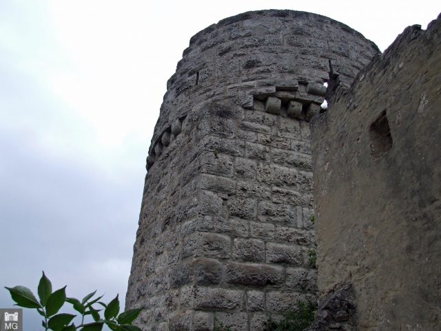
The remains of the Castle can be visited
Hotel
Restaurant
Arnsberg Castle

The ruin of the hilltop castle lies on a mighty rock formation at the edge of the valley, an impressive dolomite massif in the Altmühl Valley, and approximately 120 meters above the village. It is thus located in the heart of the Altmühl Valley Nature Park. Not far from the castle in the valley, the Schambach Valley flows into the Altmühl.
Since the 12th century, Arnsberg was owned by the noble free lords of Erlingshofen, who subsequently named themselves after the place. In 1087, Gozwin von Arnsberg is mentioned as a witness. The family moved to Heideck in the 13th century and changed their surname again. By 1278, Arnsberg Castle was already in the possession of a Gottfried von Heideck, but the castle was referred to as an Eichstätt fief. The family had apparently submitted to the Prince-Bishopric of Eichstätt early on.
Even before 1305, Gottfried IV sold the lordship to Duke Otto III of Lower Bavaria. In 1328, the Dukes of Bavaria pledged the castle for the first time. One of the pledge holders around 1350 was the minnesinger Hadamar III von Laaber. From 1365, the Frauenhofer family held the pledge. This pledge relationship ended around 1416 with a dispute; the Frauenhofers were subsequently outlawed after being accused, among other things, of highway robbery. Duke Ludwig the Bearded had to forcibly take the castle from the "robber knights."
In 1473 and 1475, the Prince-Bishopric of Eichstätt reacquired its old castle from Duke Albrecht, which was then pledged to Sibylla von Heideck. The complex subsequently remained Eichstätt property until secularization and occasionally served as a hunting and summer residence for the bishops. In 1663, the mountain fortress was restored; in 1763, parts had to be demolished.
Subsequently, the buildings began to decay, as only the outbuildings were still in use. This decay accelerated after secularization, so that in the mid-19th century, further extensive demolitions were initiated for safety reasons. The abandoned castle was a welcome quarry for the inhabitants of the village and the surrounding area, so much more material was removed from the masonry than was actually necessary. As early as 1868, Kugler, the author of the booklet "Die Altmühlalp" (Ingolstadt), lamented the loss of this "ornament of the region," whose castle chapel of St. George had already collapsed in 1798. Further loss of substance occurred due to several rockfalls, for example in 1926 and 1931.
Description+
The well-preserved outer bailey is used as a hotel; of the main castle, remnants of walls and the stump of the keep have been preserved. The ruin of the main castle is freely accessible.
The outer bailey projects onto the high plateau and is secured by an angular neck ditch. The outer walls of the buildings still seem to contain the remains of the high medieval curtain wall of the outer bailey. In front of it lies a narrow zwinger, whose masonry is still partially preserved as a retaining wall for the outer bailey terrace.
The western part of the outer bailey (former castle chapel) lies on a spur of the castle rock, which drops steeply into the valley. The old gate is located on the southwest edge and was placed in a recess of the wall for fortification (military engineering) reasons. The two-bay bridge dates from the Baroque period. The eastern castle access is relatively modern; it allowed access to the two farms that were operated in the outer bailey until the 20th century.
Even more spectacularly, the remains of the core castle (13th century) lie on an isolated rock reef that projects to the northwest. The oval curtain wall of carefully executed limestone masonry is still up to 4 meters high, but the northeast part was lost in a rockfall.
The preserved stump of the keep rises at the southeast corner directly above the curtain wall near the former gate (southeast). The tower's footprint is an irregular pentagon, which transitions into a circle after about seven meters. The only partially preserved circular structure projects slightly on corbels; the northwest side is completely missing. In total, the tower is still about 10 meters high and consists of dolomite ashlar at the bottom (max. 0.60 x 1.40 meters); the stones of the upper floor are somewhat more manageable. The inner shell also consists of ashlar masonry; the basement is buried.
Take Mobile History with you
You are reading this text for free. Premium adds what matters on the road: descriptions read aloud, sites found through your camera, whole regions taken offline.
- Every description, including the ~17,700 Premium sites
- Audio guide: have descriptions read to you on location
- AR finder: see sites through your camera, with distance and bearing
- Unlimited saved sites
14 days free, then from €2.99 a month. Cancel anytime.
Source: Wikipedia · Licence: CC BY-SA 4.0 · Image: Mobile Geschichte
This description draws on the facts documented in the linked Wikipedia article; Wikipedia content is licensed under CC BY-SA 4.0. Wording and editing: Mobile History.
Location: 48.9277, 11.3790