The remains of the Castle can be visited
CastleKarlstadt
Karlsburg Castle
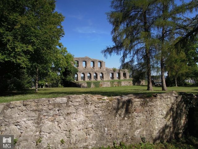
The Karlsburg is the ruin of a spur castle destroyed in 1525, located on a wide rock spur on the left bank of the Main in the district of Mühlbach opposite the town of Karlstadt, approx. 25 km northwest of Würzburg. North below the castle was the associated valley settlement in the district of today's Karlburg.
Geographical Location+
It is a very conveniently located and traffic-determining position in the old Franconian settlement area. The Main valley widens here into a flat basin, rising towards the west. Important trade routes to the centers of the Franconian-Carolingian Empire ran along the Main and in a west-east direction. They crossed the river here at two fords, about two kilometers apart. The complex of castle and settlement formed the last stage on the way upstream to Würzburg, the former seat of Duke Heden and episcopal city since 741/42. Also a day's journey away downstream are Neustadt Monastery and Hammelburg to the north. This shows the important position of the Karlsburg on the way through what was then East Franconia.
Written Tradition+
The first mention of the Karlburg settlement complex in 741/42 is directly related to the founding of the Diocese of Würzburg. The Carolingian mayor of the palace, Carloman, donated to the diocese founded by Boniface, in addition to 25 royal proprietary churches, a Marian monastery with associated goods and rights in the villa Karloburgo, as reported by three later confirmation documents. An old road led from Karlsburg and Karlburg, among other places, via Duttenbrunn, Unterleinach, Oberleinach and Hettstadt to Marienberg in Würzburg. In a second donation in the same context, King Pippin the Younger handed over to the first Würzburg bishop Burkard in 751/53 the castle and royal court with the associated fiscal district and all income to be obtained therefrom (castellum ... Karloburg ... cum fisco regali). By the middle of the 8th century at the latest, there was thus a central place with fortifications, a royal court, and a monastery, which was initially in royal hands or those of the Carolingian mayors of the palace and only thereafter transferred to the diocese. The exact founding date of the castle cannot be derived from the sources. It remains unclear whether it was built only in Carolingian times, possibly under Charles Martel, the grandfather of Emperor Charles, or already in late Merovingian times, perhaps under the protection of the Hedene. Information about the appearance and function of the castle, where Charlemagne is said to have frequently stayed, is also missing. Historical records already characterize Karlburg as an important central place in the early medieval regional history of Main Franconia. The Karlsburg, mentioned as castrum in 1286, met its end in the Peasants' War, when it was burned down by peasants between May 15 and June 3, 1525.
Archaeological Excavations+
Archaeological excavations at the castle took place in 1971/72 and 1974/75 under the direction of Klaus Schwarz. In 1994, a smaller trial excavation was carried out again. Significant insights were also provided by aerial photographs taken in 1992 of the oldest fortification, which is barely visible above ground.
The Development of the Karlsburg from the 8th to the 16th Century+
The evaluation of the excavations by Peter Ettel resulted in a division of the castle's building history into four phases.
Phase A – The Carolingian complex of the early Würzburg episcopal period (construction around the middle of the 8th century)+
It had an extension of about 125 × 120 m with approx. 1.3 ha of inner area and was defended by a 5.30 m wide, formerly 1.90 m deep pointed ditch, which closed off the spur in an arc shape. Behind the inner edge of the ditch, a mortar wall ran with very high probability, one of the earliest such fortifications in Southern Germany. In the smaller trial trenches inside the castle complex, various post settings and settlement pits were found, testifying to intensive construction and use. Among the finds, a presumably early medieval, decorated bone plate is particularly noteworthy. It probably comes from a small box and is considered proof of the presence of a socially elevated class of people at the castle.
Phase B – The Ottonian complex (construction around 900 – 1st half of the 10th century)+
The smaller fortification of the Carolingian castle was abandoned, the ditch filled in, and the fortified area expanded to 1.7 …
Source: Wikipedia · Licence: CC BY-SA 4.0 · Image: Mobile Geschichte
This description is a machine translation of an excerpt from the linked Wikipedia article. The source text was written by its authors, the translation is by Mobile History; like the original it is licensed under CC BY-SA 4.0.
Location: 49.9615, 9.7573