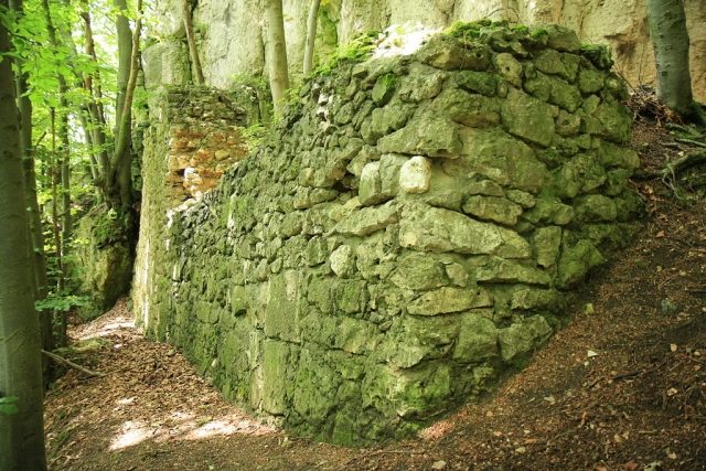
The remains of the Castle can be visited
Stierberg Castle
The Stierberg castle ruin was a high medieval noble castle above the village of Stierberg, a western district of Betzenstein in the Upper Franconian district of Bayreuth in Bavaria.
The upper castle of the ruin is freely accessible; a large part of the lower castle is privately owned by the Thilo Glas family from Erlangen and cannot be entered.
The Stierberg castle ruin is located in the Franconian Switzerland-Veldenstein Forest Nature Park on the Schlossberg (east - 559 m, northeast - 596 m and southwest peak 594 m above sea level) near the village of Stierberg, which is about 2.3 km west-southwest of the church in Betzenstein. It is located southeast of the village on the mountain saddle between the two highest Schlossberg peaks at about 580 m above sea level.
The hilltop castle consisted of an upper castle on a rock ridge of the mountain saddle and a lower castle at the western foot of the ridge. The ruin is best reached from the village on a signposted path.
Nearby, to the east, you can see Betzenstein Castle. To the north are the Leupoldstein castle site and the Leienfels castle ruin. South of Stierberg stood the castles of Wildenfels, Strahlenfels, Spies, and Riegelstein.
The name Stierberg first appeared in 1187 with the mention of "Otnand de Stierberc", a Bamberg cathedral canon. In 1188 and 1216, a "Poppo von Stierberg" also appeared, probably a brother of Otnand. It is unlikely that the Bamberg ministerials built the castle. The family died out between 1281 and 1285, and the castle fell to the Diocese of Bamberg.
In 1308, the castle was first mentioned in a will by the noble Gottfried von Schlüsselberg. In 1323/27, it appeared in an episcopal urbarium as a "castrum" of the Diocese of Bamberg. However, Stierberg Castle had already passed to the Leuchtenbergers, who were related to the Schlüsselbergers. The castle probably fell to the Leuchtenbergers through mortgaging and was no longer redeemed by the Diocese of Bamberg. Landgrave Ulrich von Leuchtenberg had enfeoffed it to Archbishop Balduin of Trier in 1316, probably to secure his title of ownership against the Diocese of Bamberg.
In 1356, the castle was sold to the Bohemian Emperor Charles IV. In 1400, as a result of their feud with the Diocese of Bamberg, the Leuchtenbergers had to sell their fief to the Nuremberg patrician Peter Haller, but in 1407 the castle was back in their hands. In 1417, it had to be definitively sold by the Leuchtenbergers to Count Palatine Johann von Neumarkt-Neuenburg.
During the Landshut War of Succession, the castle was captured by the Nurembergers on July 2, 1504, but in October 1504, the Palatine captain Ludwig von Eyb the Younger of Hartenstein recaptured it. This caused damage to the lower castle. Due to the victorious outcome of the War of Succession, the castle came to the Nurembergers in 1505, who repaired it until 1515 and made it the seat of a bailiwick.
The Second Margrave War brought the end of the castle. In 1553, it was shelled, conquered, and subsequently burned down by Margrave Albrecht Alcibiades. Although work for a reconstruction began in 1555, it was stopped shortly thereafter. The bailiff was to find a seat in Betzenstein, making Stierberg Castle superfluous. During the 16th century, repairs were still carried out on the lower castle, and a vogt's house, a granary, and various farm buildings were built. Due to dilapidation, the vogt's house was replaced by a new building in 1778, and the granary disappeared again in 1799.
In 1806, considerable remains of the castle still existed, but in the 19th and 20th centuries, there were great losses, probably because it was used as a quarry.
Description of the Castle Ruin+
The Stierberg Schlossberg is a long, wooded rock ridge that stretches from northeast to southwest. The ridge mostly drops vertically on its sides. In front of the southwestern end there is a saddle that separates part of the rock ridge from the rest of the mountain. This ridge was used for the construction of the upper castle. It drops vertically by up to approx. 20 meters on almost all sides; only the access side in the northeast rises steeply by approx. 18 meters. Another ascent was probably in the southeast, from the walled area in front of the southern exit of the castle cave. There, a steep, gorge-like ascent led upwards via stairs.
On the upper castle, with an area of approx. 60x30 meters, only a few remains of the curtain wall and a tower, presumably the keep, are preserved. The wall remains only have their ashlar facing in the south of the upper castle and on the northwest side of the tower, but this is also threatened by decay. A large wall remnant, presumably of a building, still stands on the northeast side of the upper castle; it is approx. 11 meters long, 6 to 8 meters high and 1.3 meters wide and has two buttresses and a corbel on its exterior. This wall remnant probably belonged to the large palas in the southeast part of the upper castle. Kunstmann suspects a small palas next to the large one. Other buildings of the upper castle were the already mentioned tower and a cistern, of which nothing more can be seen. The ascent was in the northeast of the rock ridge and started from the lower saddle, presumably via stairs, through a gatehouse or a gate tower, as can be seen in an engraving by L. Schlemmer from 1799.
The lower castle was located approx. 20 meters below the upper castle at the northwestern foot of the rock ridge and in the saddle to the north. Not much of it can be seen anymore. Now, the vogt's house from 1778 stands in the area of the lower castle. Of the former granary, only traces of the terrain and a foundation wall remain. The access road from the village of Stierberg in the northwest formed a gate alley in the area of the lower castle. Formerly, a gatehouse or gate tower also stood at the entrance to the lower castle. In the south of the lower castle, a second cistern can still be seen. At the northern end of the lower castle, a widely visible round tower stands on a rock tower. The tower consists of rubble masonry and has a diameter of 5.5 meters, a wall thickness of 1.3 meters, and a height of six meters. Its segmental arched entrance towards the lower castle was only accessible by a ladder. The tower was covered with tiles, as tile remnants below the tower show. It served to defend the castle against attacks from the north and was included in the surrounding wall of the lower castle.
A special feature is the castle cave. The natural cave was artificially extended and probably served, among other things, as the castle's cellar. It runs through the rock ridge of the upper castle and had three entrances: a northern one in the area of the lower castle, one in the south of the rock ridge, and one in the west of the rock ridge. The opening in the west was walled up except for a notch, but is now completely sealed. In front of the southern exit, which is walled up except for a small square opening, a shield wall-like fortification was built at a distance of approx. 2 to 4 meters. Whether it had an opening to the outside is unclear. It forms a small forecourt, created by the wall and the rock ridge, from which the aforementioned gorge-like second ascent led up to the upper castle. The ascent led between the rock ridge and a projecting rock tower on the slope of a short saddle connecting the rock ridge and the rock tower, up steep stairs. The purpose of this structure is unclear. Perhaps it served to attack an enemy who had penetrated the lower castle from behind, or to bring supplies from the cave cellar to the upper castle, perhaps even by elevator. A tower probably also stood on the rock tower.
Take Mobile History with you
You are reading this text for free. Premium adds what matters on the road: descriptions read aloud, sites found through your camera, whole regions taken offline.
- Every description, including the ~17,700 Premium sites
- Audio guide: have descriptions read to you on location
- AR finder: see sites through your camera, with distance and bearing
- Unlimited saved sites
14 days free, then from €2.99 a month. Cancel anytime.
Source: Wikipedia · Licence: CC BY-SA 4.0 · Image: http://de.wikipedia.org/wiki/Datei:Burgruine_Stierberg,_Mauer_vor_der_H%C3%B6hle.JPG
This description draws on the facts documented in the linked Wikipedia article; Wikipedia content is licensed under CC BY-SA 4.0. Wording and editing: Mobile History.
Location: 49.6776, 11.3876