The Fortress can be visited
FortressKoblenz-Karthause
Fortress Koblenz-Feste Kaiser Alexander
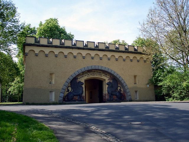
The Feste Kaiser Alexander (Fortress Emperor Alexander) was part of the Prussian Fortress of Koblenz and the main work of the Feste Kaiser Alexander system. The fortress, located in today's Karthause district of Koblenz, was completed in 1822. After its demolition in 1922, the last large remnants of the fortress were blown up in 1964. Only the main gate, the so-called Lion Gate, remains of the gorge redoubt, and parts of the crenellated wall west of the gate have been preserved. The entire complex was about three times larger than the Ehrenbreitstein Fortress, which was built at the same time. It was named after Tsar Alexander I, an ally of Prussia in the Holy Alliance against Napoleon during the Wars of Liberation.
During the First Coalition War in 1792, the city of Koblenz and Ehrenbreitstein Fortress were defended by the Electoral Trier General Clemens Freiherr von Wenz. Against the advancing French Revolutionary Army under General Adam-Philippe de Custine, the then Prussian Major Ernst von Rüchel had redoubts erected above the city near the Carthusian monastery. Fearing the French, farmers initially tore down the fortifications again, but after their reconstruction, they were occupied by 160 soldiers. Thirty years later, the massive Feste Kaiser Alexander was built here.
The work, already projected in 1814 by General Ernst Ludwig von Aster, was built between 1816 and 1822 according to plans by the engineering officer Claudius Franz Le Bauld de Nans. On November 24, 1818, the fortification on the Karthäuserhöhe was named after Tsar Alexander I. With a size of 550x500 meters, it was the largest complex within the Fortress of Koblenz.
To improve the accommodation of soldiers, the Spitzberg Barracks were built below the eastern glacis of the fortress starting in 1870, initially as barracks made of temporary structures, later as half-timbered barracks. The Feste Kaiser Alexander system with its outdated fortifications was abandoned in 1903, but the facilities remained under military administration for the time being. On the huge parade ground south of the Feste Kaiser Alexander, the first airship Parseval 3 landed on October 7, 1909. This led to the Koblenz-Karthause airfield, officially opened in 1913, where the first aircraft landed in the same year as part of the Prince Heinrich Flight. The airfield was closed in 1965, and flight operations were moved to Winningen with the opening of the Koblenz-Winningen airfield in 1971.
After the First World War, the Feste Kaiser Alexander, like the other Koblenz fortifications, had to be de-fortified in execution of Article 180 of the Treaty of Versailles. Very extensive works were planned, such as the removal of all caponiers, batteries, and powder magazines, as well as the destruction of various underground passages and rooms. All ditch walls were destroyed, and the ramparts and ditches were breached in twenty places. The de-fortification works on the fortress began around March/April 1922 and were approved on December 22 of the same year by representatives of the Inter-Allied Military Control Commission, who had previously observed the works with suspicion. During the French occupation as part of the Allied occupation of the Rhineland, the fortress was referred to as Fort Verdun.
In addition to an extensive landscape of ruins, the core work in the form of two self-contained redoubts and the adjacent so-called Lion Gate, the former main entrance of the Feste Kaiser Alexander, remained. However, since the depicted animals are griffins, the name is misleading.
The area was partially regulated by the city of Koblenz already during the de-fortification works, as a new residential area was to be developed here. However, the property only came into the possession of the city on January 1, 1934; settlement began shortly thereafter. At the end of the Second World War, construction activity was initially halted.
Source: Wikipedia · Licence: CC BY-SA 4.0 · Image: http://de.wikipedia.org/wiki/Datei:L%C3%B6wentor_Koblenz_2013.jpg
This description draws on the facts documented in the linked Wikipedia article; Wikipedia content is licensed under CC BY-SA 4.0. Wording and editing: Mobile History.
Location: 50.3478, 7.5800