The roman town can be visited
Ancient BuildingXanten
Roman Town Colonia Ulpia Traiana and Tricensimae
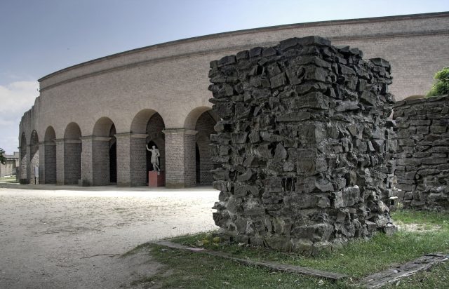
Colonia Ulpia Traiana (CUT) was a Roman city in the immediate vicinity of modern-day Xanten (North Rhine-Westphalia). Colonia Ulpia Traiana was founded by Emperor Marcus Ulpius Traianus and named after him. As a Colonia, it was one of about 150 cities in the Roman Empire that possessed this highest city right and were considered "images of Rome". Ulpia Traiana was, after Claudia Ara Agrippinensium (modern-day Cologne) and Augusta Treverorum (Trier), the third largest Roman city north of the Alps and a main center of Germania Inferior. Its public buildings represented the high status of the city, which formed the center for a wide surrounding area.
Based on archaeological finds, the origin of the site can be traced back to the 4th century BC. Further finds date from the 3rd century BC, but evidence for continuous settlement is lacking from the 2nd and 1st centuries BC.
In 13/12 BC, Drusus had the legionary camp Vetera built on the nearby Fürstenberg, which also served as a base for campaigns into Germania east of the Rhine, which in 8 BC led to the resettlement of the Germanic tribe of the Sugambri, thereafter called Cugerni, into areas west of the Rhine, and the founding of the settlement that would later be elevated to Colonia Ulpia Traiana.
The name of this settlement has not been handed down, but it is suspected that it was called "Cugernorum", similar to the Batavian Batavodurum (modern-day Nijmegen). Due to its proximity to Vetera I, Cugernorum developed into a comparatively prosperous trading post within a few years until it shared the fate of Vetera in the Batavian Revolt of 69/70 and was burned down.
With the reconstruction of Vetera II in 71, the settlement was also re-established, which was elevated to Colonia Ulpia Traiana around 100 AD. The new city received a planned infrastructure with water pipes, a sewage system, and a road network. Temples, a forum, an amphitheater, walls, and gates were erected. Within the walls, about 10,000 people lived on 73 hectares. The population consisted of Romanized Gauls and Germans. With the elevation to city status, veterans of the legion stationed in Vetera, among other places, received plots of land and formed a wealthy class of inhabitants.
In 260, Franks crossed the Rhine and attacked Ulpia Traiana as well as large parts of Germania Inferior, but it was only during the second Frankish invasion in 275 that the Colonia was destroyed.
It was only around 310 that it was re-founded as Tricensimae, but not as a purely civilian settlement. As the most important fortress in Lower Germania, it took over the function of the also destroyed Vetera II as the camp of Legio XXX Ulpia Victrix, until the settlement was captured by the Franks in 352.
Part of the older residential buildings initially remained, but the decaying Colonia was also increasingly used as a quarry. The usable materials were used for the construction of the church and city of Xanten or sold – the Roman city disappeared from the surface. Only archaeological investigations make it recognizable again, so that individual buildings of the former city could be reconstructed within the Archaeological Park Xanten.
Buildings+
The city was divided into insulae by right-angled intersecting streets. These are modernly numbered from 1 to 40. In the center of the city (Insula 25) was the Forum, which occupied an entire insula.
The insula 26 to the south of it housed the Capitol. It was built in the second century, although the area was previously densely built with houses, some richly decorated with paintings. The actual Capitol extended over a large district. The temple was oriented northeast, towards the Rhine. Only foundations could be excavated, although ruins were still visible until the beginning of the 19th century, and the first excavations in the temple took place during this time.
Northwest of the Forum were the thermal baths, which in turn occupied an entire insula (10). The so-called administration palace, whose function has not yet been sufficiently clarified, occupies the three insulae (4, 11, and 17) west of the Forum. Other important public buildings were the amphitheater in the south of the city (Insula 40) and a large temple at the harbor (Insula 37). A smaller Matron sanctuary could be excavated within the residential area (Insula 20).
The individual insulae of the private residential and commercial areas were parceled out. The individual plots were approximately 12 x 44 m in size. These are mostly strip houses. The houses were partly richly decorated with wall paintings, but there is no evidence of mosaics so far. No atrium or peristyle houses have been found so far either. In these respects, the city differs significantly from Cologne. In Insula 3, a larger residential house was excavated, which with its corner projections resembles a Villa Rustica rather than a townhouse. The building was over 20 m long, with the corner projections oriented towards the courtyard, while there were colonnades on the street front. Some rooms of the house had hypocausts. In Insula 19, several residential buildings were excavated. Here, some high-quality wall paintings were found, including the so-called Eagle-Giant wall.
Source: Wikipedia · Licence: CC BY-SA 4.0
This description draws on the facts documented in the linked Wikipedia article; Wikipedia content is licensed under CC BY-SA 4.0. Wording and editing: Mobile History.
Location: 51.6671, 6.4513