The town fortifications can be visited
Town FortificationMainbernheim
Town Fortification Mainbernheim
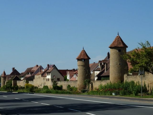
The former Mainbernheim town fortifications surround the old town of Mainbernheim in Lower Franconia as a ring wall with gates, towers, and remnants of a moat. Large parts of the complex, which dates back to the time of the town's elevation at the beginning of the 15th century, have been preserved to this day.
History+
Town Foundation and Fortification Construction+
The history of the Mainbernheim town fortifications is closely linked to the imperial policy of the emperors from the House of Luxembourg, who acquired the village in 1367. As an imperial village, Bernheim had held a special position among the places of the Prince-Bishopric of Würzburg since 1172. With the transfer to the Crown of Bohemia, the inhabitants received the right to build a palisade fence and a moat. Decisive for this rise was Mainbernheim's location on the route between Bohemia and Luxembourg. The place was first mentioned as a town on January 18, 1367, in a document by King Wenceslaus of Bohemia.
A town fortification consisting of a ring wall, gates, and moats was first mentioned in another document by Wenceslaus. On August 8, 1382, Mainbernheim officially received market and town rights from its ruler. In addition, the inhabitants were to equip the town "with ditches and other necessary things." The market right was an important basis for the expansion of the fortifications. By regularly holding markets, the inhabitants were able to maintain the maintenance-intensive town wall at all. The construction burden, as in many other Franconian towns, was borne by the local population and not by the town lord. However, after the right to erect fortifications was granted, it still took several decades until construction actually began. Robert Neußner assumes that the current ring wall dates back to predecessors from the first half of the 15th century. The town population participated in the erection of the walls in the form of manual and team services. It is documented that construction on the walls was still ongoing in 1425. In 1492, the stone ground floor of the Lower Gate was completed. In the event of an attack, the town population was obliged to defend. For this purpose, rifles and arquebuses were stored in the powder tower on the north side of the wall, which were distributed to the townspeople. In addition, the town also employed a full-time tower keeper who lived in the Upper Gate. However, the Mainbernheim town fortifications had a great symbolic benefit in addition to their real, military function. They served as a deterrent to potential enemies and at the same time formed Mainbernheim's most striking town feature. On December 7, 1494, however, the new town fortifications were overcome by the troops of Anton von Bibra and Neidhard von Thüngen, who then ruled the town for six years.
Decline and Tourism+
The wall lost its defensive function at the latest during the Thirty Years' War. Mainbernheim's fortifications could not withstand the modern cannons of the imperial soldiers. Nevertheless, during the warlike conflicts, the town was a refuge for various population groups from the surrounding area who had to do without such security facilities. Therefore, the town population initially grew during the war. Nevertheless, the security facilities lost importance in the course of the 17th century. During the siege of 1690, when the town tried to restore its traditional imperial freedom, the attack of the Margrave of Ansbach's troops came to a halt in front of the fortifications. A siege ensued. Finally, the attackers blew their way through the fortifications and entered the town. As a result, hardly any more was invested in the facilities. Only the two gate towers were expanded. Both also had great importance for Mainbernheim's economy as customs posts. They were the "bottlenecks" through which goods entered the town. While in many other Franconian towns in the 19th century, traffic led to the demolition of town gates in particular, because the narrowness of the passages provoked traffic accidents, Mainbernheim's two gate complexes remained. The pride of the town population is also evident on the emergency banknotes printed in the 1920s, on which the Upper Tower is depicted. The construction of a bypass road, which was inaugurated in 1938, also ensured its preservation. From then on, traffic was diverted around Mainbernheim. This relief of the old town also led to the town fortifications on the north side with their tower complexes becoming a popular photo motif for tourists. Only north of the Protestant parish church did parts of the wall and several towers disappear. Growing tourism in the Kitzinger Land was one of the reasons why the town council decided in the 1970s to extensively renovate the town fortifications. Today, the moat gardens, which were created in the filled-in town moat in the 18th century and leased to citizens, play a special role in marketing the former fortifications. Today, large parts of the former town fortifications are classified as architectural monuments by the Bavarian State Office for Monument Preservation, and subterranean remains of earlier buildings are noted as archaeological monuments. The fortifications form an important element of the Mainbernheim Old Town ensemble.
Gates+
As a classic two-gate town, Mainbernheim could only be entered via two routes in the Middle Ages and early modern period. The gates in the direction of Kitzingen and Nuremberg did not receive colloquial names here, but were named after their location in relation to the Herrnstraße running behind them. Only the Upper Gate received an alternative designation. The gates had defensive functions, so they could only be reached by a drawbridge over the moat in front of them and at the same time formed the customs borders of the town.
Upper Gate+
The Upper Gate (also Weidter Turm) was built around 1400. The stone passage probably dates back to this time. After the Thirty Years' War, in which Mainbernheim was spared major destruction, the tower was rebuilt. In the following period, the gate increasingly lost its military significance. Therefore, in 1777, several families moved into the tower, which had previously undergone another renovation phase. The tower keeper, who had to warn the town population of fire, also lived in the Upper Gate. The complex presents itself as a five-story rectangular tower. The tower gets its characteristic appearance from the uppermost floor. It was supplemented over a rectangular substructure as an octagonal attachment. The upper floor is richly structured in the style of Margravial Baroque and features pilaster strips and oculi. Illumination is made possible by simple rectangular windows. Above the uppermost floor rises a mansard roof, in which wooden dormer windows were housed.
Lower Gate+
The Lower Gate was erected between 1408 and 1414. However, the Lower Gate was first mentioned in a document in 1492. At that time, the Gothic ground floor was renovated or renewed. The work dragged on into the early 16th century. In the 17th century, the complex was equipped with a kind of outwork.
Source: Wikipedia · Licence: CC BY-SA 4.0 · Image: Reinhold Schulz
This description is a machine translation of an excerpt from the linked Wikipedia article. The source text was written by its authors, the translation is by Mobile History; like the original it is licensed under CC BY-SA 4.0.
Location: 49.7104, 10.2176