The City Wall can be visited
Town FortificationEinbeck
Stadtbefestigung Einbeck
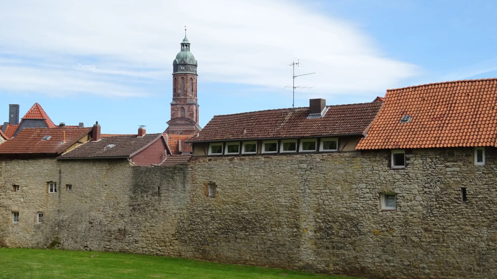
The city fortifications of Einbeck were a system of defensive structures for the city of Einbeck in the Middle Ages. They included a city wall, completed around 1300, over two kilometers long with two dozen wall towers and five city gates. Outside the wall, the city was later partially expanded into a fortress-like structure with moats, ramparts, and bastions, following Dutch models. After the Seven Years' War (1756–1763), the demolition of the fortifications began with the blowing up of the city gates. Nevertheless, about a third of the city wall with several towers, as well as moats and ramparts, are still preserved today. Hardly any remains of the Einbeck Landwehr, located in the vicinity of the city, are still visible today.
City Wall in the 13th and 14th Century+
Already the market settlement, as the nucleus of the city of Einbeck, was protected in the 12th century by a water-bearing, up to 4 m deep and 15 m wide, defensive moat. Around 1250, the Neustadt was included in a fortification system. This was done by an approximately 2200 meter long earthen rampart with a 16 m wide and 2 m deep water-bearing moat, which could be crossed via wooden bridges in the area of the five city exits. The construction of the city wall began around the middle of the 13th century and was first mentioned in a document in 1264. The city wall, made of mortared limestone rubble, was completed around 1300. Attached to the earthen rampart, it enclosed the Old Town and New Town as well as the St. Alexandri collegiate district. The merlon-less wall had a length of about 2.2 km and a height between 6 and 9 m. It was about 1 to 1.5 m thick. On the city side, directly behind the wall, ran an undeveloped, passable lane. Since the enclosed area crossed the stream valley of the Krummes Wasser, the watercourse was diverted for almost one kilometer to the south around the fortification. To secure the city wall system, at least 22 wall towers were built, the exact number of which can no longer be reconstructed today. They were located at regular intervals of 60 to 70 meters and at points where the city wall bent. The towers were designed as square or semicircular shell towers open to the city side, or as square closed flanking towers. Residential use of the wall towers was first reported in 1421, which later extended to the gate towers. It was only abandoned in the middle of the 18th century due to the poor structural condition of the facilities. There were five city gates, which were mentioned from 1318 onwards and served to control traffic. They had passage widths of two to three meters. These were the Ostertor and the Altendorfer Tor in the east, the Benser Tor in the south, and the Hullerser Tor and the Tiedexer Tor in the west. The city gates were designed as gate towers, which, like the wall towers, were built of white limestone rubble with red sandstone surrounds. The towers had a roof covering of black slate tiles from the Harz mountains.
Fortress-like Expansion in the 15th and 16th Century+
While the reinforcement of the city fortifications previously consisted of a vertical elevation of walls and towers, the use of gunpowder weapons, such as artillery, in the 15th century led to horizontally structured fortifications (modern fortresses) with ramparts and moats in front of the city wall, which lost importance. The outer ring of fortifications in Einbeck was functional in the middle of the 15th century, as at that time wall and gate towers were rented out and building plots were allocated on the inside of the city wall. Already in the 14th century, the inner city gates were reinforced with an outer gate. At the beginning of the 15th century, an additional outer gate was built about 70 m in front of the inner gates. A moat 25 to 45 m wide was dug around the entire city, and an earthen rampart almost three kilometers long, 20 to 60 m wide, and 6 to 7 m high was thrown up. At the beginning of the 15th century, several closed powder towers were built, which were only accessible from the city wall. Around 1500, cannon bastions were erected to counter the increasingly powerful cannons. A battery tower was built in the Ostertor, the so-called Diekturm was erected to reinforce the Benser Tor, and behind the Minster Church in the north, Raven's Zwinger and the Hohe Batterie were built. In the 17th century, during the Thirty Years' War, the defensive structures were further expanded into fortress-like structures with hornworks, smaller earth redoubts, and rondels. However, these remained largely ineffective: the city was shelled and occupied several times. The Merian city view from 1654 shows a beautified picture of the city, as it does not reflect the destructions and is incorrect in details, such as the number of wall towers.
Einbeck Landwehr+
The Einbeck Landwehr, as an outer defensive ring, consisted of low ditches and hedged ramparts. In the 15th century, it enclosed the Einbeck Feldmark in an almost complete circle with a diameter of 7 to 8 kilometers and a circumference of about 23 kilometers. At the important roads, the passages were secured by a total of seven stone watchtowers with barriers. The Landwehr fell into disrepair from the 17th century onwards and was finally completely abandoned in the 19th century.
Decay and Current State of Preservation+
The Einbeck city fortifications were severely damaged during the Thirty Years' War. In 1632 and 1641, parts of the fortifications and more than 300 houses were destroyed by cannon fire from imperial troops under Pappenheim and Piccolomini. In the Seven Years' War, the city was repeatedly occupied by French troops, who on November 10, 1761, during their withdrawal under Duke de Broglie after the battles at the Hube, blew up significant parts of the city fortifications and the Landwehr, including Raven's Zwinger, the rampart and the city wall south of the Ostertor, the water tower, and the outer Altendorfer Tor. The demolished fortifications were then definitively not restored. In 1741, the city council sold its cannons to pay for the construction of a retaining wall for the market church tower. In 1760, the last municipal cannons and mortars had to be delivered to Göttingen. The city fortifications fell into disrepair after the Seven Years' War, although Einbeck was still a garrison town. Until the late 19th century, gates, walls, and ramparts were removed and used as gardens. Nevertheless, significant parts of the city fortifications are still preserved today, especially in the west and south of the city. The city wall with the wall towers is completely preserved between the former Tiedexer and Hullerser Tor with the associated moats and ramparts. A semicircular shell tower (Storchenturm) still stands at its full height in the southwest. The powder tower south of the former Altendorfer Tor is also completely preserved, while the Knochenturm, also used as a powder tower, north of St. Alexandri, is only preserved as a few meters high ruin. In the former Benser Tor, the battery tower (Diekturm) still stands at a height of 11 to 14 m with a diameter of 12.8 m. Remains of a gun emplacement (Obere Katze) are preserved from the fortification of the Tiedexer Tor. Large parts of the former ramparts are now used as parks. The preserved parts of the city fortifications are now listed as historical monuments.
Take Mobile History with you
You are reading this text for free. Premium adds what matters on the road: descriptions read aloud, sites found through your camera, whole regions taken offline.
- Every description, including the ~17,700 Premium sites
- Audio guide: have descriptions read to you on location
- AR finder: see sites through your camera, with distance and bearing
- Unlimited saved sites
14 days free, then from €2.99 a month. Cancel anytime.
Source: Wikipedia · Licence: CC BY-SA 4.0 · Image: Foto: Jörg Heldt (Community)
This description is a machine translation of an excerpt from the linked Wikipedia article. The source text was written by its authors, the translation is by Mobile History; like the original it is licensed under CC BY-SA 4.0.
Location: 51.8183, 9.8625